
Durango, officially named Estado Libre y Soberano de Durango, is one of the 31 states which make up the 32 Federal Entities of Mexico, situated in the northwest of the country. With a population of 1,832,650, Durango has Mexico's second-lowest population density, after Baja California Sur. The capital city, Victoria de Durango, is named after the first president of Mexico, Guadalupe Victoria.

Culiacán, officially Culiacán Rosales, is a city in northwestern Mexico that is the capital of and the largest city in Sinaloa and in the Culiacán Municipality. It was founded on September 29, 1531 by the Spanish conquerors Lázaro de Cebreros and Nuño Beltrán de Guzmán under the name of Villa de San Miguel, which referred to its patron saint, Michael the Archangel.
Mazatlán is a city in the Mexican state of Sinaloa. The city serves as the municipal seat for the surrounding municipio, known as the Mazatlán Municipality. It is located at 23°13′N106°25′W on the Pacific coast, across from the southernmost tip of the Baja California Peninsula.
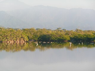
Marismas Nacionales-San Blas mangroves is a mangrove ecoregion of the Pacific coast of Mexico. The marismas nacionales stretches from Mazatlán, Sinaloa southwards to San Blas, Nayarit.
Federal Highway 40, also called the Carretera Interoceánica, is a road beginning at Reynosa, Tamaulipas, just west of the Port of Brownsville, Texas, and ending at Fed. 15 in Villa Unión, Sinaloa, near Mazatlán and the Pacific coast. It is called Interoceanic as, once finished, the cities of Matamoros, Tamaulipas, on the Gulf of Mexico and Mazatlán on the Pacific Ocean will be linked.
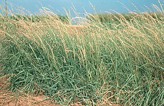
Bouteloua is a genus of plants in the grass family. Members of the genus are commonly known as grama grass.

The Bolsón de Mapimí is an endorheic, or internal drainage, basin in which no rivers or streams drain to the sea, but rather toward the center of the basin, often terminating in swamps and ephemeral lakes. It is located in the center-north of the Mexican Plateau. The basin is shared by the states of Durango, Coahuila, Chihuahua, and Zacatecas. It takes its name from Mapimí, a town in Durango.

Hurricane Naomi was a short-lived Category 1 hurricane that made landfall in Mexico's Pacific coast during the 1968 Pacific hurricane season. After rapidly intensifying before its landfall in Sinaloa, Naomi caused rainfall throughout northern Mexico and the U.S. state of Texas in association with a frontal system, with the highest measurement occurring in Corpus Christi. Four people perished in Mexico due to Naomi's effects with ten more missing, all in Sinaloa. The only reported injury in Texas due to the remnants was a factory worker who was injured when the roof of the plant they were working in collapsed due to rainfall.

Pueblo Nuevo is one of the 39 municipalities of Durango, in northwestern Mexico. The municipal seat lies at El Salto. The municipality covers an area of 6178.3 km².

The Sinaloa River is a river of Mexico. It runs across the state of Sinaloa from northeast to southwest, beginning in the Sierra Madre Occidental and emptying into the Gulf of California. Its flow is interrupted mostly by the Bacurato Dam which created Lake Baccarac in 1978. Below the dam, the flow of the river is largely diverted by an irrigation canal near the town of Sinaloa de Leyva.
The Presidio River is a river of Mexico. It originates in the mountains of Durango, flowing south-southwesterly into Sinaloa before joining the Pacific Ocean southeast of Mazatlán. The watershed measures 6,479 km2 (2,502 sq mi).
The Huaynamota River is a river in western Mexico. It is a tributary of the Río Grande de Santiago in the southern Sierra Madre Occidental.

The Baluarte Bridge, officially the Baluarte Bicentennial Bridge, is a cable-stayed bridge in Mexico. It is located between the municipalities of Concordia in Sinaloa and Pueblo Nuevo in Durango, along the Durango–Mazatlán highway, Mexico 40D. The bridge has a total length of 1,124 m (3,688 ft), with a central cable-stayed span of 520 m (1,710 ft). With the road deck at 403 m (1,322 ft) above the valley below, the Baluarte Bridge is the third-highest cable-stayed bridge in the world, the seventh-highest bridge overall and the highest bridge in the Americas.
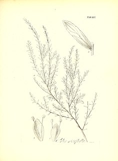
Salix taxifolia, the yewleaf or yew-leaf willow, is a species of willow native to all of southern Mexico, also Pacific Coast regions, north to Sinaloa, and in the south Pacific Coast of Mexico into central Guatemala. Scattered populations are also reported from northern Mexico and from the US states of Texas, New Mexico, and Arizona.
Federal Highway 36 is a free part of the federal highways corridors of Mexico. The highway construction is entirely within the state of Durango. The official start of the highway indicates it begins in the city of Topia then runs eastward to the town of Los Herrera. However, the paved and graded portion of the road does not go to Topia. Along the graded and paved road at a point about 96 km (60 mi) from Santiago de Papasquiaro a narrow and ungraded road leads off of Fed. 36 and extends 28 km (17 mi) to Topia, Durango. The road from Fed. 36 to Topia is a narrow dirt road. The paved and graded road system continues past that intersection and has been extended year by year in a westward direction to the crest of the Sierra Madre Occidental and down the western slope of the Sierras, following the drainage of the Topia River, past Canales, Durango and then on to the end of construction in a dead end about 24 km. beyond Canales at the remote village of La Angostura. This village just happens to be the home of Ines Coronel Barreras, a cattle rancher and Sinaloa drug lord, who is the father of Emma Coronel Aispuro, the Mexican beauty queen and wife of the internationally notorious drug lord Joaquin "El Chapo" Guzman, currently indicted and in jail in the United States for drug related crimes. This terminus of the graded and paved road is only 32 km (20 mi) by direct line from Tamazula de Victoria, Durango. It is unknown whether there will be further road construction beyond La Angostura to Tamazula de Victoria in the coming years though that would be feasible from an engineering standpoint. Until the completion of the highway construction an alternative route which is ungraded branches off the paved road on the crest of the mountains and continues on to highways in the state of Sinaloa. Those routes are all noted below.

Northern Mexico, commonly referred as El Norte, is an informal term for the northern cultural and geographical area in Mexico. Depending on the source, it contains some or all of the states of Baja California, Baja California Sur, Chihuahua, Coahuila, Durango, Nuevo León, Sinaloa, Sonora and Tamaulipas.

The Chínipas is river of northwestern Mexico. The Chinipas arises deep in the Sierra Madre Occidental in the state of Chihuahua, and then flows through long rugged canyon systems into the state of Sinaloa until it finally joins the main trunk of the Fuerte River in the western foothills of the Sierra Madre Occidental. The Fuerte River then flows westward over the western coastal plain of Sonora to the Pacific Ocean, emerging very near the port of Topolobampo.
Federal Highway 40D is the designation for toll highway paralleling Mexican Federal Highway 40. Highway 40D connects Mazatlán, Sinaloa to Reynosa, Tamaulipas. It forms most of the highway corridor between Mazatlán and Matamoros, Tamaulipas, one of 14 major highway corridors in the country.
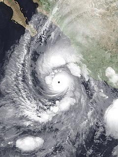
Hurricane Willa was a powerful tropical cyclone that brought torrential rains and destructive winds to southwestern Mexico, particularly the states of Sinaloa and Nayarit, during late-October 2018. It was the twenty-fifth tropical cyclone, twenty-second named storm, thirteenth hurricane, tenth major hurricane, and record-tying third Category 5 hurricane of the 2018 Pacific hurricane season. Willa was the first major hurricane to make landfall in the Mexican state of Sinaloa since Lane in 2006.

.%5B%5D)