Bandipora district

Last updated

Bandipora
District
Nickname(s): 
khuihaama
Jammu and Kashmir Bandipora district.svg
Location in Jammu and Kashmir
Coordinates: 34°25′12″N74°39′00″E / 34.42000°N 74.65000°E / 34.42000; 74.65000 Coordinates: 34°25′12″N74°39′00″E / 34.42000°N 74.65000°E / 34.42000; 74.65000
CountryFlag of India.svg  India
State Jammu and Kashmir
Seat Bandipora
Area
  District345 km2 (133 sq mi)
  Urban
49.6 km2 (19.2 sq mi)
  Rural
295.4 km2 (114.1 sq mi)
Population
(2011) [1]
  District392,232
  Density1,100/km2 (2,900/sq mi)
Time zone Indian Standard Time
Website bandipore.gov.in

Bandipora district is one of the 22 districts in Jammu and Kashmir state in northern India. Bandipora town is the administrative headquarters of the district. Bandipora, a township with peculiar scenic beauty is located in the foothills of the snow clad peaks of Harmukh overlooking the schores of Wular has produced hundreds, of scholars and intellectuals. Before, 1947, this town was a big trade and literary centre of Kashmir. Bandipora, the birthplace of great Historian, Hassan Khoehami. This district was carved out from the erstwhile Baramulla district in 2007. The district is bounded by Kupwara district in the west, Baramulla district in the south and Kargil, Srinagar and Ganderbal districts in the east. This district occupies an area of 398 km². [2] The district has a population of 392,232 as per 2011 census.

Jammu and Kashmir State in India

Jammu and Kashmir is a state in northern India, often denoted by its acronym, J&K. It is located mostly in the Himalayan mountains, and shares borders with the states of Himachal Pradesh and Punjab to the south. The Line of Control separates it from the Pakistani-administered territories of Azad Kashmir and Gilgit-Baltistan in the west and north respectively, and a Line of Actual Control separates it from the Chinese-administered territory of Aksai Chin in the east. The state has special autonomy under Article 370 of the Constitution of India.

India Country in South Asia

India, also known as the Republic of India, is a country in South Asia. It is the seventh largest country by area and with more than 1.3 billion people, it is the second most populous country as well as the most populous democracy in the world. Bounded by the Indian Ocean on the south, the Arabian Sea on the southwest, and the Bay of Bengal on the southeast, it shares land borders with Pakistan to the west; China, Nepal, and Bhutan to the northeast; and Bangladesh and Myanmar to the east. In the Indian Ocean, India is in the vicinity of Sri Lanka and the Maldives, while its Andaman and Nicobar Islands share a maritime border with Thailand and Indonesia.

Baramulla district District in Jammu and Kashmir, India

Baramulla district is one of the 22 districts in the Indian state of Jammu and Kashmir. Baramulla city is the administrative headquarters of this district. The district covered an area of 4,190 km² in 2001 but it was reduced to 3,353 km² at the time of 2011 census.

Contents

Education In Bandipora

Some of the noticeable institutions, colleges of Bandipora Which provide quality education to the students of district Bandipora

  1. Govt NM Boys Higher School Kaloosa Bandipora
  2. Govt Polytechnic College Bandipora
  3. Al-Noor College Of Education
  4. Mehboobul Aalam College Of Education
  5. Govt High School Bagh Bandipora
  6. Muslim Model School Qazipora Watapora
  7. Govt HKM Degree College Bandipora
  8. Army Good Will School Aythmulla
  9. Shaheen College Of Education.
  10. Govt Higher Sec. School Nadihal Bandipora.
  11. Govt Higher Sec. School Aloosa Bandipora
  12. Govt Higher Sec. School Aragam Bandipora.
  13. Govt Secondary School Mantrigam Bandipora.
  14. Govt Secondary School Bonakoot Bandipora
  15. Eaglets Public Secondary School Plan Bandipora
  16. SMS Islamia Model Higher Secondary School,Garoora

Divisions

The district comprises of seven tehsils: Ajas, Aloosa, Bandipora, Sumbal, Hajin, Gurez and Tulail. The district has three Vidhan Sabha constituencies: Gurez, Bandipora and Sonawari. All of these are part of Baramulla Lok Sabha constituency. The district comprises of twelve community development blocks: Aloosa, Arin, Baktoor, Bandipora, Bonkoot, Ganastan, Gurez, Hajin, Naidkhai, Nowgam, Sumbal and Tulail.

The Vidhan Sabha or the State Legislative Assembly is the lower house of a state legislature in the States and Union Territories of India. In the 29 states and 2 union territories with unicameral state legislature it is the sole legislative house. In 7 states it is the lower house of their bicameral state legislatures with the upper house being Vidhan Parishad or the State Legislative Council. 5 Union Territories are governed directly by the Union Government and have no legislative body. Members of a Vidhan Sabha are referred to as MLAs and are directly elected to serve 5 year terms by single-member constituencies. In 14 states the Governor of a state may appoint one Anglo-Indian MLA to their respective states Vidhan Sabha in accordance with the 23rd Amendment of the Constitution of India. The Constitution of India states that a Vidhan Sabha must have no less than 60 and no more than 500 members however an exception may be granted via an Act of Parliament as is the case in the states of Goa, Sikkim, Mizoram and the union territory of Puducherry which have fewer than 60 members. A Vidhan Sabha may be dissolved in a state of emergency, by the Governor on request of the Chief Minister, or if a motion of no confidence is passed against the majority coalition.

Gurez constituency in Jammu and Kashmir, India

Gurez, or Gurais, is a valley located in the high Himalayas, about 86 kilometres (53 mi) from Bandipore and 123 kilometres (76 mi) from Srinagar in northern Kashmir and southern Gilgit-Baltistan. At about 8,000 feet (2,400 m) above sea level, the valley is surrounded by snow-capped mountains. It has diverse fauna and wildlife including the Himalayan brown bear and the snow leopard. The Kishanganga River flows through the valley. The road to Gilgit runs through Gurez.

Baramulla Lok Sabha constituency is one of the six Lok Sabha (parliamentary) constituencies in Jammu and Kashmir state in northern India. Baramulla has 11.5 lakh voters.

Demographics

According to the 2011 census Bandipora district has a population of 385,099, [3] roughly equal to the nation of Maldives. [4] This gives it a ranking of 561st in India (out of a total of 640). [3] The district has a population density of 1,117 inhabitants per square kilometre (2,890/sq mi) . [3] Its population growth rate over the decade 2001-2011 was 26.31%. [3] Bandipora has a sex ratio of 911 females for every 1000 males, [3] and a literacy rate of 57.82%. [3]

Demographics of India

India is the second most populated country in the world with nearly a fifth of the world's population. According to the 2017 revision of the World Population Prospects, the population stood at 1,324,171,354.

Maldives South Asian country in the Indian Ocean

The Maldives, officially the Republic of Maldives, is an Asian country, located in the Indian Ocean, situated in the Arabian Sea. It lies southwest of Sri Lanka and India, about 1,000 kilometres (620 mi) from the Asian continent. The chain of 26 atolls stretches from Ihavandhippolhu Atoll in the north to the Addu City in the south. Comprising a territory spanning roughly 298 square kilometres (115 sq mi), the Maldives is one of the world's most geographically dispersed sovereign states as well as the smallest Asian country by land area and population, with around 427,756 inhabitants. Malé is the capital and a populated city, traditionally called the "King's Island" for its central location.

Family planning in India

Family planning in India is based on efforts largely sponsored by the Indian government. From 1965–2009, contraceptive usage has more than tripled and the fertility rate has more than halved, but the national fertility rate remains high, causing concern for long-term population growth. India adds up to 1,000,000 people to its population every 20 days. Extensive family planning has become a priority in an effort to curb the projected population of two billion by the end of the twenty-first century.

See also

Related Research Articles

Pulwama district District of Jammu and Kashmir in India

Pulwama is a district in Indian state of Jammu and Kashmir. District Pulwama came into being in the year 1979 in the larger interests of maintenance of law and order, closer supervision, more effective control and above all to ensure balanced development of the area. The district is centrally located in the valley of Kashmir and is a resting place for adventure tourists since it has abundant water and hospitable countryside. The district has also been nicknamed the rice bowl of Kashmir for its production of rice. Besides Pulwama is famous all over the world for Saffron cultivation which is mainly grown in the Pampore, Kakapora and Pulwama blocks. Pulwama is often called the 'Anand of Kashmir' or 'Dudha-Kul of Kashmir' on account of its high milk production. The National Highway NH1 that connects Srinagar and Jammu passes through Pulwama. This place is also where more than 40 CRPF Jawans were killed by an attack purported by Jaish-e-Mohammed on 14th February 2019.

Tirurangadi town in Kerala, India

Tirurangadi is a municipal and census town in Malapuram district of Kerala, South India. It is a historical town which is famed for its active participation in the freedom struggle, especially those dating back to 1920s. It is a Municipality and a taluk. It is located 25 km west of Malappuram, the district headquarters, 30 km south of Calicut and 140 km north of Ernakulam.

Chengalpattu Town in Tamil Nadu, India

Chengalpattu is a town in Kancheepuram district, Tamil Nadu, India. It is the headquarters of the Chengalpattu Taluk of the district and is 55 kilometres (34 mi) southwest of the state capital, Chennai and 22 km Away from Chennai City Entrance Gateway Chennai Vandalur on the National Highway 45. Chengalpattu Railway Station, technically known as CGL, is one of the major railway junctions of the Southern Railway and is a nationally important halt.

Sidhi district District of Madhya Pradesh in India

Sidhi District is one of the tribal districts of Madhya Pradesh state of India. The town of Sidhi is the district headquarters. The district is part of Rewa Division.

Ambala district District of Haryana in India

Ambala district is one of the 22 districts of Haryana state in the country of India with Ambala town serving as the administrative headquarters of the district. It borders district Yamunanagar to the east, district Sirmaur and district Panchkula to the north, district Mohali and district Patiala to the west, and the district of Kurukshetra to the south.

Dimapur district District in Nagaland, India

Dimapur (Pron:/ˌdɪməˈpʊə/) is a district of Nagaland state in India. Its headquarters is the city of Dimapur. As of 2011 it is the most populous district of Nagaland.

Sopore City in Jammu and Kashmir, India

Sopore known as Suyyapur in antiquity, is a town in the Baramulla district of Jammu and Kashmir, India. It is 45 km (28 mi) north-west of Srinagar, and 16 km (10 mi) south-west from the city of Baramulla.

Bandipora Town in Jammu & Kashmir in Jammu and Kashmir, India

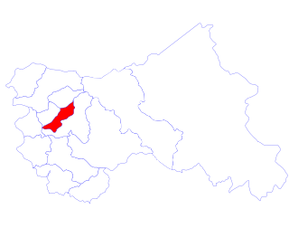
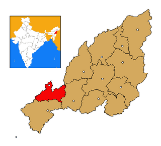
Bandipora is an administrative division of district of Bandipora, headquarters in Bandipora the state of Jammu and Kashmir, India. It is located on the northern banks of Wular—the second-largest freshwater lake in Asia. Bandipora has a terraced garden similar to that of Nishat Bagh in Srinagar. In Kashmiri there is a well-known phrase about Bandipora or in other words Bandipora is famous for three As: A'lim (knowledge), Adab and Aab (water). As can be known from the folklore, the name of Bandipora originated either from Bund of Wular as Bund e pur, from the local folk-singing bands (bāṇd) as Baand e pur or from the enlosed (band) geographical location as Bandh e pur. Bandipora is bound by mountains on three sides and by Wular Lake on the fourth.

Ganderbal District in Jammu & Kashmir in Jammu and Kashmir, India

Ganderbal is a centrally located district and a municipality committee in Ganderbal district in the state of Jammu and Kashmir. It has an average elevation of 1,619 metres. It is bordered by district Srinagar in the south, Bandipore to the north, Kargil in the northeast, Anantnag to the south-east and Baramulla in the south-west. It is divided into four blocks viz, Ganderbal, Kangan, Lar and Wakoora. Nallah Sindh, a major tributary to the Jehlum river flows through this district. The water of the river is mainly used for irrigation and generation of Hydroelectricity. There are three Hydroelectric Power Stations, Lower Sindh Hydroelectric Power Project Ganderbal, Upper Sindh Hydroelectric Power Project 1st Kangan and Upper Sindh Hydroelectric Power Project 2nd Sumbal generating electricity on the river Nallah Sindh. Besides, the water of the river is used for drinking by the whole Srinagar city through Rangil Water Treatment Plant. Water rafting tournaments are being organised at the world-famous tourist destination Sonamarg every year, to boost the tourism industry of Kashmir valley. Besides Manasbal lake, Gangabal Lake at the foot of Mount Haramukh is one of the famous destinations of foreign tourists visiting the valley. The lakes of Vaishnosar and Gadsar Lake, situated north of Sonamarg are the beautiful mountain lakes of the world. Administrative Units:- District Ganderbal has 2 Assembly Constituencies:- 16-Kangan 17-Ganderbal District Ganderbal has 1 Sub-division:- Kangan District Ganderbal has 6 Tehsils:- Ganderbal Kangan Lar Tullamulla Gund Wakura

Kulgam Town in Jammu and Kashmir, India

Kulgam is a town, administrative division, and capital of the Kulgam district in the Indian state of Jammu and Kashmir. It is located at a distance of 67 kilometres from the summer state capital of Srinagar. The city is divided into 16 electoral wards that has population of 23,584, of which 12,605 are males while 10,979 are females.

Nadihal is a village located in the north of Jammu and Kashmir state in India. It is just 4 km away from Bandipora town, and 51 km away from Srinagar. It the largest village in Bandipora district. There are many small villages around it. It is a prosperous and modern village with a population of 5167. Nadihal is inhabited largely by Muslims. In this village there are two government middle schools, one higher secondary school, and two high schools. Besides Government run schools, there are a few private schools as well in this village The level of education in Nadihal is moderate, but has significantly increased in recent times.

Khulhama is a small village situated next to Nadihal, in Bandipora District, in the Indian state of Jammu and Kashmir. Its name is derived from khul - stream or river, and hama - region or village. It is located below the foot of Nadihal and includes a large wetland.

Government Degree College, Bandipora

Government Degree College Bandipora also known as HKM, GDC Bandipora, is University Grants Commission autonomous co-educational degree college affiliated with the University of Kashmir situated in Bandipora in the Indian administrated state of Jammu and Kashmir.The college is affiliated with University of Kashmir, Hazratbal Srinagar and is recognised by University Grants Commission of India under articles 2(f) and 12(b) of UGC Act, 1956.

There are about 47 Government and 3 Private Grant-in-Aid degree colleges in Kashmir province, of Indian administrated state of Jammu and Kashmir as per the data available by Jammu and Kashmir Higher Education Department. The colleges in Kashmir province are located in 10 districts.These districts include, Srinagar, Baramulla, Anantnag, Budgam, Kupwara, Pulwama, Ganderbal, Kulgam, Shopian and Bandipora. All the degree colleges of Kashmir province are affiliated to the University of Kashmir.

Hathlangoo Village in Jammu and Kashmir

Hathlangoo previously known as Hashmatpora is a village in the Sopore tehsil of Baramulla District in Jammu and Kashmir. It is located 8 km (5.0 mi) away from sub-district headquarter Sopore and 22 km (14 mi) away from district headquarter Baramulla. It is one of the largest villages in Zaingair. Nearby villages include Muqam, Malpora, Magraypora, Botingoo, Watlab, Janwara and Warpora.

Indian Army operations in Jammu and Kashmir include security operations such as Operation Rakshak (Protector) and Operation Sarp Vinash. Other operations include humanitarian missions such as Operation Megh Rahat and operations with a social aim such as Operation Goodwill and Operation Calm Down.

References

  1. Census of India 2011
  2. Srivastava, Dayawanti et al (ed.) (2010). India 2010, A Reference Annual (PDF). New Delhi: Publications Division, Ministry of Information and Broadcasting, Government of Indiaand. p. 1142. ISBN   978-81-230-1617-7.CS1 maint: Extra text: authors list (link)
  3. 1 2 3 4 5 6 "District Census 2011". Census2011.co.in. 2011. Retrieved 2011-09-30.
  4. US Directorate of Intelligence. "Country Comparison:Population" . Retrieved 2011-10-01. Maldives 394,999 July 2011 est.