
Chittoor is a city and district headquarters in Chittoor district of the Indian state of Andhra Pradesh. It is also the mandal and divisional headquarters of Chittoor mandal and Chittoor revenue division respectively. The city has a population of 153,756 and that of the agglomeration is 175,647.

Kolar district is a district in the state of Karnataka, India.

Mandya is a city in the state of Karnataka. It is the headquarter of Mandya district and is located 45 kilometres (28 mi) from Mysore and 100 kilometres (62 mi) from Bangalore.

Madanapalle is the largest city in Annamayya district and Rajampet Lok Sabha constituency of the Indian state of Andhra Pradesh. It is a Selection Grade Municipal City Council. Madanapalle is headquarters of Madanapalle Mandal,Madanapalle revenue division and PKM Urban Development Authority.
Kuppam is a City in Chittoor district of the Indian state of Andhra Pradesh. It is located 115.8 kilometers south-east of Bangalore, the capital city of Karnataka, and 243 kilometers west of Chennai, the capital of Tamil Nadu. It is the headquarters of Kuppam mandal in the Kuppam Revenue Division. The name "Kuppam" means a meeting place or confluence.
Malur is a town and taluk headquarters in Kolar district of the Indian state of Karnataka. It is 30 km from Kolar, the district headquarters, and about 50 km from Bangalore. It is accessible from Bangalore by road and railways. The Chennai Central-Bangalore City line passes through Malur, with trains to various parts of India, including Tirupati, Chennai, Kochi, Trivandrum, Patna and Calcutta.
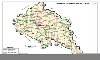
Shahapur is a city and taluka headquarter located in the Yadgir district of Indian state of Karnataka. Shahapur is 597 km north of Bangalore and well connected by road to Gulbarga (70 km), Hyderabad (240 km), Bidar (160 km), Raichur (90 km) and Yadgir (32 km).
Mulabagilu is a town and administrative center of Mulabagilu taluk, in the Kolar district in the state of Karnataka, India. The town is situated on the National Highway 75 and is the easternmost town of the state.

Budikote or Budhikote is a village situated in Bangarapet taluk of Kolar district in the Indian state of Karnataka. It is located about 15 mi (24 km) from the district headquarters Kolar Gold Fields, the nearest city; Bangarpet the nearest town is 12 km (7.5 mi) away and Bangalore is 125 km (78 mi). It is a gram panchayat and covers an area of 355.65 ha. According to the 2011 census data, Budikote village has a population of 3,347—of which 1,743 are male and 1,604 are female—and a household count of 600.

National Highway 4 was a major National Highway before National Highway renumbering in Western and Southern India. NH 4 linked four of the 10 most populous Indian cities – Mumbai, Pune, Bangalore, and Chennai. NH 4 was 1,235 km (767 mi) in length and passed through the states of Maharashtra, Karnataka b'lore and Tamil Nadu. It is now numbered as National Highway 48 (India). National Highway 4 was known as P.B.Road in many parts of Maharashtra and Karnataka states before it was renumbered.

Vaniyambadi is a town in the Tirupathur district of Tamil Nadu and the headquarter for the Vaniyambadi Revenue district comprising Vaniyambadi and Ambur. It is located about 200 km from Chennai and 178 kilometer from Bengaluru. The Vaniyambadi Municipality was formed by the G.O. MS. No. 421 Local & Municipality Dept. in April 1886. In 1996 this Municipality was upgraded to Grade II Municipality by G.O. MS. NO. 118 Rural Development Local Administration Dept. dated 01.05.1996. In 1998 this Municipality was upgraded to 1st Grade.

Kolar or Kolara is a city in the Indian state of Karnataka. It is the headquarters of Kolar district. The city is known for its milk production and gold mines. It is also known for the Someshwara and Kolaramma temples.
Punganur is a Municipality city in Chittoor district of the Indian state of Andhra Pradesh. It is the headquarters of Punganur Mandel of Palamaner Revenue Division.

Srinivaspur is a town located in the Kolar district of Karnataka state, India. The latitude 13.33 and longitude 78.22 are the geocoordinate of the Srinivaspur. Bengaluru is the nearby state capital for Srinivaspur town. It is located around 106 km away from Bengaluru and 80 km from BIAL. The other surrounding state capitals are Chennai 225.9 km., Pondicherry 233.2 km., Hyderabad 453.4 km.,
Basavana Bagewadi is a municipality and taluka in Bijapur district in the state of Karnataka, India.

Pakala is a town in Tirupati district of the Indian state of Andhra Pradesh. It is the mandal headquarters of Pakala mandal. It comes under Tirupati revenue division.

Kanigiri is a town in Prakasam district of the Indian state of Andhra Pradesh. It is a municipality and the headquarters of Kanigiri mandal in Kanigiri revenue division.
A municipal corporation is a type of local government in India which administers urban areas with a population of more than one million. The growing population and urbanization of various Indian cities highlighted the need for a type of local governing body that could provide services such as healthcare, education, housing and transport by collecting property taxes and administering grants from the state government.
Lavelle Road is an upmarket residential and commercial street in the city of Bangalore, Karnataka in India. It is an important connection between Mahatma Gandhi Square and Richmond Circle. The road starts from the Queens Road end of the M. Chinnaswamy Stadium and after curving in a serpentine manner meets the junction of Bangalore Club with Richmond Circle. Lavelle Road was named after Michael F Lavelle, an Irish soldier who later made his money in the Kolar Gold Fields.

Bangarapet Junction railway station, also known as Bangarapete Junction railway station is a double-line electrified railway station which is located in the heart of the city. It is one of the important railway stations in the Chennai Central–Bangalore City line where many people board and de-board for many purposes.

