Bangomunda

Last updated

Bangomunda
Banganmura
Tehsil
Nickname: 
BGM
India Odisha location map.svg
Red pog.svg
Bangomunda
Location in Odisha, India
India location map.svg
Red pog.svg
Bangomunda
Bangomunda (India)
Coordinates: 20°20′37″N82°54′35″E / 20.34361°N 82.90972°E / 20.34361; 82.90972
CountryFlag of India.svg  India
State Odisha
District Balangir
Government
  Block ChairmanRanjubala Behera
  SarpanchAjit Joshi
Elevation
182 m (597 ft)
  Density251/km2 (650/sq mi)
Languages
  Official Odia
  Local Sambalpuri
Time zone UTC+5:30 (IST)
PIN
767040
Telephone code06657
Vehicle registration OD-03
Coastline0 kilometres (0 mi)
Nearest city Kantabanji
Lok Sabha constituency Balangir
Vidhan Sabha constituency Kantabanji
Civic agency Block Gram Panchayat Tehsil
Climate Tropical monsoon (Köppen)
Avg. summer temperature40 °C (104 °F)
Avg. winter temperature20 °C (68 °F)
Website balangir.nic.in

Bangomunda is a tehsil in the Balangir district of Odisha, India with historical importance. [1] [ citation needed ] It is located 72 km (45 mi) from the district capital in the city of Balangir. Bangomunda was formerly known as Banganmura which means Brinjal Firm.

Contents

Places of interest

Ranipur-Jharial (also known as Somatirtha) is a tourist destination in Odisha just 7 km (4.3 mi) from Bangomunda. [2] Durga Mandir, a famous temple in the region, is situated on the bank of the village's pond.

Durga Mandir Bangomunda - Durga Mandir.jpg
Durga Mandir

Festivals

The people of Bangomunda celebrate most of the festivals of Odisha like Rath Yatra Durga Puja, Diwali, Kumar Purnima or Gaja Laxmi Puja, Manabasa Gurubar, Sabitri Brata, Makar Sankranti, Bishuba/Pana Sankranti, Dola Purnima or Holi, Gamha Purnima or Rakshya Bandhan, Kartik Purnima, Nabanna or Nuakhai, Pua jiuntia, Bhai jiuntia, Janmastami, Ram Navami, Saraswati Puja, and Ganesh Puja. The primary festival, however, is Nuakhai.

Some festivals are unique to the place, like Chatar jatra, Kansa Badha, Dhanu Yatra, [3] Navratri Durgapuja. Bhai jiuntia is celebrated during this time on Astami Tithi. In "Bhai jiuntia" sisters pray for their brothers' long life and tie a thread called "Jiuntia". Nuakhai is also an important festival which is celebrated on Panchami tithi of Bhadraba sukla pakshya.

Demographics

As per 2011 Census of India, Bangomunda had a population of 5,759, consisting of 2,802 males and 2,957 females. Schedule Castes constituted 1318 people and Schedule Tribes constituted 481 people. The literacy rate was 60.27% . [4]

Education

There are government schools in town for primary as well as secondary education. C.M. High School [5] is for class 8th to 10th. [6] Saraswati Shishu Mandir and Akhil Bharatiya English Medium School are private schools. Panchayat Samiti College is for college education, but is limited to arts stream only. [7]

Many of the students are studying outside the state for higher education and a few have studied abroad as well .

Beside educational institutes there are also centers for computer learning and industrial training.

Public transport

The town is in the center point of three commercial hubs of Odisha. Public transportation is limited here as only a bus facility is available. The nearest railway station is in Kantabanji which is about 16 km (9.9 mi) away. [8] The nearest airport is in Raipur.

Related Research Articles

<span class="mw-page-title-main">Balangir district</span> District of Odisha in India

Balangir District, also called Bolangir District, is a district situated in Odisha state of India. The district has an area of 6,575 km2 (2,539 sq mi), and a population of 1,648,997. The town of Balangir is the district headquarters. The composition of the land is predominantly rural. Other important big & small towns in Balangir district are Titlagarh, Patnagarh, Kantabanji, Loisingha, Saintala, Belpada, Tushra, Agalpur, Deogaon, Chudapali, Biripali, Bhalumunda, Bangomunda, Sindhekela, Turekela and Muribahal.

<span class="mw-page-title-main">Balangir</span> City in Odisha, India

Balangir also known as Bolangir, is a city and municipality, the headquarters of Balangir district in the state of Odisha, India. Balangir has one of the best cultural heritage in India. It is also known as one of the finest places for tourists in Odisha. Balangir municipality is divided into twenty-one wards. It is spread over an area of 12,200 acres (4,900 ha).

<span class="mw-page-title-main">Belaguntha</span> Town in Odisha, India

Bellaguntha is a town and a Notified Area Council (N.A.C.) in Odisha, India which was the main market of South Odisha in the time of British India. Bellaguntha is also known as Brass Fish Town.

<span class="mw-page-title-main">Bhanjanagar</span> Town in Odisha, India

Bhanjanagar is a town and an urban region. It is a Notified Area Council in the Ganjam District in the state of Odisha, India. The town, earlier named as Russellkonda after George Russell, President of then board of Revenue, was renamed later after Kavi Samrat Upendra Bhanja. Bhanjanagar is a planned community situated in the confluence of rivers Loharakhandi and Badanadi.

Brajrajnagar is a town and a municipality in Jharsuguda district in the state of Odisha, India. Popular legend says the town was named after Braj Mohan Birla after he set up Orient Paper Mills in 1936. It is a small sleepy town on rocky terrain, built on the banks of IB river, with temples mostly built by the Birlas. Later it became famous for MCL-owned coal mines after Orient Paper Mills of Birlas managed by dulichand Hanuman Prasad shah closed down in 1999.

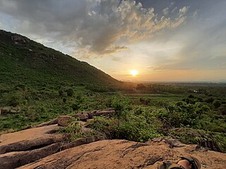
Kantabanji (KBJ) is a Municipality in Balangir district in the Indian state of Odisha.

<span class="mw-page-title-main">Sarala Temple</span> Hindu Goddess temple

The Maa Sarala Temple is a Hindu temple in the district of Jagatsinghpur, Odisha, India. It is one of the eight most famous Shakta shrines of Odisha.

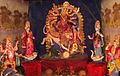
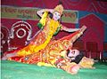
This article lists the traditional festivals and other cultural events in the Odisha region of India. Odisha celebrates 13 festivals in 12 months as the saying goes Bāra Māsare Tera Parba.

<span class="mw-page-title-main">Harishankar Temple</span> Temple in Odisha, India

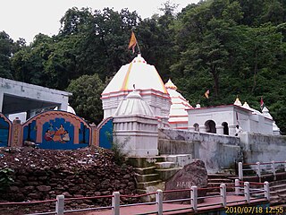
Sri Sri Harisankar Devasthana is a temple on the slopes of Gandhamardhan hills, Bolangir District of Odisha in India. It is popular for its scenes of nature and connection to two Hindu lords, Vishnu and Shiva. As a holy place, along with a stream passing on the granite bed, it has given some visitors a feeling of peace. On the opposite of side of the Gandhamardhan hills is the temple of Nrusinghanath. The plateau between the two temples has been found to have ancient Buddhist ruins, which are considered to be remnants of the ancient Parimalgiri University.

<span class="mw-page-title-main">Indralath Temple</span>

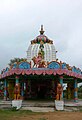
Indralatha Temple is dedicated to Shiva and is situated in Bangomunda block near Ranipur-Jharial in Balangir district. It was supposed that Indra first worshipped lord Shiva here and erected a temple.

<span class="mw-page-title-main">Durgapur, Angul</span> Village in Odisha, India

Durgapur is a village located in Angul district, in the Indian state of Odisha.

Here is a list of glossary of Culture of India in alphabetical order:

<span class="mw-page-title-main">Agalpur</span> Town in Odisha, India

Agalpur is a town and Block in Balangir district in the state of Odisha, India. Agalpur (Raj) a historical place and a very old human community centre. It is situated in the triangular land of "Ang" river ;and Two Small Rivers "Uttali"& "Ghesali". On the extreme north, after crossing the Ong river at about 10–20 km a beautiful hill is situated known as 'Chhelia Pahad".

Sisua is a medium-sized village in the Salipur taluk/mandal/tehsil/block of Cuttack district in the state of Odisha, India, close to the new Sisua Village Jagannath Temple. The village lies South of Cuttack to Kendraparda road left of Sisua village road if traveling South. As of 2009 Kantapara is the gram panchayat of Sisua village

Gopaipali is a small village under Barpali block in Bargarh District with village code 72500 as per 2001 Census.

Parikud is an island in Chilika Lake, Odisha, India. The land mass is spread over 97 mouzas of Krushnaprasad panchayat samiti. It is surrounded by Chilika Lake and the Bay of Bengal on two sides. The settlement Jahnikuda is located at the easternmost end of the island and acts as an access point to Puri. The residents of this area primarily work in agriculture and fishing. The current head of the island is Raja Santosh Chandra Deo.

Lahanda is a village in Odisha, India. It is located in the Attabira block of Bargarh district.

Sindhekela is a village in Balangir district in the Western Odisha region of Odisha India. Sindhekela comes under Sindhekela Gram Panchayat.

<span class="mw-page-title-main">Chausath Yogini Temple, Ranipur Jharial</span> Temple in Odisha

Chausath Yogini Temple of Ranipur Jharial in Balangir District, Odisha, is one of the circular, open air Yogini temples of India, dedicated to the 64 Yoginis. It appears to be an early temple from soon after 900 AD, and the presence of other temples indicates that it was an important site at that time. The surviving central shrine holds an image of dancing Shiva; all the Yogini images are, uniquely, similarly shown dancing.

References

  1. "Bangomunda village Bangomunda Panchayat Bangamunda Block BOLANGIR District Odisha orissa India". Naveenpatnaik.com. Archived from the original on 29 June 2013. Retrieved 9 March 2016.
  2. "Orissa Tourism - Ranipur Jharial,64 Yogini Temples, Orissa Temples, Orissa Tourism". Tourism.oriyaonline.com. Archived from the original on 18 June 2013. Retrieved 9 March 2016.
  3. "Archived copy". sambadepaper.com. Archived from the original on 11 March 2016. Retrieved 13 January 2022.{{cite web}}: CS1 maint: archived copy as title (link)
  4. "Census of India: Search Details". Censusindia.gov.in. Retrieved 9 March 2016.
  5. "Archived copy". sambadepaper.com. Archived from the original on 11 March 2016. Retrieved 13 January 2022.{{cite web}}: CS1 maint: archived copy as title (link)
  6. "C.M.High School, Bangomunda, Bolangir". eindiaeducation.com. Archived from the original on 24 May 2014. Retrieved 4 May 2018.
  7. "Panchayat Samiti Degree College, Bangomunda Results 2016". Indcareer.com. 4 December 2012. Retrieved 9 March 2016.
  8. "Bangomunda to Kantabanji". web page. distancesto. Retrieved 20 January 2015.