
County Down is one of the six counties of Northern Ireland, one of the nine counties of Ulster and one of the traditional thirty-two counties of Ireland. It covers an area of 961 sq mi (2,490 km2) and has a population of 552,261. It borders County Antrim to the north, the Irish Sea to the east, County Armagh to the west, and County Louth across Carlingford Lough to the southwest.
Bangor is a city and seaside resort in County Down, Northern Ireland, on the southern side of Belfast Lough. It is within the Belfast metropolitan area and is 13 miles (22 km) east of Belfast city centre, to which it is linked by the A2 road and the Belfast–Bangor railway line. The population was 64,596 at the 2021 census. Bangor was granted city status in 2022, becoming Northern Ireland's sixth city.
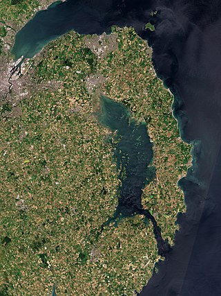
The Ards Peninsula is a peninsula in County Down, Northern Ireland, on the north-east coast of Ireland. It separates Strangford Lough from the North Channel of the Irish Sea. Towns and villages on the peninsula include Donaghadee, Millisle, Portavogie and Portaferry. The large towns of Newtownards and Bangor are at the mainland edge of the peninsula. Burr Point is the easternmost point on the island of Ireland.
A townland is a small geographical division of land, historically and currently used in Ireland and in the Western Isles in Scotland, typically covering 100–500 acres (40–202 ha). The townland system is of Gaelic origin, antedating the Norman invasion, and most have names of Irish origin. However, some townland names and boundaries come from Norman manors, plantation divisions, or later creations of the Ordnance Survey. The total number of inhabited townlands in Ireland was 60,679 in 1911. The total number recognised by the Irish Place Names database as of 2014 was 61,098, including uninhabited townlands, mainly small islands.

Millisle or Mill Isle is a village on the Ards Peninsula in County Down, Northern Ireland. It is about 3 miles (4.8 km) south of Donaghadee. It is situated in the townlands of Ballymacruise and Ballycopeland, the civil parish of Donaghadee and the historic barony of Ards Lower. It had a population of 2,318 people in the 2011 Census.

Groomsport is a suburb of Bangor in County Down, Northern Ireland. It is on the south shore of Belfast Lough and on the north coast of the Ards Peninsula. Groomsport has a population of 3,005 people according to the 2011 Census. It is part of the Ards and North Down Borough.

Ballywalter is a village or townland and civil parish in County Down, Northern Ireland. It is on the east coast of the Ards Peninsula between Donaghadee and Ballyhalbert. Ballywalter was formerly known as Whitkirk as far back as the 12th century. It had a population of 2,027 people in the 2011 census.
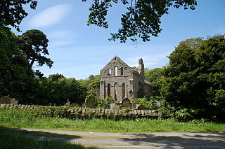
Greyabbey or Grey Abbey is a small village, townland and civil parish located on the eastern shores of Strangford Lough, on the Ards Peninsula in County Down, Northern Ireland.
Balloo is a small village and townland near Killinchy in County Down, Northern Ireland. It is 5 miles south of Comber on the A22 road between Belfast and Downpatrick. It is situated in the townland of the same name, the civil parish of Killinchy and the historic barony of Dufferin. It lies within the Ards and North Down Borough. It had a population of 189 people in the 2011 Census.
Ballymartin is one of several places on the island of Ireland.
Ballyhay is a townland near Donaghadee in County Down, Northern Ireland. It is in the civil parish of Donaghadee and the historic barony of Ards Lower. It is called Bellyhie in Ulster-Scots.
Ards Lower, alternatively known as North Ards, is a barony in County Down, Northern Ireland. It lies on the northern half of the Ards Peninsula in the north-east of the county, with the Irish Sea to its east and Strangford Lough to its south-west. It is bordered by two other baronies: Ards Upper to the south; and Castlereagh Lower to the west.
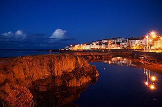
Donaghadee is a civil parish in County Down, Northern Ireland. It is situated in the historic barony of Ards Lower.

Tullynakill is a civil parish and townland in County Down, Northern Ireland. It is situated in the historic barony of Castlereagh Lower.

Alan Chambers is a Northern Irish unionist politician who was acting Speaker of the Northern Ireland Assembly between 2022 and 2024. Chambers has been an Ulster Unionist Party (UUP) Member of the Northern Ireland Assembly (MLA) for North Down since 2016. He currently serves as Chairperson of the Assembly's Audit Committee.

Lisbane is a small village and townland in the parish of Tullynakill and the barony of Castlereagh Lower in County Down, Northern Ireland. It is between Balloo and Comber on the A22 road, 5 kilometres south-east of Comber. It is near Strangford Lough in the Ards and North Down Borough Council.

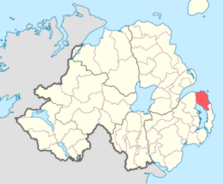
Bangor East and Donaghadee is one of the seven district electoral areas (DEA) in Ards and North Down, Northern Ireland. The district elects six members to Ards and North Down Borough Council and contains the wards of Ballycrochan, Ballymagee, Donaghadee, Groomsport, Silverbirch and Warren. Bangor East and Donaghadee forms part of the North Down constituencies for the Northern Ireland Assembly and UK Parliament.
