
Heidelberg is a suburb of Melbourne, Victoria, Australia, 11 kilometres (7 mi) northeast of Melbourne's central business district. Its local government area is the City of Banyule. In 2016, Heidelberg had a population of 6,225.

Elizabeth Street is one of the main streets in the central business district of Melbourne, Victoria, Australia, part of the Hoddle Grid laid out in 1837. It is presumed to have been named in honour of governor Richard Bourke's wife.

Flagstaff Gardens is the oldest park in Melbourne, Victoria, Australia, first established in 1862. Today it is one of the most visited and widely used parks in the city by residents, nearby office workers and tourists. The gardens are notable for their archaeological, horticultural, historical and social significance to the history of Melbourne.

La Trobe Street is a major street and thoroughfare in the city centre of Melbourne, Victoria, Australia. It runs roughly east–west and forms the northern boundary of Melbourne's central business district. The street was laid out as an extension of the original Hoddle Grid in 1839 and was named after Charles La Trobe. La Trobe Street extends from Victoria Street in the east to Harbour Esplanade in the west.

Victoria Street is one of the major thoroughfares of inner Melbourne, running east–west for over six kilometres between Munster Terrace in North Melbourne and the Yarra River. The road is known as Victoria Parade for over one-and-a-half kilometres of its length, distinguishable with a wide reservation and tramway down the middle.
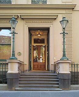
The Melbourne Club is a private social club established in 1838 and located at 36 Collins Street, Melbourne.

Bear's Castle is a small faux castle constructed in approx 1846 in Yan Yean, Victoria, Australia.
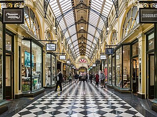
The Royal Arcade is a historic shopping arcade in the central business district of Melbourne, Victoria, Australia. Opened in 1870, it connects Bourke Street Mall to Little Collins Street, with a side offshoot to Elizabeth Street. It is the oldest surviving arcade in Australia, known for its elegant light-filled interior, and the large carved mythic figures of Gog and Magog flanking the southern entry.
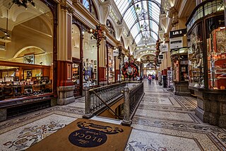
The Block Arcade is an historic shopping arcade in the central business district of Melbourne, Victoria, Australia. Constructed between 1891 and 1893, it is considered one of the late Victorian era's finest shopping arcades and ranks among Melbourne's most popular tourist attractions.
Gordon is a closed railway station, located in the town of Gordon, on the Melbourne - Ballarat railway line in Victoria, Australia. The station building is now being used by the Australian Railway Historical Society.

The Morell Bridge is an arch bridge over the Yarra River in South Yarra, Melbourne, Victoria, Australia. Completed in 1899 by John Monash and J. T. N. Anderson, it is notable as the first bridge in Victoria that was built using reinforced concrete.

The Queen's Bridge is a historic road bridge over the Yarra River in Melbourne, Victoria, Australia. The bridge was built in 1889 and has five wrought iron plate girder spans, and is listed on the Victorian Heritage Register. The bridge was built by contractor David Munro, and replaced a timber footbridge built in 1860.

The Church Street Bridge is an historic road arch bridge over the Yarra River and the Monash Freeway in Melbourne, Victoria, Australia. It links Church Street in Richmond on the north bank with Chapel Street in South Yarra on the south.

The Central Business District (CBD) of Melbourne, Australia is home to numerous lanes and arcades. Often called "laneways", these narrow streets and pedestrian paths date mostly from the Victorian era, and are a popular cultural attraction for their cafes, bars and street art.

Westgarthtown is a heritage registered precinct located within the Melbourne suburbs of Thomastown and Lalor, in Victoria, Australia.
John Beswicke (1847–1925) was an architect who practiced in Melbourne between the 1870s and 1915.

The architecture of Melbourne, the capital of the state of Victoria and second most populous city in Australia, is characterised by a wide variety of styles dating from the early years of European settlement to the present day. The city is particularly noted for its mix of Victorian architecture and modern buildings, with 52 skyscrapers in the city centre, the most of any city in the Southern Hemisphere.
The Geelong Customs House is a bluestone and freestone classical style public building in Geelong, Victoria, built in 1855. It replaced a small timber prefabricated building of 1838, which was later relocated to the Geelong Botanic Gardens.
Oakden, Addison and Kemp was an Australian architectural firm in Melbourne, Victoria. While it was short lived, existing from only 1887 to 1892, they designed a number of outstanding projects, and all three members designed many more notable projects in earlier and later partnerships.

Harbour Esplanade is a waterfront street and thoroughfare in Docklands, an inner suburb of Melbourne, Victoria, Australia. It runs roughly north-south from Navigation Drive in the south to Docklands Drive in the north. The road also forms the eastern boundary of the Victoria Harbour inlet and is adjacent to Victoria Dock.


