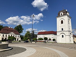
The Banská Bystrica Region is one of the eight regions of Slovakia. It is the largest of the eight regions by area, and has a lower population density than any other region. The Banská Bystrica Region was established in 1923; its borders were last adjusted in 1996. Banská Bystrica consists of 514 municipalities, 24 of which have town status. Its administrative center is the eponymous town of Banská Bystrica, which is also the region's largest town. Other important towns are Zvolen and Lučenec.

Lučenec District is a district in the Banská Bystrica Region of south-central Slovakia. Until 1918, most of the district belonged to the Novohrad county, with a small area around the villages of Šíd, Čamovce and Šurice in the east belonging to the Gemer a Malohont county.

Dunajská Streda District is a district in the Trnava Region of western Slovakia. Until 1918, the district was mostly part of the county of Kingdom of Hungary of Pozsony, apart from a small area in the south, which formed part of the county of Komárno, and Baloň, which formed part of the county of Győr. The majority of the inhabitants of Dunajská Streda District are Hungarians.
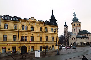
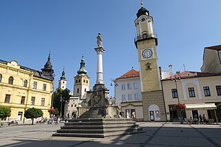
Banská Bystrica District is a district in the Banská Bystrica Region of central Slovakia. Until 1918, the area belonged to the county of Zvolen within the Kingdom of Hungary.
Brezno District is a district in the Banská Bystrica Region of central Slovakia. It was first established in 1923 and in its present borders exists from 1996.

Detva District is a district of the Banská Bystrica Region in central Slovakia. Until 1918, most of the area belonged to the Zvolen county, apart from Látky, Podkriváň and Horný Tisovník in the south and east which formed part of the county of Nógrád.

Krupina District is a district in the Banská Bystrica Region of central Slovakia. Until 1918, the district was in the county of Kingdom of Hungary Hont County.

Poltár District is a district in the south of the Banská Bystrica Region of central Slovakia. It was established in 1996. In its present borders exists from 2002, when municipalities Pinciná and Nové Hony were assigned to the Lučenec District. It is the sixth smallest district in Slovakia. Poltár District consists of 22 municipalities, from which one has a town status.

Levice District is a district in the Nitra Region of western Slovakia. It is the largest of Slovakia's 79 districts. The west of the district was in the Hungarian county of Bars until 1918, while the east of the district was in Hont County: Farná in the south was in the county of Esztergom (Ostrihom).

Bánovce nad Bebravou District is a district in the Trenčín Region of western Slovakia. Until 1918, the district was mostly part of the county of Kingdom of Hungary of Trencsén, except for a small area in the south which formed part of the county of Nyitra.

Ilava District is a district in the Trenčín Region of western Slovakia. Until 1918, the district was part of the county of Kingdom of Hungary of Trencsén.
Nové Mesto nad Váhom District is a district in the Trenčín Region of western Slovakia. Before 1920, the territory of the district was mostly part of the county of Kingdom of Hungary of Nyitra, with an area in the north forming part of the county of Trencsén.

Michalovce District is a district in the Košice Region of eastern Slovakia. Until 1918, the district was split between the county of Kingdom of Hungary of Zemplín and Uh.

Bardejov District is a district in the Prešov Region of eastern Slovakia. Until 1918, the district was part of Sáros County an administrative entity Austria-Hungary.
Humenné District is a district in the Prešov Region of eastern Slovakia. Until 1920, the district was mostly part of Zemplén (county) of the Kingdom of Hungary, apart from an area to the east of Porúbka in the Vihorlat Mountains which formed part of the county of Ung.

Komárno District is a district in the Nitra Region of western Slovakia. Until 1918, the district was mostly part of the Komárom county within the Kingdom of Hungary.

Košice I is a district in the Košice Region of eastern Slovakia, in the city of Košice. It is bordered by the Košice II, Košice III, Košice IV and Košice-okolie districts. Until 1918, the district was part of the Hungarian county of Abaúj-Torna.

Košice II is a district in the Košice Region of eastern Slovakia, in the city of Košice. It is bordered by the Košice I, Košice IV and Košice-okolie districts. Until 1920, the district was part of the Hungarian county of Abaúj-Torna.

Košice III is a district in the Košice Region of eastern Slovakia, in the city of Košice. It is bordered by the Košice I, Košice IV and Košice-okolie districts. Until 1918, the district was mostly part of the Hungarian county of Abaúj-Torna.

Košice IV is a district in the Košice Region of eastern Slovakia, in the city of Košice. It is bordered by the Košice I, Košice II, Košice III and Košice-okolie districts. Until 1918, the district was mostly part of the Hungarian county of Abaúj-Torna.

