Articles related to Algeria include:

Boumerdès is a province (wilaya) of northern Algeria, located in the Kabylia region, between Algiers and Tizi-Ouzou, with its capital at the coastal city of Boumerdès just east of Algiers.

Constantine, also spelled Qacentina or Kasantina, is the capital of Constantine Province in northeastern Algeria. During Roman times it was called Cirta and was renamed "Constantina" in honor of emperor Constantine the Great. It was the capital of the French department of Constantine until 1962. Located somewhat inland, Constantine is about 80 kilometres from the Mediterranean coast, on the banks of the Rhumel River.

At the village of Bentalha, 15 km (9.3 mi) south of Algiers, on the night of 22–23 September 1997, more than 200 villagers were killed by armed guerrillas. The number of deaths reported ranged from 85 to 400 to 417.

Laghouat is one of the forty-eight provinces (wilaya) of Algeria. It is located in the north central part of Algeria. The province borders Tiaret Province to the north, El Bayadh Province to the west, Ghardaia Province to the south and Djelfa Province to the east. The capital of the province is Laghouat City. The province is famous for palm trees and livestock.
Miliana is a commune in Aïn Defla Province in northwestern Algeria. It is the administrative center of the daïra, or district, of the same name. It is approximately 114 kilometres (71 mi) southwest of the Algerian capital, Algiers. The population was estimated at 44,201 in 2008. The town is located south of the Dahra Range, on the wooded southern flank of Mount Zaccar Rherbi, five kilometers north of the Chelif River, and overlooking the Zaccar plateau to the west.
Tariq is an Arabic word and given name.

Sidi Khaled is a town in Algeria. It is located in the province of Biskra, famous for its oasis and palms. The name of Sidi Khaled is related to the Islamic personality Khaled Ibn Sounan Elabsi.

Algiers Province is a province (wilayah) in Algeria, named after its capital, Algiers, which is also the national capital. It is adopted from the old French department of Algiers and has a population of about 3 million. It is the most densely populated province of Algeria, and also the smallest by area.

Thénia is a district in Boumerdès Province, Algeria. It was named after its capital, Thénia which, under French rule, was called Ménerville.

Béni Abbès, also known as the Pearl of the Saoura, and also as the White Oasis, is a town and commune located in western Algeria in Béchar Province, 241 km (150 mi) far from the provincial capital Béchar, and 1,200 km (746 mi) from Algiers.
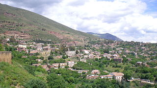
Thénia (الثنية), sometimes written as Thenia, with around 40,000 inhabitants, is the chief town in the daïra of the same name, in the wilaya of Boumerdès, in northern Algeria. Historically, the name is a contraction of Theniet Beni Aicha "the mountain pass of the sons of Aisha", the Arabic translation of the Kabyle Berber toponym Tizi n At Ɛica. The steep-sided pass, which is only about 800 metres wide at its narrowest point, is sometimes taken to mark the transition between Mitidja and Grande Kabylie.

Sidi Moussa is a commune in the Baraki District of the Algiers Province and a suburb of the city of Algiers in northern Algeria. It is situated 15 kilometers south of central Algiers.

Tazoult District is a district of Batna Province, Algeria. The capital is Tazoult, a small city of 5,000 inhabitants.

Tadmaït is a town and commune in Tizi Ouzou Province in northern Algeria, located 18 kilometers west of Tizi Ouzou and 85 kilometers est of Algiers.
Abdul-Rahman al-Tha'alibi, was an Arab Scholar, Imam and Sufi wali. He was born near the town of Isser 86 km south east of Algiers. He was raised in a very spiritual environment with high Islamic values and ethics. He had great interpersonal skills and devoted his entire life in service of the most deprived, to dhikr of Allah, and to writing of over 100 books and treatises.

Yahia Boushaki is an Algiers residential, administrative and commercial neighbourhood located in the commune of Bab Ezzouar in Kabylie.
This page is based on this
Wikipedia article Text is available under the
CC BY-SA 4.0 license; additional terms may apply.
Images, videos and audio are available under their respective licenses.

