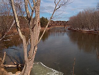
The Saco River is a river in northeastern New Hampshire and southwestern Maine in the United States. It drains a rural area of 1,703 square miles (4,410 km2) of forests and farmlands west and southwest of Portland, emptying into the Atlantic Ocean at Saco Bay, 136 miles (219 km) from its source. It supplies drinking water to roughly 250,000 people in thirty-five towns; and historically provided transportation and water power encouraging development of the cities of Biddeford and Saco and the towns of Fryeburg and Hiram. The name "Saco" comes from the Eastern Abenaki word [sɑkohki], meaning "land where the river comes out". The Jesuit Relations, ethnographic documents from the 17th century, refer to the river as Chouacoet.

Lubieszcze is a village in the administrative district of Gmina Brańsk, within Bielsk County, Podlaskie Voivodeship, in north-eastern Poland. It lies approximately 6 kilometres (4 mi) south-west of Brańsk, 29 km (18 mi) west of Bielsk Podlaski, and 52 km (32 mi) south-west of the regional capital Białystok.
Psary Witowskie is a village in the administrative district of Gmina Wolbórz, within Piotrków County, Łódź Voivodeship, in central Poland.
Wilkowice is a village in the administrative district of Gmina Wartkowice, within Poddębice County, Łódź Voivodeship, in central Poland. It lies approximately 6 kilometres (4 mi) south of Wartkowice, 5 km (3 mi) north-east of Poddębice, and 37 km (23 mi) north-west of the regional capital Łódź.
Stara Wieś is a village in the administrative district of Gmina Biała Rawska, within Rawa County, Łódź Voivodeship, in central Poland. It lies approximately 3 kilometres (2 mi) south-east of Biała Rawska, 19 km (12 mi) east of Rawa Mazowiecka, and 72 km (45 mi) east of the regional capital Łódź.
Mąchocice-Scholasteria is a village in the administrative district of Gmina Masłów, within Kielce County, Świętokrzyskie Voivodeship, in south-central Poland. It lies approximately 4 kilometres (2 mi) east of Masłów and 13 km (8 mi) east of the regional capital Kielce.
Stachura is a village in the administrative district of Gmina Mniów, within Kielce County, Świętokrzyskie Voivodeship, in south-central Poland. It lies approximately 4 kilometres (2 mi) south-west of Mniów and 18 km (11 mi) north-west of the regional capital Kielce.
Bilcza is a village in the administrative district of Gmina Morawica, within Kielce County, Świętokrzyskie Voivodeship, in south-central Poland. It lies approximately 5 kilometres (3 mi) north of Morawica and 12 km (7 mi) south of the regional capital Kielce.

Mnin is a village in the administrative district of Gmina Słupia Konecka, within Końskie County, Świętokrzyskie Voivodeship, in south-central Poland. It lies approximately 5 kilometres (3 mi) south-east of Słupia, 29 km (18 mi) south-west of Końskie, and 33 km (21 mi) west of the regional capital Kielce.
Morawy-Wicherki is a village in the administrative district of Gmina Gołymin-Ośrodek, within Ciechanów County, Masovian Voivodeship, in east-central Poland.
Mierzeniec is a village in the administrative district of Gmina Gzy, within Pułtusk County, Masovian Voivodeship, in east-central Poland.

Bury Ditches is a British Iron Age hill fort between Clun and Bishop's Castle in the Shropshire Hills of central England.
Pobratymy is a village in the administrative district of Gmina Grębków, within Węgrów County, Masovian Voivodeship, in east-central Poland.
Niewiemko is a village in the administrative district of Gmina Budzyń, within Chodzież County, Greater Poland Voivodeship, in west-central Poland. It lies approximately 12 kilometres (7 mi) south-west of Chodzież and 57 km (35 mi) north of the regional capital Poznań.
Słocina is a village in the administrative district of Gmina Kożuchów, within Nowa Sól County, Lubusz Voivodeship, in western Poland. It lies approximately 4 kilometres (2 mi) north of Kożuchów, 8 km (5 mi) west of Nowa Sól, and 20 km (12 mi) south-east of Zielona Góra.
Mańczok is a village in the administrative district of Gmina Murów, within Opole County, Opole Voivodeship, in south-western Poland. It lies approximately 19 km (12 mi) north of the regional capital Opole.
Borowo is a village in the administrative district of Gmina Kalisz Pomorski, within Drawsko County, West Pomeranian Voivodeship, in north-western Poland. It lies approximately 11 kilometres (7 mi) north-west of Kalisz Pomorski, 21 km (13 mi) south of Drawsko Pomorskie, and 80 km (50 mi) east of the regional capital Szczecin.
Puiatu is a village in Järva Parish, Järva County in central Estonia.

Talaifacene is a town and commune in Sétif Province in north-eastern Algeria.
Acholi Inn is a hotel in Gulu, the largest city in Northern Uganda.


