
The Lord's Resistance Army insurgency is a conflict involving the Lord's Resistance Army against the government of Uganda. Following the Ugandan Civil War, militant Joseph Kony formed the Lord's Resistance Army and launched an insurgency against the newly installed President Yoweri Museveni. The stated goal was to establish a Christian state based on the Ten Commandments. Currently, there is low-level LRA activity in eastern areas of the Democratic Republic of the Congo and the Central African Republic. Kony proclaims himself the 'spokesperson' of God and a spirit medium.

Juba is the capital and largest city of South Sudan. The city is situated on the White Nile and also serves as the capital of the Central Equatoria State. It is the most recently declared national capital and had a population of 525,953 in 2017. It has an area of 52 km2 (20 sq mi), with the metropolitan area covering 336 km2 (130 sq mi).

Dungu is a town in Haut-Uele Province located at the confluence of the Dungu and Kibali Rivers where they join to form the Uele River, south of the Garamba National Park. Dungu's terrain is wooded savannah, and its climate is tropical.

Magwi County, also Magwe County, is a county in Eastern Equatoria, South Sudan.
Pata, also known as Kpata, is a village in the Bamingui-Bangoran prefecture in the northern Central African Republic.

The Lord's Resistance Army (LRA) is a Christian extremist organization operating in Central Africa and East Africa. Its origins were in the Ugandan insurgency (1986–1994) against President Yoweri Museveni during which Joseph Rao Kony founded the LRA in 1987.
Tumbura, sometimes spelled Tambora or Tambura, is a town in South Sudan.
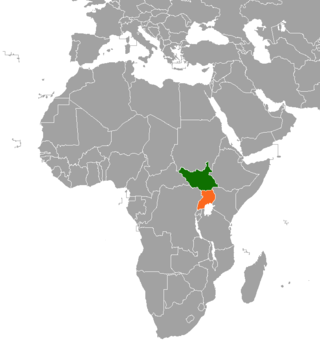
South Sudan and Uganda are neighboring states with strong cultural economic and political ties. The South Sudan and the neighbouring state of Uganda enjoy relatively strong cultural, political, and economic ties. As South Sudan neared independence, both states begun to take advantage of increased opportunities for trade, development and educational exchanges. The rebel group Lord's Resistance Army (LRA), however, continues to operate in the border areas between South Sudan, the Democratic Republic of Congo and Uganda.
Ikwoto County was an administrative area in the Eastern Equatoria state of South Sudan with headquarters in the town of Ikwoto. The people, who live in the former county's area by subsistence agriculture and cattle herding, are poverty-stricken. Years of civil war have made violence commonplace: most people have experienced the murder of a close family member. In 2009, AK-47 rifles were used in 42 per cent of killings.
Tirangore is a village in the Hiyala Payam of Torit county in the Eastern Equatoria State of South Sudan. It lies to the northeast of Torit.
Lafon is a county in Eastern Equatoria State of South Sudan. The largest town is Lafon.
Budi County is an administrative area of Eastern Equatoria state in South Sudan, with headquarters in Chukudum.
Kapoeta East County is an administrative region of Eastern Equatoria state in South Sudan, bordered by Kenya to the south, Ethiopia to the east and Jonglei state to the west. It is part of the Greater Kapoeta region of the state. The largest ethnic group is the Toposa people. The principal town is Narus. The county includes the disputed Ilemi triangle, controlled by Kenya. The emblem of the county is a horned bull, with big humps and a large tail.
Belanda Viri is a Ubangian language of South Sudan.

Morobo is one of the six counties in Central Equatoria state, South Sudan. Morobo County borders Uganda and Congo. The county is mainly occupied by Kakwa speaking people, Keliko and Lugbara. The people in Morobo are local farmers working for food. Morobo is part of the green belt and also acts as a breadbasket for Yei and Juba.
Nagero County is one of the 10 counties of Western Equatoria, a state of South Sudan
Yei River County is an administrative area in Central Equatoria with a large population of people who settled in that particular county.
Tore is an administrative area and one of the four Payams of Yei River County, Central Equatoria State, South Sudan. its located in the west of Yei and is the biggest town in the region and serves as the Administrative headquarter of Yei River It's located 48 miles maridi road with four boma of mundu, Baka,avokaya and Adio boma
Guérékindo, also spelled Guerekindo, is a village located in Mbomou Prefecture, Central African Republic. In 2010, the village received several incursions from LRA.
Source Yubu is a village located near the border of Central African Republic - South Sudan in Western Equatoria, South Sudan.
