
The Madawaska River is a river in the Saint Lawrence River drainage basin in Ontario, Canada. The river is 230 km (143 mi) long and drains an area of 8,470 km2 (3,270 sq mi). Its name comes from an Algonquian band of the region known as "Matouweskarini", meaning "people of the shallows".

The York River is a river in Renfrew County, Hastings County and Haliburton County in Ontario, Canada. The river is in the Saint Lawrence River drainage basin, and flows from the southern extension of Algonquin Provincial Park to the Madawaska River.

The Opeongo River is a river in the Saint Lawrence River drainage basin in Nipissing District in northeastern Ontario, Canada. The river is entirely within Algonquin Provincial Park and Opeongo River Provincial Park, except for a small portion around Victoria Lake, and is a left tributary of the Madawaska River.
Secondary Highway 523, commonly referred to as Highway 523, is a provincially maintained highway in the Canadian province of Ontario. The highway is a 20.1-kilometre (12.5 mi) north–south route in Nipissing District which follows the historic Madawaska Colonization Road. The highway begins at the Nipissing-Hastings boundary, where it continues south to Highway 127. It ends at Highway 60 in the village of Madawaska. The route was assumed as a provincial highway in 1956.

South Algonquin is a township municipality in Nipissing District, Ontario, Canada. Located south of Algonquin Provincial Park, it is the sole populated portion of the district that lies south of the traditional dividing line between Northern Ontario and Southern Ontario and is closer connected to Renfrew County as opposed to the core portions of Nipissing District.
Brudenell, Lyndoch and Raglan is a township in Renfrew County, Ontario, Canada. It was formed on January 1, 1999, through the merger of Brudenell and Lyndoch Township with Raglan Township.
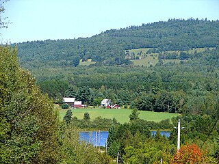
Madawaska Valley is a township in Renfrew County, Ontario, Canada. It was formed on January 1, 2001, through the amalgamation of the village of Barry's Bay and the townships of Radcliffe and Sherwood Jones & Burns.

Greater Madawaska is an incorporated township in Renfrew County in eastern Ontario, Canada, created on January 1, 2001, through the amalgamation of the Township of Bagot and Blythfield; the Township of Brougham; and the Township of Griffith and Matawatchan. As of 2011, it has a population of 2,518.
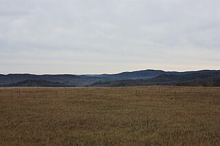
The Opeongo Hills are a range of hills in Southern Ontario, near Algonquin Provincial Park. The hills stretch from Opeongo Lake in Algonquin Park in the west, along the Madawaska and Opeongo Rivers, towards the Opeongo Colonization Road, and extending towards the Deacon Escarpment, Bonnechere, Ontario, and Dacre in the east. To the east of the Opeongo Hills lie the Madawaska River valley, the Mississippi River Valley, and the Ottawa-Bonnechere Graben along the Ottawa River. The hills continue into Quebec across the Ottawa River as the Laurentian Highlands and the Laurentian Mountains. Its tallest peak is roughly 7 km northeast of Highway 60. At roughly 586 meters, it is the tallest point in Southern Ontario. The community of Foymount is one of the highest settlements in Southern Ontario.

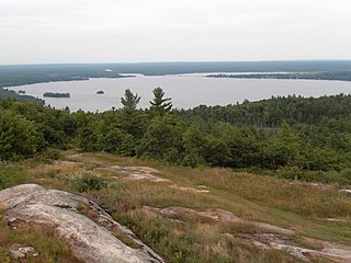
Kamaniskeg Lake is a lake in the municipalities of Hastings Highlands, Hastings County, and Madawaska Valley, Renfrew County, in Southern Ontario, Canada. It is part of the Ottawa River drainage basin and is located in the Madawaska River Valley, with nearby communities of Barry's Bay and Combermere. The lake is known for its simple beauty, with a mixture of forest, and rock and sand beaches.

Canoe Lake is a lake in the Township of Madawaska Valley in Combermere, Renfrew County, Ontario, Canada. It is 600 metres (1,969 ft) long and 300 metres (984 ft) wide, and the primary outflow is an unnamed creek to Negeek Lake on the Madawaska River.
Canoe Lake is a lake in the Township of Greater Madawaska in Renfrew County, Ontario, Canada. It is 600 metres (1,969 ft) long and 160 metres (525 ft) wide, and the primary outflow is Highland Creek, a tributary of the Madawaska River. The lake is about 9 kilometres (6 mi) north of Griffith.
Snowshoe Lake is a lake in the Madawaska River drainage basin in South Algonquin, Nipissing District, about 11.5 kilometres (7.1 mi) southeast of the community of Madawaska, and Madawaska Valley, Renfrew County, about 16 kilometres (10 mi) southwest of the community of Barry's Bay, in the province Ontario, Canada. It is about 650 metres (2,133 ft) long and 330 metres (1,083 ft) wide, and lies at an elevation of 334 metres (1,096 ft). The primary outflow is an unnamed creek to Sand Bay on the west side of Bark Lake on the Madawaska River, which flows into the Ottawa River. Only a small sliver of the lake at the northwest tip lies in South Algonquin, Nipissing District.
The Little Madawaska River is a river in the Saint Lawrence River drainage basin in the Unorganized South Part of Nipissing District in northeastern Ontario, Canada. The river is entirely within Algonquin Provincial Park, and is a right tributary of the Petawawa River and not a tributary of the nearby Madawaska River.
Black Donald Lake is a reservoir lake in the Township of Greater Madawaska, Renfrew County and the Township of North Frontenac, Frontenac County in Eastern Ontario, Canada. It is on the Madawaska River and is part of the Saint Lawrence River drainage basin.

Centennial Lake is a reservoir lake in the Township of Greater Madawaska, Renfrew County and the Township of North Frontenac, Frontenac County in Eastern Ontario, Canada. It is on the Madawaska River and is part of the Saint Lawrence River drainage basin.

Norcan Lake is a reservoir lake in the municipality of North Frontenac, Frontenac County in Eastern Ontario, Canada. It is on the Madawaska River system, is part of the Saint Lawrence River drainage basin, and is located in geographic townships of North Canonto Township and South Canonto Township.
Calabogie Lake is a reservoir lake in the municipality of Greater Madawaska, Renfrew County in Eastern Ontario, Canada. It is on the Madawaska River system, is part of the Saint Lawrence River drainage basin, and is located in the geographic townships of Bagot Township and Blythfield Township.
McKenzie Lake or Lake McKenzie may refer to:
Mud Lake is a lake in Greater Madawaska, Renfrew County in Eastern Ontario, Canada. It is in geographic Blithfield Township, and is part of the Saint Lawrence River drainage basin.

