
Mesothelioma is a type of cancer that develops from the thin layer of tissue that covers many of the internal organs. The area most commonly affected is the lining of the lungs and chest wall. Less commonly the lining of the abdomen and rarely the sac surrounding the heart, or the sac surrounding each testis may be affected. Signs and symptoms of mesothelioma may include shortness of breath due to fluid around the lung, a swollen abdomen, chest wall pain, cough, feeling tired, and weight loss. These symptoms typically come on slowly.
Koori is a demonym for Aboriginal Australians from a region that approximately corresponds to southern New South Wales and Victoria. The word derives from the Indigenous language Awabakal. For some people and groups, it has been described as a reclaiming of Indigenous language and culture, as opposed to relying on European titles such as "Aboriginal". The term is also used with reference to institutions involving Koori communities and individuals, such as the Koori Court, Koori Radio and Koori Knockout.
James Hardie Industries plc is a global building materials company and the largest global manufacturer of fibre cement products. Headquartered in Ireland, it is a dual-listed company, being listed on the Australian and New York Stock Exchanges. Its management team currently sits in Chicago, Illinois, United States. James Hardie was plagued by several asbestos-related scandals in the 20th century.

Junee is a medium-sized town in the Riverina region of New South Wales, Australia. The town's prosperity and mixed services economy is based on a combination of agriculture, rail transport, light industry and government services, and in particular correctional services. In 2021 Junee's urban population was 4,882.
CSR Limited is a major Australian industrial company, producing building products and having a 25% share in the Tomago aluminium smelter located near Newcastle, New South Wales. It is publicly traded on the Australian Securities Exchange. In 2021, it had over 3,000 employees and reported an after-tax profit of $146 million. The company has a diversified shareholding, with predominantly Australian fund managers and retail owners. The group's corporate headquarters is in North Ryde, Sydney.

Wittenoom is a former town and a declared contaminated site, 1,420 kilometres (880 mi) north-north-east of Perth, in the Hamersley Range in the Pilbara region of Western Australia. The declared contaminated site comprises 50,000 hectares, making it the largest contaminated site in the southern hemisphere.
Pambula is a town in Bega Valley Shire on the far south coast of New South Wales, Australia 454 kilometres (282 mi) south of Sydney via the Princes Highway. At the 2016 census, Pambula had a population of 970 people.

Anthony William Mundine OAM is an Australian former boxer, and one of the country's most accomplished Indigenous fighters. The only Australian boxer to compete professionally in four weight divisions, he held the Australian middleweight, light heavyweight, cruiserweight and heavyweight titles, as well as the Commonwealth middleweight and light heavyweight titles. He also challenged once for the WBA world middleweight title in 1974.

Lilydale, originally known as Upper Piper, is a small town in northern Tasmania, Australia. The town is 28 kilometres (17 mi) northeast of Launceston and is a part of the Launceston municipality, except for about 4% which is in the Dorset LGA. It is located near Mount Arthur. At the 2016 census, Lilydale had a population of 277. The town's notable attractions include the Lilydale Falls, two small waterfalls, Mount Arthur, and, along the main street, a series of telegraph poles painted with murals.
Tabulam is a rural village in the far north-east of New South Wales, Australia, 800 kilometres from the state capital, Sydney. Tabulam is located on the Bruxner Highway between Tenterfield and Casino and on the Clarence River. According to the 2016 census, there were 470 people living in Tabulam. The main village is administered by Kyogle Council, while the section of Tabulam west of the Clarence River is part of Tenterfield Shire.
Yalwal is the site of a former gold mining town of the same name situated 29 km (18 mi) west of Nowra at the confluence of the Danjera and Yarramunmun Creeks which then forms Yalwal Creek which flows into the Shoalhaven River in New South Wales, Australia.

Gilgai is a town in the Northern Tablelands region of New South Wales, Australia. The village is situated 10 km south of Inverell, New South Wales, on Thunderbolts Way, and is in Inverell Shire. At the 2006 census, Gilgai had a population of 289 people. The name Gilgai is an Aboriginal word meaning 'waterhole'.

The Bundjalung people, also spelled Bunjalung, Badjalang and Bandjalang, are Aboriginal Australians who are the original custodians of a region from around Grafton in northern coastal New South Wales to Beaudesert in south-east Queensland. The region is located approximately 550 kilometres (340 mi) northeast of Sydney and 100 kilometres (62 mi) south of Brisbane that now includes the Bundjalung National Park.

Asbestos is a group of naturally occurring, toxic, carcinogenic and fibrous silicate minerals. There are six types, all of which are composed of long and thin fibrous crystals, each fibre being composed of many microscopic "fibrils" that can be released into the atmosphere by abrasion and other processes. Inhalation of asbestos fibres can lead to various dangerous lung conditions, including mesothelioma, asbestosis, and lung cancer. As a result of these health effects, asbestos is considered a serious health and safety hazard.
Devil's Dust is a two-part Australian television docu-drama mini-series on the ABC which first screened in 2012. Based on journalist Matt Peacock's 2009 book Killer Company, Devil's Dust was researched and developed by producer Stephen Corvini for over two years prior to the series' production. Through the factual case of Bernie Banton, it recounts the tragedy of many Australian workers and their families afflicted with asbestosis and mesothelioma in the twentieth-century asbestos mining and processing industries. Though the extreme health risks of exposure to asbestos dust had been documented for many years, manufacturer James Hardie persisted in large-scale use of the material, aided by inadequate regulation by state health agencies.

The Redfern All Blacks, also known as RABs or Redfern, are an Indigenous Australian semi-professional rugby league club based in Redfern, New South Wales, They are a part of the South Sydney District Junior Rugby Football League.
The Bernie Banton Foundation was an Australian not-for-profit organisation founded in June 2009 by its CEO, Karen Banton, the widow of Bernie Banton AM. It was an Australian national mesothelioma cancer, and other asbestos related diseases victim support and patient related advocacy organisation, offering and providing support in all Australian states and territories.
Matt Peacock was an Australian television and radio journalist, correspondent and author who worked for the Australian Broadcasting Corporation in their News and Current Affairs Department specialising in politics, environment and science. He later also served as a director on the ABC Board. He authored Killer Company, a critically lauded 2009 book on the asbestos industry during that time.
The Western Bundjalung or Bundjalung people are an aggregation of tribes of Australian Aboriginal people who inhabit north-east NSW along the Clarence River, now within the Clarence Valley, Glen Innes Severn Shire, Kyogle, Richmond Valley, and Tenterfield Shire Council areas.
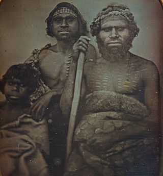
Lyall Munro Snr, also known as Uncle Lyall Munro Senior, was an Aboriginal Australian activist, leader, and elder, especially known for his advocacy of Indigenous land rights. He was the husband of Carmine "Maggie" Munro, and father of Lyall Munro Jnr.
