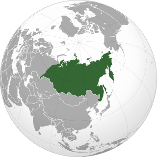
Siberia is an extensive geographical region comprising all of North Asia, from the Ural Mountains in the west to the Pacific Ocean in the east. It has formed a part of the sovereign territory of Russia and its predecessor states since the centuries-long conquest of Siberia, which began with the fall of the Khanate of Sibir in the late 16th century and concluded with the annexation of Chukotka in 1778. Siberia is vast and sparsely populated, covering an area of over 13.1 million square kilometres (5,100,000 sq mi), but home to roughly a quarter of Russia's population. Novosibirsk, Krasnoyarsk, and Omsk are the largest cities in the area.

The Baikal–Amur Mainline is a 1,520 mm broad-gauge railway line in Russia. Traversing Eastern Siberia and the Russian Far East, the 4,324 km (2,687 mi)-long BAM runs about 610 to 770 km north of and parallel to the Trans-Siberian Railway.

Yakutsk is the capital and largest city of Sakha, Russia, located about 450 km (280 mi) south of the Arctic Circle. Fueled by the mining industry, Yakutsk has become one of Russia's most rapidly growing regional cities, with a population of 355,443 at the 2021 census.

Sakha, officially the Republic of Sakha (Yakutia), is the largest republic of Russia, located in the Russian Far East, along the Arctic Ocean, with a population of one million. Sakha comprises half of the area of its governing Far Eastern Federal District, and is the world's largest country subdivision, covering over 3,083,523 square kilometers (1,190,555 sq mi). Yakutsk, which is the world's coldest major city, is its capital and largest city.
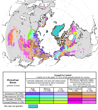
Permafrost is soil or underwater sediment which continuously remains below 0 °C (32 °F) for two years or more: the oldest permafrost had been continuously frozen for around 700,000 years. Whilst the shallowest permafrost has a vertical extent of below a meter (3 ft), the deepest is greater than 1,500 m (4,900 ft). Similarly, the area of individual permafrost zones may be limited to narrow mountain summits or extend across vast Arctic regions. The ground beneath glaciers and ice sheets is not usually defined as permafrost, so on land, permafrost is generally located beneath a so-called active layer of soil which freezes and thaws depending on the season.

The Lena is a river in the Russian Far East, and is the easternmost of the three great Siberian rivers that flow into the Arctic Ocean. The Lena is the eleventh-longest river in the world, and the longest river entirely within Russia, with a length of 4,294 km (2,668 mi) and a drainage basin of 2,490,000 km2 (960,000 sq mi). Permafrost underlies most of the catchment, 20% of which is continuous.

The woolly rhinoceros is an extinct species of rhinoceros that inhabited northern Eurasia during the Pleistocene epoch. The woolly rhinoceros was a member of the Pleistocene megafauna. The woolly rhinoceros was covered with long, thick hair that allowed it to survive in the extremely cold, harsh mammoth steppe. It had a massive hump reaching from its shoulder and fed mainly on herbaceous plants that grew in the steppe. Mummified carcasses preserved in permafrost and many bone remains of woolly rhinoceroses have been found. Images of woolly rhinoceroses are found among cave paintings in Europe and Asia. The range of the woolly rhinoceros contracted towards Siberia beginning around 17,000 years ago, with the youngest known records being around 14,000 years old in northeast Siberia, coinciding with the Bølling–Allerød warming, which likely disrupted its habitat, with environmental DNA records possibly extending the range of the species around 9,800 years ago. Its closest living relative is the Sumatran rhinoceros.

Bolshoy Lyakhovsky Island, or Great Lyakhovsky, is the largest of the Lyakhovsky Islands belonging to the New Siberian Islands archipelago between the Laptev Sea and the East Siberian Sea in northern Russia. It has an area of 5,156.6 km2 (1,991.0 sq mi), and a maximum altitude of 311 m (1,020 ft).
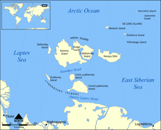
Maly Lyakhovsky Island is the second largest of the Lyakhovsky Islands belonging to the New Siberian Islands archipelago in Laptev Sea in northern Russia. It has an area of 975.5 km2 (376.6 sq mi).

The Yana is a river in Sakha in Russia, located between the Lena to the west and the Indigirka to the east.

The Yamal Peninsula is located in the Yamalo-Nenets Autonomous Okrug of northwest Siberia, Russia. It extends roughly 700 km (435 mi) and is bordered principally by the Kara Sea, Baydaratskaya Bay on the west, and by the Gulf of Ob on the east. At the northern end of this peninsula lie the Malygina Strait and, beyond it, Bely Island. Across the river lies the Gyda Peninsula. In the language of its indigenous inhabitants, the Nenets, "Yamal" means "End of the Land".

Thermokarst is a type of terrain characterised by very irregular surfaces of marshy hollows and small hummocks formed when ice-rich permafrost thaws. The land surface type occurs in Arctic areas, and on a smaller scale in mountainous areas such as the Himalayas and the Swiss Alps.
Yedoma is an organic-rich Pleistocene-age permafrost with ice content of 50–90% by volume. Yedoma are abundant in the cold regions of eastern Siberia, such as northern Yakutia, as well as in Alaska and the Yukon.

Arctic methane emissions contribute to a rise in methane concentrations in the atmosphere. Whilst the Arctic region is one of many natural sources of the greenhouse gas methane, there is nowadays also a human component to this due to the effects of climate change. In the Arctic, the main human-influenced sources of methane are thawing permafrost, Arctic sea ice melting, clathrate breakdown and Greenland ice sheet melting. This methane release results in a positive climate change feedback, as methane is a powerful greenhouse gas. When permafrost thaws due to global warming, large amounts of organic material can become available for methanogenesis and may therefore be released as methane.

Sergey Aphanasievich Zimov is a Russian geophysicist who specialises in arctic and subarctic ecology. He is the Director of Northeast Scientific Station, a senior research fellow of the Pacific Institute for Geography, and one of the founders of Pleistocene Park. He is best known for his work in advocating the theory that human overhunting of large herbivores during the Pleistocene caused Siberia's grassland-steppe ecosystem to disappear and for raising awareness as to the important roles permafrost and thermokarst lakes play in the global carbon cycle.

The Central Yakutian Lowland or the Central Yakutian Lowlands, also known as the Central Yakut Plain or the Vilyuy Lowland, is a low alluvial plain in Siberia, Russia.

Ynnakh Mountain, also known as Arga Ynnakh Khaya, Gora Ulakhan Ynnakh and as Mother Mountain, is a mountain in Verkhoyansky District, Yakutia, Russian Federation.

From June 2021, the taiga forests in Siberia and the Far East region of Russia were hit by unprecedented wildfires, following record-breaking heat and drought. For the first time in recorded history, wildfire smoke reached the North Pole.
Retrogressive thaw slumps (RTS), are a type of landslide that occur in the terrestrial Arctic's permafrost region of the circumpolar Northern Hemisphere when an ice-rich section thaws. RTSs develop quickly and can extend across several hectares modifying Arctic coastlines and permafrost terrain. They are the most active and dynamic feature of thermokarst—the collapse of the land surface as ground ice melts. They are thermokarst slope failures due to abrupt thawing of ice-rich permafrost or glaciated terrains. These horseshoe-shaped landslides contribute to the thawing of hectares of permafrost annually and are considered to be one of the most active and dynamic features of thermokarst—the "processes and landforms that involve collapse of the land surface as a result of the melting of ground ice." They are found in permafrost or glaciated regions of the Northern Hemisphere—the Tibetan Plateau, Siberia, from the Himalayas to northern Greenland, and in northern Canada's Northwest Territories (NWT), the Yukon Territories, Nunavut, and Nunavik and in the American state of Alaska. The largest RTS in the world is in Siberia—the Batagaika Crater, also called a "megaslump", is one-kilometre-long and 100 metres (330 ft) deep and it grows a 100 feet (30 m) annually. The land began to sink, and the Batagaika Crater began to form in the 1960s, following clear-cutting of a section of forested area.

Equus lenensis, the Lena horse, is an extinct species of horse from the Late Pleistocene and Holocene of Siberia, Some sources have considered it a subspecies of the wild horse.


