
Gjemnes is a municipality in Møre og Romsdal county, Norway on the Romsdal peninsula. It is part of the Nordmøre region. The administrative centre is the village of Batnfjordsøra, which lies along the Batnfjorden and it is a former steamship landing place. Other villages in Gjemnes include Torvikbukt, Flemma, Angvika, Gjemnes, Øre, and Osmarka.

Angvik or Angvika is a small village in Gjemnes Municipality in Møre og Romsdal county, Norway. The village is located along the western shores of the Tingvollfjorden, just across the fjord from the village of Tingvollvågen.

Nordmøre is a traditional district in the Norwegian county of Møre og Romsdal. The 5,426-square-kilometre (2,095 sq mi) area comprises the northern third of the county including the municipalities of Kristiansund, Averøy, Tingvoll, Surnadal, Aure, Halsa, Eide, Sunndal, Gjemnes, and Smøla. The only town in Nordmøre is Kristiansund.

Snåsavatnet is Norway's sixth-largest lake. The 122-square-kilometre (47 sq mi) lake is located in the municipalities of Steinkjer and Snåsa in Trøndelag county, Norway. The villages of Følling and Sunnan lie at the southwestern end of the lake and the village of Snåsa lies at the northeastern end of the lake. European route E6 runs along the northern shore of the lake and the Nordland Line runs along the southern shore.
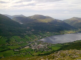
Batnfjordsøra is the administrative centre of Gjemnes Municipality in Møre og Romsdal county, Norway. The village is located at the end of the Batnfjorden at the mouth of the river Batnfjordelva. European Route E39 passes through the village on its way from Molde to Trondheim. The 0.36-square-kilometre (89-acre) village has a population (2018) of 387 and a population density of 1,075 inhabitants per square kilometre (2,780/sq mi).

Kvernesfjorden or Kvernesfjord is a fjord between the municipalities of Gjemnes, Kristiansund, Averøy, and Hustadvika in Møre og Romsdal county, Norway. The fjord is about 22 kilometres (14 mi) long.

Jølstravatnet or Jølstravatn is a lake in Sunnfjord Municipality in Vestland county, Norway. The lake empties its water into the 20-kilometre (12 mi) long Jølstra river which then flows into the Førdefjorden. The impressive eastern arm of Jølstravatn is called Kjøsnesfjorden, although it is not a true fjord that is part of the sea. The villages of Skei, Helgheim, Ålhus, and Vassenden are located on the shores of the lake.
Romsdalshalvøya, sometimes translated as the Romsdal Peninsula, is a 1,560-square-kilometre (600 sq mi) peninsula located in the Romsdal district of Møre og Romsdal county in Norway. The peninsula encompasses the western Norwegian municipalities of Molde, Gjemnes, and Hustadvika.

Øre is a small village area in Gjemnes Municipality in Møre og Romsdal county, Norway. The village is located along the Batnfjorden, about half-way between the villages of Batnfjordsøra and Torvikbukt. Øre Church is located in this village. The village of Øre was the administrative centre of the old Øre Municipality which existed from 1838 until 1965. The village is located along the County Road 666, which runs along the fjord, and the County Road 288, which runs into the surrounding Skeisdalen valley. The village is wedged in a valley between two mountains and the fjord.
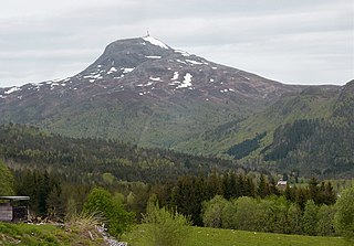
Reinsfjellet is a mountain in Gjemnes Municipality in Møre og Romsdal county, Norway. The 994-metre (3,261 ft) tall mountain is the third tallest mountain in the municipality. It is located on the Romsdal peninsula about 4 kilometres (2.5 mi) southeast of the village of Torvikbukt and the Batnfjorden. The village of Heggem lies 6.5 kilometres (4.0 mi) to the southwest and Angvika lies 10 kilometres (6.2 mi) to the southeast.
Freifjorden is a fjord in Møre og Romsdal county, Norway. The 14-kilometre (8.7 mi) long fjord flows through the municipalities of Kristiansund, Tingvoll, and Gjemnes. The fjord begins near the island of Tustna and flows southwest between the islands of Nordlandet and Frei on the west side and the mainland peninsula of Straumsnes and the islands of Aspøya and Bergsøya on the east side. The Kvernesfjorden lies at the west end of the Freifjorden, near the Freifjord Tunnel. The villages of Nedre Frei and Kvalvåg are located on the western shore of the fjord.

Tingvollfjorden is a fjord in Møre og Romsdal county, Norway. The 17-kilometre (11 mi) long fjord passes through the municipalities of Tingvoll, Gjemnes, Molde, and Sunndal. The inner part of the fjord is called the Sunndalsfjorden. The fjord begins at the island of Bergsøya and stretches about 52 kilometres (32 mi) to the village of Sunndalsøra. The river Driva flows into the fjord at its end. The fjord reaches a maximum depth of 365 metres (1,198 ft) below sea level. Villages along the fjord include Torvikbukt, Flemma, Angvika, Tingvollvågen, Rausand, Jordalsgrenda, Øksendalsøra, Hoem, and Sunndalsøra.

Flemma is a village in Gjemnes Municipality in Møre og Romsdal county, Norway. The village lies along the Tingvollfjorden, about 6 kilometres (3.7 mi) north of the village of Angvika. The mountain Reinsfjellet lies about 7 kilometres (4.3 mi) to the west. Across the fjord from Flemma is the village of Gyl in Tingvoll Municipality.
Batnfjordelva is a river in Gjemnes Municipality in Møre og Romsdal county, Norway. It originates from the lake Botnvatnet and it flows to the east and later northeast until it empties into the Batnfjorden at the village of Batnfjordsøra. The river is 19.2 kilometres (11.9 mi) long and it has a catchment of 70 square kilometres (27 sq mi). The discharge rate at the mouth of the river is 4.61 cubic metres per second (163 cu ft/s).

Lyngen is a fjord in Troms og Finnmark county, Norway. The 82-kilometre (51 mi) long fjord is the longest fjord in Troms and it is often used as the dividing line between "northern Troms" and "southern Troms". The fjord is located within the municipalities of Skjervøy, Nordreisa, Lyngen, Gáivuotna–Kåfjord, and Storfjord. It stretches from the village of Hatteng in Storfjord Municipality in the south all the way north to the islands of Skjervøy Municipality. The Lyngen Alps lie along the western shore of the fjord and the European route E06 highway runs along the eastern shore. The Kåfjorden branches off of the main fjord on the east side, and the southernmost part of the fjord is also known as the Storfjorden.
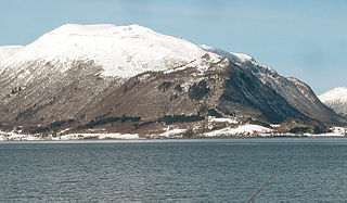
Gjemnes is a village in Gjemnes Municipality in Møre og Romsdal county, Norway. The village is located on the southern part of a small peninsula surrounded by the Kvernesfjorden to the north and the Batnfjorden to the south. The village sits along the European route E39 at the western end of the Gjemnessund Bridge (which is part of the network of bridges and tunnels that connect the town of Kristiansund to the mainland. The municipal centre of Batnfjordsøra lies about 8 kilometres to the southwest, at the end of the fjord.

Tingvollvågen or Tingvoll is the administrative centre of Tingvoll Municipality in Møre og Romsdal county, Norway. The village is located on a small inlet off the Tingvollfjorden, directly across the fjord from the village of Angvika. Tingvollvågen lies about 10 kilometres (6.2 mi) north of the village of Meisingset and about 20 kilometres (12 mi) south of the village of Straumsnes. The historic Tingvoll Church is located in this village. Norwegian National Road 70 runs through the village on its way from Kristiansund to Oppdal.
Røbekk is a village in Molde Municipality in Møre og Romsdal county, Norway. The village is located on the northern shore of the Fannefjorden, about 7 kilometres (4.3 mi) east of the town of Molde. The Årø neighborhood lies immediately to the west of Røbekk. The European route E39 highway runs through the village on its way from the town of Molde towards the village of Batnfjordsøra in Gjemnes Municipality. Røbekk Church has been located in this village since 1898.

Åkrafjorden is a fjord in Vestland county, Norway. It is located in the municipalities of Etne and Kvinnherad. The 32-kilometre (20 mi) long fjord reaches a maximum depth of 650 metres (2,130 ft). The fjord flows from the southern part of the Folgefonna National Park, draining the huge Folgefonna glacier. The fjord then flows to the southwest before emptying into the Skånevikfjorden near the village of Utåker. The Langfossen waterfall runs down the steep cliffs on the south side of the fjord, just west of Fjæra.

Øre is a former municipality in Møre og Romsdal county, Norway. The municipality existed from 1838 until its dissolution in 1965 when it was merged into Gjemnes Municipality. The 237-square-kilometre (92 sq mi) municipality was located south and west of the Batnfjorden, to the northeast of the town of Molde. The administrative centre was the village of Øre.

