
Zagreb County is a county in central Croatia. It surrounds – but does not contain – the nation's capital Zagreb, which is a separate territorial unit. For that reason, it is often nicknamed "Zagreb ring". According to the 2011 census, the county has 317,606 inhabitants.

Karlovac County is a county in central Croatia, with the administrative center in Karlovac.

Sisak-Moslavina County is a Croatian county in eastern Central Croatia and southwestern Slavonia. It is named after the city of Sisak and the region Moslavina just across the river Sava. According to 2011 census it is inhabited by 172,000 people.
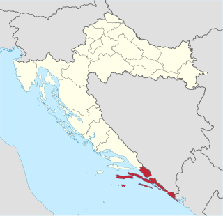
The Dubrovnik-Neretva County is the southernmost Croatian county, located in south Dalmatia. The county seat is Dubrovnik and other large towns are Korčula, Metković, Opuzen and Ploče. The Municipality of Neum, which belongs to neighbouring Bosnia and Herzegovina, divides the county in two parts.

Nova Gradiška is a city located in the Brod-Posavina County of Croatia, population 14,229 (2011). It is located in the historic region of Slavonia, near the border to Bosnia and Herzegovina.

Ploče is a town and a notable seaport in the Dubrovnik-Neretva County of Croatia.

Stara Gradiška is a village and a municipality in Slavonia, in the Brod-Posavina County of Croatia. It is located on the left bank of the river Sava, across Gradiška in Bosnia and Herzegovina. The total population is 1,363, distributed in the following settlements:

Velika Kladuša is a town and municipality located in Una-Sana Canton of the Federation of Bosnia and Herzegovina, an entity of Bosnia and Herzegovina. It is situated in the far northwest of Bosnia and Herzegovina, located near the border with Croatia. As of 2013, it has a population of 40,419 inhabitants.
Žumberak is a village and a municipality in Croatia in the Zagreb County. According to the 2011 census, there are 883 inhabitants, 98% of which are Croats. Žumberak municipality covers an area of 110 km2 (42 sq mi).
Vojnić is a municipality in Karlovac County, Croatia. There are 4,764 inhabitants, 45% of whom are Serbs and 37% of whom are Croats. The municipality is part of Kordun. Vojnić is underdeveloped municipality which is statistically classified as the First Category Area of Special State Concern by the Government of Croatia.
Žakanje is a municipality in Karlovac County, Croatia. There are 1,889 inhabitants, 97.5% of which are Croats.
Donje Dubrave is a village in Karlovac County, Croatia. It is located in the municipality of Ogulin on the old Josephine Road connecting Duga Resa and Senj. The Rijeka-Zagreb railway passes through the village. It has 250 inhabitants, most of them working on the railway in the nearby cities of Ogulin and Karlovac. There is an elementary school in the village that was attended by five students until a few years ago. The school is currently closed and the students attend school in Ogulin and Generalski Stol.
Nemetin is a village in eastern Slavonia, Croatia, located near Osijek. It has a population of 139. It is administratively located within the area of the city of Osijek.
Markovac is a village in the Slavonia region of Croatia, located east of Daruvar. The population is 80.
Gornja Slabinja is a village in the municipality of Novi Grad, Republika Srpska, Bosnia and Herzegovina.
Donja Brusovača is a village in Croatia. It is connected by the D216 highway. Croatian village, 8 kilometers from the border with Bosnia with mainly Serbian inhabitants, mainly elder people.

The Church of St. Nicholas is a Serbian Orthodox church in Rijeka, Croatia. The church is dedicated to Saint Nicholas. The building of the church was completed in 1790.
Donja Topličica is a settlement (naselje) in the Sveti Ivan Zelina administrative territory of Zagreb County, Croatia. As of 2011 it had a population of 68 people.
Križevčec is a settlement (naselje) in the Sveti Ivan Zelina administrative territory of Zagreb County, Croatia. As of 2011 it had a population of 102 people.


