Batoka Gorge Hydroelectric Power Station

Last updated
Batoka Gorge Dam
Zimbabwe relief location map.jpg
Red pog.svg
Location of Batoka Gorge Dam in Zimbabwe
Country Zambia/Zimbabwe
Coordinates 17°55′11″S26°07′51″E / 17.91972°S 26.13083°E / -17.91972; 26.13083
PurposePower
StatusProposed
Dam and spillways
Type of dam Arch gravity
Impounds Zambezi River
Height181 m (594 ft)
Width (crest)12 m (39 ft)
Width (base)97.8 m (321 ft)
Spillway capacity20,000 m3/s (710,000 cu ft/s)
Reservoir
Total capacity1,680×10^6 m3 (1,360,000 acre⋅ft)
Catchment area 508,000 km2 (196,000 sq mi)
Turbines 12 x 200 MW Francis-type
Installed capacity 2400 MW

The proposed Batoka Gorge Hydroelectric Power Station is a 2400 MW hydroelectric power station, planned for the Zambezi River on the international border between Zambia and Zimbabwe. [1]

Contents

Location

The proposed power station will be located on the Zambezi River, approximately 54 kilometres (34 mi), downstream of Victoria Falls, straddling the international border between Zambia and Zimbabwe. [2]

Overview

Currently, the proposal is for two power plants, each with an installed capacity of 1200 MW; one on the Zambian side and another on the Zimbabwean side. The dam to supply the reservoir with water will be a 181 metres (594 ft) tall arch-gravity type. [3]

The project is being implemented by the Zambezi River Authority, a bi-national organization mandated to operate, monitor and maintain the Kariba Dam complex as well as exploit the full potential of the Zambezi River. [4]

Community resistance

As in the proposal in the 1990s that was stopped, and now, again, stakeholders and the local community are strongly opposed to the dam's construction. Despite opposition, in June 2019, the Zambian and Zimbabwean governments signed a deal to build the dam with General Electric and a Chinese company, "Power China." [5] In 2023, Zambia canceled the contract, citing high costs and failure to follow proper procurement procedures. [6] In another turn of events in September 2023, UNESCO granted permission for the dam project to proceed even with critics' environmental and tourism concerns. [7]

The tourism industry generated by the current Batoka Gorge, including its whitewater rafting, employs thousands of local individuals, both directly and indirectly, and has been acknowledged as the third largest contributor to Zambia's economy. [8] Detractors of the dam have concerns about the impact on the region’s white-water rapids enterprises. Critics argue the dam poses a flooding threat to the river rapids. Zambezi whitewater rapids tours are renowned for being among the best commercially operated day and multi-day trips worldwide. [5] [9] [10] Rafting trips on the Zambezi draw thousands of global tourists annually, in both the wet and dry seasons. [9] If the proposal moves forward, the rafting industry will lose an estimated $4 million annually. [9]

The forming of a narrow, deep-water reservoir behind the dam is expected to have local ecosystem consequences. Concerns over the lake’s ability to sustain large fish populations threaten area fishing tourism. [5] [10] Some dam proponents suggest it could open up new tourism opportunities, such as parasailing and wakeboarding. However, dangerous animals like hippos and crocodiles in flat waters raise safety concerns. [11] The Zambezi basin is known for providing various ecosystem services. Constructing the dam is anticipated to have lasting effects on the region, particularly the nature tourism industry. [10]

There is some doubt that the dam will be fulfilling its stated aim of providing electricity to rural communities, as it will be connected to the Southern African Power Pool. [12] The dam could also cause the river to back up to within 650 metres of Victoria Falls, according to an article published in Zambezia. [13] This would violate the preservation boundary below the falls, which is 12 km according to UNESCO World Heritage Site agreements. [14] Thus, if the dam proposal moves forward,Victoria Falls could become a World Heritage in Danger. [15]

These perspectives are part of the ongoing debate surrounding the proposed dam and the potential consequences.

Construction costs

As of July 2018, the projected cost of development was estimated at US$4.5 billion. General Electric Africa has expressed interest in developing this power station under the design-build-operate-transfer arrangement, but with ownership reverting to Zambia and Zimbabwe, after the developers have recovered their investment plus profits. [4]

In June 2019, Bloomberg News reported that the construction contract had been awarded to a consortium comprising General Electric of the United States and Power Construction Corporation of China (PowerChina). [1] Construction is expected to take from ten to thirteen years. [16]

See also

Related Research Articles

<span class="mw-page-title-main">Kariba Dam</span> Dam in Zambia, Zimbabwe

The Kariba Dam is a double curvature concrete arch dam in the Kariba Gorge of the Zambezi river basin between Zambia and Zimbabwe. The dam stands 128 metres (420 ft) tall and 579 metres (1,900 ft) long. The dam forms Lake Kariba, which extends for 280 kilometres (170 mi) and holds 185 cubic kilometres (150,000,000 acre⋅ft) of water.

<span class="mw-page-title-main">Zambezi</span> Major river in southern Africa

The Zambezi is the fourth-longest river in Africa, the longest east-flowing river in Africa and the largest flowing into the Indian Ocean from Africa. Its drainage basin covers 1,390,000 km2 (540,000 sq mi), slightly less than half of the Nile's. The 2,574 km (1,599 mi) river rises in Zambia and flows through eastern Angola, along the north-eastern border of Namibia and the northern border of Botswana, then along the border between Zambia and Zimbabwe to Mozambique, where it crosses the country to empty into the Indian Ocean.

<span class="mw-page-title-main">Victoria Falls</span> Waterfall on the Zambezi River in Zambia and Zimbabwe

Victoria Falls is a waterfall on the Zambezi River in southern Africa, which provides habitat for several unique species of plants and animals. It is located on the border between Zambia and Zimbabwe and is one of the world's largest waterfalls, with a width of 1,708 m (5,604 ft).

<span class="mw-page-title-main">Livingstone, Zambia</span> Place in Southern Province, Zambia

Livingstone is a city in Zambia. Until 1935, it served as the capital of Northern Rhodesia. Lying 10 km (6 mi) to the north of the Zambezi River, it is a tourism attraction center for the Victoria Falls and a border town with road and rail connections to Zimbabwe on the other side of the Victoria Falls. A historic British colonial city, its present population was enumerated at 177,393 inhabitants at the 2022 census. It is named after David Livingstone, the Scottish explorer and missionary who was the first European to explore the area. Until 2011, Livingstone was the provincial capital of Zambia's Southern Province.

<span class="mw-page-title-main">Victoria Falls, Zimbabwe</span> Resort City in Matabeleland North, Zimbabwe

Victoria Falls, popularly known as Vic Falls, is a resort town and city in the province of Matabeleland North, Zimbabwe. It lies on the southern bank of the Zambezi River at the western end of Victoria Falls themselves. According to the 2022 Population Census, the town had a population of 35,199.

<span class="mw-page-title-main">Mana Pools National Park</span> UNESCO World Heritage Site

Mana Pools National Park is a 219,600-hectare (543,000-acre) wildlife conservation area and national park in northern Zimbabwe. It is a region of the lower Zambezi in Zimbabwe where the floodplain turns into a broad expanse of lakes after each rainy season. As the lakes gradually dry up and recede, the region attracts many large animals in search of water, making it one of Africa's most renowned game-viewing regions.

<span class="mw-page-title-main">Mosi-oa-Tunya National Park</span> National park in Zambia

Mosi-oa-Tunya National Park is a UNESCO World Heritage Site that is home to one-half of the Mosi-oa-Tunya—"The Smoke that Thunders", known worldwide as Victoria Falls—on the Zambezi River. The river forms the border between Zambia and Zimbabwe, so the falls are shared by the two countries, and the park is twin to the Victoria Falls National Park on the Zimbabwean side.

<span class="mw-page-title-main">Kazungula</span> Human settlement in Zambia

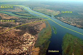
Kazungula is a small border town in Zambia, lying on the north bank of the Zambezi River about 70 kilometres (45 mi) west of Livingstone on the M10 Road.

<span class="mw-page-title-main">Taita falcon</span> Species of bird

The Taita falcon is a small falcon found in central and eastern Africa. It was first described from the Taita Hills of Kenya from which it derives its name.

<span class="mw-page-title-main">Lusaka–Livingstone Road</span> Road in Zambia

The T1 or Lusaka–Livingstone Road is the main highway of the Southern Province of Zambia. It begins 55 kilometres south of the city of Lusaka and heads south-west to the principal tourist destination, Victoria Falls in Livingstone, via Mazabuka, Monze, Choma and Kalomo, measuring approximately 430 kilometres (267 mi). The entire route is part of Trans-African Highway network number 4 or Cairo-Cape Town Highway between Cairo and Cape Town.

Zimbabwe Electricity Supply Authority, (ZESA) whose official name is ZESA Holdings (Private) Limited, is a state-owned company whose task is to generate, transmit, and distribute electricity in Zimbabwe.

Operation Noah was a wildlife rescue operation on the Zambezi River, lasting from 1958 to 1964. In the late 1950s, North and South Rhodesia constructed the Kariba Dam hydroelectric power station across the Zambezi River, at the Kariba Gorge, about 400 km from Victoria Falls. The Kariba Dam mostly provided electric power to both countries, created Lake Kariba, the world's largest man-made lake, and flooded the Kariba Gorge - home to thousands of native animals and the local Tonga people. In a wildlife rescue operation lasting 5 years, over 6000 animals were rescued and relocated to the mainland.

The Kafue Gorge Upper Power Station (KGU), is an operational 900 megawatts (1,206,920 hp) hydroelectric power plant across the Kafue River in Zambia.

<span class="mw-page-title-main">Livingstone District</span> District in Southern Province, Zambia

Livingstone District is a district of Zambia, located in Southern Province. The capital lies at Livingstone, Zambia. As of the 2000 Zambian Census, the district had a population of 103,288 people. Its border with Zimbabwe is formed by the Zambezi River and Victoria Falls. Although most people live in Livingstone, other villages include Jinga Jinga in the north and Simonga in the southwest.

Mphanda Nkuwa Dam is a proposed hydroelectric dam on the Zambezi River in Mozambique. The dam would be located about 60 kilometres (37 mi) downstream of the existing Cahora Bassa Dam near the city of Tete. Its power station would have a capacity of 1,500 megawatts.

Kafue may refer to:

<span class="mw-page-title-main">T2 road (Zambia)</span> Road in Zambia

The T2 is a trunk road in Zambia. The road runs from the Tunduma border with Tanzania via Mpika, Kabwe and Lusaka to the Chirundu border with Zimbabwe. The road is the longest route of the country, as it is approximately 1,155 kilometres (718 mi). The route from Mpika to Kafue is a toll road. The route from Tanzania to Lusaka is Zambia's Great North Road and is part of the Tanzam Highway.

Kafue Gorge Lower Power Station (KGL), is a 750 megawatts (1,010,000 hp) hydroelectric power station in Zambia.

<span class="mw-page-title-main">Power Construction Corporation of China</span>

Power Construction Corporation of China, branded as PowerChina, is a wholly State-owned company administered by the State-owned Assets Supervision and Administration Commission and part of the heavy and civil engineering construction industry. PowerChina consists of 779 companies. In 2020, PowerChina ranked 157 among Fortune Global 500 companies and 41 among Top 500 Enterprises of China.

References

  1. 1 2 Matthew Hill, and Prinesha Naidoo (21 June 2019). "GE, PowerChina Set to Build $4 Billion Zambia-Zimbabwe Plant". Bloomberg.com . Retrieved 22 June 2019.
  2. Lusaka Times Staff (27 September 2013). "Construction of Dam for Batoka Gorge hydroelectric power stations to start next year". Lusaka Times. Lusaka. Retrieved 10 July 2018.
  3. COMESA (7 March 2014). "Batoka Gorge Hydro-Power Project Profile" (PDF). Common Market for Eastern and Southern Africa (COMESA). Archived from the original (Archived from the Original) on 7 March 2014. Retrieved 9 July 2018.
  4. 1 2 Mukarati, Levi (9 July 2018). "$4.5 Billion Batoka Deal to Create 6,000 Jobs". The Zimbabwe Herald . Harare. Retrieved 10 July 2018.
  5. 1 2 3 "Save the Zambezi – Batoka Gorge threatened by huge dam - International Rafting Federation". 2020-04-16. Retrieved 2023-12-03.
  6. Okafor, Chinedu (2023-06-15). "Zambia cancels $5 billion project with China, see why". Business Insider Africa. Retrieved 2023-12-03.
  7. Okafor, Chinedu (October 17, 2023). "The controversial $5 billion project between Zambia and Zimbabwe has received approval from the UN". www.msn.com. Retrieved 2023-12-03.
  8. "The Zambezi River: Threatened Paddling Classics #7". Canoe & Kayak Magazine. 2015-03-10. Retrieved 2017-04-12.
  9. 1 2 3 "Save the Zambezi – Batoka Gorge threatened by huge dam - International Rafting Federation". 2020-04-16. Retrieved 2023-12-03.
  10. 1 2 3 "Batoka Gorge Dam". www.victoriafalls-guide.net. Retrieved 2023-12-03.
  11. "Massive Dam Threatens Spectacular Gorge Downstream of Victoria Falls". Earth Island Journal. Retrieved 2023-12-03.
  12. "Batoka Gorge Hydroelectric Power Station". NS Energy. Retrieved 16 March 2024.
  13. "Latest Update on the Batoka Dam Project | VictoriaFalls24". victoriafalls24.com. Retrieved 2017-04-12.
  14. Centre, UNESCO World Heritage. "Mosi-oa-Tunya / Victoria Falls". whc.unesco.org. Retrieved 2017-04-12.
  15. Centre, UNESCO World Heritage. "World Heritage in Danger". whc.unesco.org. Retrieved 2017-04-12.
  16. Jean Marie Takouleu (25 June 2019). "Zambia/Zimbabwe: GE And Power China To Build Batoka Gorge Dam". Afrik21.africa. Paris, France. Retrieved 28 August 2021.