
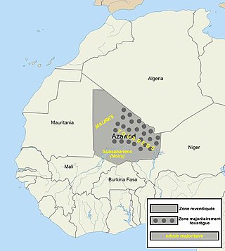
Azawad, or Azawagh, was a short-lived unrecognised state lasting between 2012 and 2013. Azawagh (Azawaɣ) is the generic Tuareg Berber name for all Tuareg Berber areas, especially the northern half of Mali and northern and western Niger. The Azawadi declaration of independence was declared unilaterally by the National Movement for the Liberation of Azawad (MNLA) in 2012, after a Tuareg rebellion drove the Malian Armed Forces from the region.
The 2012 Tuareg rebellion was the early phase of the Mali War; from January to April 2012, a war was waged against the Malian government by rebels with the goal of attaining independence for the northern region of Mali, known as Azawad. It was led by the National Movement for the Liberation of Azawad (MNLA) and was part of a series of insurgencies by traditionally nomadic Tuaregs which date back at least to 1916. The MNLA was formed by former insurgents and a significant number of heavily armed Tuaregs who fought in the Libyan Civil War.
The National Movement for the Liberation of Azawad or the Azawad National Liberation Movement, formerly the National Movement of Azawad, is a militant organization based in northern Mali.

Ansar Dine, meaning "helpers of the religion" (Islam) and also known as Ansar al-Din, was a Salafi jihadist group led by Iyad Ag Ghaly. Ansar Dine sought to impose absolute sharia across Mali. The group took over the city of Timbuktu in 2012, which prompted the French-led intervention, Operation Serval.
Iyad Ag Ghaly, also known as Abū al-Faḍl, is a Tuareg Islamist militant from Mali's Kidal Region. He has been active in Tuareg rebellions against the Malian government since the 1980s – particularly in the early 1990s. In 1988, he founded the Popular Movement for the Liberation of Azawad. In the latest episode of the Tuareg upheavals in 2012, he featured as the founder and leader of the Islamist militant group Ansar Dine.

The Battle of Gao was fought between the National Movement for the Liberation of Azawad (MNLA) and the Islamist Movement for Oneness and Jihad in West Africa (MOJWA), along with its ally Ansar Dine, in Gao between 26–28 June 2012. By the 28 June, Gao, Timbuktu and Kidal, the three biggest cities in the disputed secessionist region of Azawad within what is recognised as Malian territory, were under the control of Ansar Dine and its Islamist allies.

The Mali War is an ongoing conflict that started in January 2012 between the northern and southern parts of Mali in Africa. On 16 January 2012, several insurgent groups began fighting a campaign against the Malian government for independence or greater autonomy for northern Mali, which they called Azawad. The National Movement for the Liberation of Azawad (MNLA), an organization fighting to make this area of Mali an independent homeland for the Tuareg people, had taken control of the region by April 2012.

The Second Battle of Ménaka was the last battle fought by the state of Azawad, as they were defeated by an Islamist coalition.
The Battle of Aguelhok occurred when rebels from the National Movement for the Liberation of Azawad (MNLA) and Islamists groups Ansar Dine and Al-Qaeda in the Islamic Maghreb attacked a Malian army garrison base in the town of Aguelhok, Kidal Region of Northern Mali on 17 January 2012, as part of the larger Tuareg rebellion to seize all government bases in the region.
The siege of Tessalit occurred in early 2012 during the Tuareg rebellion in Mali. Amachach military base, located in Tessalit, was defended by roughly 800 Malian soldiers commanded by Colonel Kassim Goita. The International Committee of the Red Cross was sent to help evacuate civilians and military families, but despite the approval of the National Movement for the Liberation of Azawad (MNLA), Malian authorities delayed the operation and it was never executed as a humanitarian source. Other Malian military forces in the region of Tessalit were led by Colonels' Didier Dacko, Ould Meydou, and the well respected Tuareg commander El Hadji Ag Gamou.

The Battle of Konna was a battle in the Northern Mali Conflict in the town of Konna in central Mali. Various Islamic fundamentalist rebels fought with the government of Mali, the latter of which was supported by French soldiers participating in Operation Serval. This battle was among the first French engagements in their intervention in the Mali War.

The Battle of Diabaly was fought between government forces of Mali, against groups of Islamists militants such as the AQIM and Ansar Dine. The Islamists held control of Diabaly for no longer than a week until Malian forces with the help French air strikes recaptured the town.

The following is a timeline of major events during the Northern Mali conflict.
The Battle of In Khalil took place on 22–23 February 2013 and was part of the first stage of the Mali War.
The First Battle of Menaka is an attack led on January 17, 2012, by armed groups of the National Movement for the Liberation of Azawad (MNLA) and marks the beginning of the Tuareg rebellion of 2012. This is the first in a series of battles aimed a capturing most of the north Mali from the army by the rebels.
The Ambush of Tin-Hama took place during the Tuareg rebellion of 2012, on March 25, 2012, when a convoy of the Ganda Izo militia was ambushed by the MNLA.
The ambush of Tinsalane occurred on February 11, 2012, when armed groups of Ansar Dine and the National Movement for the Liberation of Azawad (MNLA) fought against a convoy of the Malian army who came to reinforce the troops besieged in Tessalit.
The first battle of Kidal took place during the Mali war. On 30 March 2012, the city was captured by rebel MNLA and Ansar Dine forces.
Between December 24–25, 2015, Ansar Dine militants attacked National Movement for the Liberation of Azawad (MNLA) positions in Talahandak, Mali. Ansar Dine captured the MNLA outpost, and then ambushed CMA reinforcements.
Hamada Ag Hama, also known as Abdelkrim Taleb or Abdelkrim al-Targui was a Malian jihadist and emir of Katiba Al Ansar, a brigade in Al-Qaeda in the Islamic Maghreb (AQIM).
