
Beckenham is a town in Greater London, England, within the London Borough of Bromley. Until 1965 it was part of the historic county of Kent. It is located 8.4 miles (13.5 km) south-east of Charing Cross, situated north of Elmers End and Eden Park, east of Penge, south of Lower Sydenham and Bellingham, and west of Bromley and Shortlands. Its population at the 2011 census counted 46,844 inhabitants.
Northolt is a town in West London, England, spread across both sides of the A40 trunk road. It is 11 mi (17.7 km) west-northwest of Charing Cross and is one of the seven major towns that make up the London Borough of Ealing. It had a population of 30,304 at the 2011 UK census.

Harold Hill is a suburban area in the London Borough of Havering, East London. 16.6 miles (26.7 km) northeast of Charing Cross. It is a district centre in the London Plan. The name refers to King Harold II, who held the manor of Havering-atte-Bower, and who was killed at the Battle of Hastings in 1066. The suburb is peripheral to London, forming an eastern edge of the urban sprawl.
Gamesley is a residential area within the Borough of High Peak in Derbyshire, England, west of Glossop and close to the River Etherow which forms the boundary with Tameside in Greater Manchester. Gamesley is a ward of the High Peak Borough Council. It had a population of 2,531 at the 2011 Census.
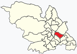
Manor Castle ward—which includes the districts of Claywood, Manor, Manor Park, Park Hill, and Wybourn—is one of the 28 electoral wards in City of Sheffield, England. It is located in the eastern part of the city and covers an area of 5.4 km2 (2.08 mi2). The population of this ward in 2001 was 21,000 people in 9,700 households, the population increasing to 21,223 at the 2011 Census. It is one of the wards that make up the Sheffield Central constituency.

Aston is an area of inner Birmingham, England. Located immediately to the north-east of Central Birmingham, Aston constitutes a ward within the metropolitan authority. It is approximately 1.5 miles from Birmingham City Centre.

Barking is a town in East London, England, within the London Borough of Barking and Dagenham. It is 9.3 miles (15 km) east of Charing Cross. The total population of Barking was 59,068 at the 2011 census. In addition to an extensive and fairly low-density residential area, the town centre forms a large retail and commercial district, currently a focus for regeneration. The former industrial lands to the south are being redeveloped as Barking Riverside.

Alford is a town in the East Lindsey district of Lincolnshire, England, at the foot of the Lincolnshire Wolds, which form an Area of Outstanding Natural Beauty. The population was recorded as 3,459 in the 2011 Census and estimated at 3,830 in 2021. It lies between the towns of Mablethorpe, Louth, Spilsby, and Skegness and acts as a local retail centre.
Kingsthorpe is a suburb and civil parish of Northampton, England. It is situated to the north of Northampton town centre and is served by the A508 and A5199 roads which join at Kingsthorpe's centre. The 2011 Census recorded the population of the district council ward as 4,477.

Rawdon is a village and civil parish in the metropolitan borough of the City of Leeds, West Yorkshire, England. It sits on the River Aire and on the A65 south of Yeadon.

Cheltenham is a constituency in Gloucestershire represented in the House of Commons of the UK Parliament since 1832. As with all constituencies, it elects one Member of Parliament (MP) by the first past the post system of election at least every five years. Since 2015, its MP has been Alex Chalk, who was appointed Secretary of State for Justice in 2023.

Northleach is a market town and former civil parish, now in parish Northleach with Eastington, in the Cotswold district, in Gloucestershire, England. The town is in the valley of the River Leach in the Cotswolds, about 10 miles (16 km) northeast of Cirencester and 11 miles (18 km) east-southeast of Cheltenham. The 2011 Census recorded the parish's population as 1,854, the same as Northleach built-up-area.

Trentham is a suburb of the city of Stoke-on-Trent in North Staffordshire, England, south-west of the city centre and south of the neighbouring town of Newcastle-under-Lyme. It is separated from the main urban area by open space and by the Trent and Mersey Canal and the River Trent, giving it the feel of a village.

Southborough is a town and civil parish in the borough of Tunbridge Wells in Kent, England. It lies immediately to the north of the town of Tunbridge Wells and includes the district of High Brooms, with the A26 road passing through it. According to the 2001 census it had a population of 11,124. The town is within the High Weald Area of Outstanding Natural Beauty.
Half of Cheltenham Borough Council is the local authority for Cheltenham in Gloucestershire, England. Half the council is elected every two years, while before 2002 the council was elected by thirds. Since the last boundary changes in 2002, 40 councillors have been elected from 20 wards.
Rowanfield is a neighbourhood in Cheltenham, England. It consists primarily of a social housing estate of Wimpey no-fines houses and low-rise flats, built around 1953, with Rowanfield School and a playing field to the West separating it from Hesters Way and also the older Rowanfield Road to the East. To the south-west Rowanfield borders the district of St Mark's. Rowanfield is located 1.5 miles west of the centre of Cheltenham.

Wragby is a town and civil parish in the East Lindsey district of Lincolnshire, England. It is situated at the junction of the A157 and A158 roads, and approximately 10 miles (16 km) north-west from Horncastle and about 11 miles (18 km) north-east of Lincoln.
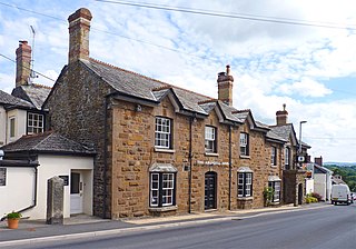
Lifton is a village and civil parish in Devon, South West England near the confluence of the rivers Wolf and Lyd, 1¼ miles south of the A30 trunk road and very near the border between Devon and Cornwall. The village is part of the electoral ward of Thrushel. The population of the surrounding Thrushel ward at the 2011 census was 1680.

Cowley is a village and civil parish in the Cotswold District of Gloucestershire, England. It lies between the A417 and A435 roads between Cheltenham and Cirencester in the Churn Valley, and has a population of 333. The name originates from 'cow' and 'leigh', literally meaning cow pasture.


