A nature reserve is a protected area of importance for flora, fauna, or features of geological or other special interest, which is reserved and managed for purposes of conservation and to provide special opportunities for study or research. They may be designated by government institutions in some countries, or by private landowners, such as charities and research institutions. Nature reserves fall into different IUCN categories depending on the level of protection afforded by local laws. Normally it is more strictly protected than a nature park. Various jurisdictions may use other terminology, such as ecological protection area or private protected area in legislation and in official titles of the reserves.
Ezemvelo KZN Wildlife is a governmental organisation responsible for maintaining wildlife conservation areas and biodiversity in KwaZulu-Natal Province, South Africa. Their headquarters is in Queen Elizabeth Park situated on the northern slopes of Pietermaritzburg, the KwaZulu-Natal provincial capital. Prior to 1994, it was known as the Natal Parks Board.

The Sundarbans National Park is a national park, tiger reserve and biosphere reserve in West Bengal, India. It is part of the Sundarbans on the Ganges Delta and adjacent to the Sundarban Reserve Forest in Bangladesh. It is located to south-west of the Bangladesh. The delta is densely covered by mangrove forests, and is one of the largest reserves for the Bengal tiger. It is also home to a variety of bird, reptile and invertebrate species, including the salt-water crocodile. The present Sundarban National Park was declared as the core area of Sundarban Tiger Reserve in 1973 and a wildlife sanctuary in 1977. On 4 May 1984 it was declared a national park. It is a UNESCO World Heritage Site inscribed in 1987, and it has been designated as a Ramsar site since 2019. It is considered as a World Network of Biosphere Reserve from 1989.

Sundarbans is a mangrove area in the delta formed by the confluence of the Ganges, Brahmaputra and Meghna Rivers in the Bay of Bengal. Sundarban Reserve Forest (SRF) of Bangladesh is the largest mangrove forest in the world. It spans the area from the Baleswar River in Bangladesh's division of Khulna to the Hooghly River in India's state of West Bengal. It comprises closed and open mangrove forests, land used for agricultural purpose, mudflats and barren land, and is intersected by multiple tidal streams and channels. Sundarbans is home to the world's largest area of mangrove forests. Four protected areas in the Sundarbans are enlisted as UNESCO World Heritage Sites, viz. Sundarbans West (Bangladesh), Sundarbans South (Bangladesh), Sundarbans East (Bangladesh) and Sundarbans National Park (India).

The Towra Point Nature Reserve is a protected nature reserve that is located in Sutherland Shire, southern Sydney, New South Wales, in eastern Australia. The 603-hectare (1,490-acre) reserve is situated on the southern shores of Botany Bay at Kurnell, within the Sutherland Shire. The reserve is protected under the Ramsar Convention as a wetland of international importance as an important breeding ground for many vulnerable, protected, or endangered species. The Towra Point Aquatic Nature Reserve is located in the surrounding waterways.

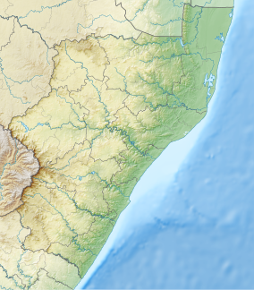
Durban North is an area to the north of Durban in the eThekwini Metropolitan Municipality, KwaZulu-Natal, South Africa. Durban North lies between the N2 freeway and the eastern seashore, with the Umgeni River forming its southern boundary. It has residential suburbs that are some of Durban's most affluent and is flanked by La Lucia in the north.

Dongzhai Port Nature Reserve, also called the Hainan Dongzhai Bay National Nature Reserve, Dongzhai Harbor Mangrove, and Dongzhai Harbor Mangrove Natural Reserve Area, is located within Dongzhai Harbor, in the area of Yanfeng Town, Meilan District, Haikou, Hainan, China. It has an area of 2,500 hectares and includes six rivers. The coastline is very irregular and includes a number of bays and tidewater gullies. The mangrove forest on the south coast provides a habitat for birds and other wildlife.
The Aguirre State Forest is a 2,393-acre (9.68 km2) nature reserve on the south coast of Puerto Rico and one of the commonwealth's 20 state forests. It mainly consists of mangroves and floodplain forests, and it borders the Jobos Bay National Estuarine Research Reserve. The Aguirre State Forest is owned and administered by Puerto Rico. It was established in 1918 by Puerto Rico governor Arthur Yager to protect the mangrove forests areas between the municipalities of Guayama and Santa Isabel.
The Southern Africa mangroves are mangrove ecoregion on the Mozambique's southernmost coast and the eastern coast of South Africa.

Pigeon Valley is a Natural Heritage Park and formally declared municipal nature reserve in Durban, South Africa. It is an unusual example of an urban reserve with very high levels of biodiversity. It was established to provide protection for the Natal elm and other forest giants of the coastal climax forest. Another rare tree that occurs here is Natal forest loquat, which is endemic to the Durban area and to oNgoye Forest.
Palmiet Nature Reserve is located in Westville, a town located ten kilometres from Durban, South Africa. The reserve is made up of a wide variety of natural habitats ranging from forests to grassland. Hundreds of bird species have been recorded and the tree list is extensive. There are a number of self-guided trails that include river crossings. The diversity seen in the Palmiet Nature Reserve has been extensively threatened by human activity and invasive species, leading to the need for more pronounced guidelines on how to protect and reserve the area.
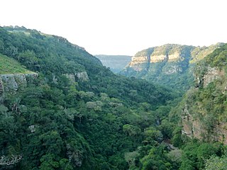
The Krantzkloof Nature Reserve, managed by Ezemvelo KZN Wildlife, conserves 668 ha of the Molweni and Nkutu River gorges that incise the sandstone Kloof plateau in KwaZulu-Natal, South Africa. The reserve conserves coastal scarp forest, sourveld grassland, a cliff face biotope, and aquatic environments along its rivers. Scarp forest is a threatened forest type, protected by South Africa's forests act of 1998, while the grassland is classified as KwaZulu-Natal sandstone sourveld, the most threatened terrestrial habitat in the Durban metropole. The reserve was established in 1950 and was augmented by land donations as late as 1999.

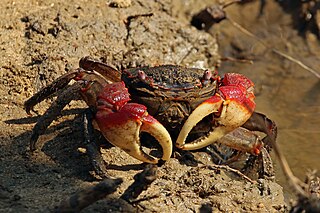
Beachwood Mangroves Nature Reserve is located at the mouth of the Umgeni River in Durban North, a suburb of Durban, South Africa. The nature reserve, proclaimed in 1977, protects 76 hectares of a natural estuarine system, and was declared a national monument in 1980.
Virginia Bush Nature Reserve is a 38 hectare coastal bush reserve in the suburb of Durban North, Durban, South Africa. The reserve is currently under the auspices of the Durban Metropolitan Open Space System (D'MOSS).
Yellowwood Park is a quiet suburb of the city of Durban, South Africa, established in 1960. It is 14 km southwest of central Durban.

Bluff Nature Reserve is a 45 hectare protected pan and forest in the suburb of The Bluff, Durban, South Africa. The park was proclaimed in 1974, making it Durban's oldest nature reserve, and is managed by Ezemvelo KZN Wildlife.
North Park Nature Reserve is a protected area along the banks of the Umhlatuzana River, near Queensburgh in KwaZulu-Natal, South Africa. The park was proclaimed in 1968 and is managed by Ezemvelo KZN Wildlife.
New Germany Nature Reserve is a protected area of coastal grassland and forest overlooking the suburb of New Germany outside of Pinetown, KwaZulu-Natal, South Africa. The reserve consists of a nature park featuring a walk-through aviary and snake display, and grasslands to the south of the park which can be explored by foot.

Caño Martín Peña Nature Reserve is a nature reserve in San Juan, Puerto Rico located along the 3.75 mile long Martín Peña Channel. The nature reserve protects wetlands and an urban mangrove forest which extends throughout the channel between the Los Corozos and San José Lagoons in the east and the San Juan Bay in the west, and between the districts of Santurce in the north and Hato Rey in the south. This reserve is managed by the Puerto Rico Department of Natural and Environmental Resources (DRNA) and belongs to the larger San Juan Bay National Estuary, the only tropical estuary in the National Estuary Program network.