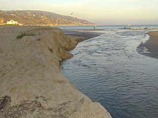
uMhlanga Lagoon is a 26 hectares (64 acres)nature reserve on the shore of the Indian Ocean at uMhlanga Rocks, South Africa.[1] The reserve encloses the Ohlanga River's lagoon and mouth.[2] The forest forms a natural extension of the less accessible Hawaan Forest, of which the greater part lies inland of the busy M4 road. The reserve trails start at a car park at the northern end of Lagoon Drive, uMhlanga.
The reserve has picnic sites, the remains of a prehistoric shell midden[3] and walking trails,[2] with a walkway and pedestrian bridge that span the lagoon.
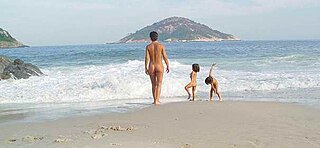
At the mouth of the Ohlanga lagoon, there is a popular but unofficial nudist beach.[4][5][6] Increased use of the area by non-nudist walkers and families resulted in complaints about nudism and antisocial behaviour.[7] The area was at one time a ‘no-go’ area, due to a serious crime problem.[7]
Beater, B. E.; Maud, R. R. (Apr 1963). "The Occurrence of a Coastal Midden near Umhlanga Rocks, Natal". The South African Archaeological Bulletin. South African Archaeological Society. 18 (69): 21–23. JSTOR3887491.
Murramarang is a national park in New South Wales, Australia, 206 km (128 mi) southwest of Sydney. It follows the coastline from Long Beach north to Merry Beach near Ulladulla. It is surrounded by three state forests, Kioloa, South Brooman, and Benandarrah. The park forms part of the Ulladulla to Merimbula Important Bird Area, identified as such by BirdLife International because of its importance for swift parrots.
eMdloti, alternatively rendered Umdloti and also known as Umdloti Beach, is a small resort village situated along the KwaZulu-Natal North Coast, South Africa. It lies at the mouth of the Mdloti River approximately 24 km north-east of Durban and 11 km north-east of uMhlanga and now forms part of eThekwini, the Greater Durban Metropolitan Municipality.
Lobamba is a city in Eswatini, and is one of the two capitals, serving as the legislative, traditional, spiritual, seat of government of the Parliament of Eswatini, and Ludzidzini Royal Village, the residence of Queen Ntfombi, the Queen Mother.
The Canaveral National Seashore (CANA) is a National Seashore located between New Smyrna Beach and Titusville, Florida, in Volusia and Brevard Counties. The park, located on a barrier island, was created on January 3, 1975, by an act of Congress. The park is split between Brevard and Volusia counties, with 9 miles of the seashore in Brevard County, and 15 miles of the seashore in Volusia County. CANA consists of 24 miles of beaches, dunes, mangrove wetlands, and a large portion of the Mosquito Lagoon. The Canaveral National Seashore is also the longest expanse of undeveloped land along the East Coast of Florida. The Canaveral National Seashore is home to more than 1,000 plant species and 310 bird species. CANA occupies 57,662 acres (23,335 ha). There are 3 major beach sections in the seashore. The southern section is Playalinda Beach, the middle section is Klondike Beach, and the northern section is Apollo Beach.
Malibu Lagoon State Beach in Malibu, California, United States, is also known as Surfrider Beach. It was dedicated as the first World Surfing Reserve on October 9, 2010. The 110-acre (45 ha) site was established as a California state park in 1951. It lies within the Santa Monica Mountains National Recreation Area.
The Ohlanga River is a river in KwaZulu-Natal, South Africa, which empties into the Indian Ocean just north of uMhlanga, north of Durban. The river has extensive reed beds in the estuary at its mouth, which is only 7 km southwest from the mouth of the Mdloti River. Presently, this river is part of the Mvoti to Umzimkulu Water Management Area.
Durban North is an area to the north of Durban in the eThekwini Metropolitan Municipality, KwaZulu-Natal, South Africa. Durban North lies between the N2 freeway and the eastern seashore, with the Umgeni River forming its southern boundary. It has residential suburbs that are some of Durban's most affluent and is flanked by La Lucia in the north.
Sandy Bay is a nudist beach just south of Llandudno. It is on the west side of the Karbonkelberg, and cannot be seen from the main road to Hout Bay, which turns inland above Llandudno.
uMhlanga, alternatively rendered Umhlanga, is a residential, commercial and resort town north of Durban on the coast of KwaZulu-Natal, South Africa. It is part of the eThekwini Metropolitan Municipality, which was created in 2000 and includes the greater Durban area. The name means "place of reeds" in the Zulu language, and the correct pronunciation of "hl" in uMhlanga is similar to the Welsh "ll".
Cable Beach is a 22 km (14 mi) stretch of white sand beach on the eastern Indian Ocean and the name of the surrounding suburb in Broome, Western Australia. Cable Beach was named after the telegraph cable laid between Broome and Java in 1889. Low cliffs of red ochre rise behind the very flat and wide beach, with waves that are mostly gentle in the dry season from May to October. In 2016, the population was 5,436.
A nude beach, sometimes called a clothing-optional or free beach, is a beach where users are at liberty to be nude. Nude beaches usually have mixed bathing. Such beaches are usually on public lands, and any member of the public is allowed to use the facilities without membership in any movement or subscription to any personal belief. The use of the beach facilities is normally anonymous. Unlike a naturist resort or facility, there is normally no membership or vetting requirement for the use of a nude beach. The use of nude beach facilities is usually casual, not requiring pre-booking. Nude beaches may be official, unofficial, or illegal.
San Elijo Lagoon Ecological Reserve is one of the largest remaining coastal wetlands in San Diego County, California, United States.
Umhlanga may refer to:
The Mpenjati Nature Reserve is situated on the KwaZulu-Natal South Coast 20 kilometres (12 mi) south of Margate. The reserve lies on the Mpenjati River Lagoon.
Rocherpan Nature Reserve is a nature reserve on the West Coast of Western Cape, South Africa. It borders the sea, about 25 km (16 mi) north of Velddrif on the road between Velddrif and Laaiplek to Elands Bay, and is north of Dwarskersbos. The reserve occupies an area of 1,080 ha.
The KwaZulu-Natal North Coast, better known as the North Coast is a coastal region north of Durban in KwaZulu-Natal, South Africa. It stretches from Zinkwazi Beach in the north to Zimbali near Ballito in the south. The coastal region is governed by the KwaDukuza Local Municipality, forming part of the iLembe District Municipality.
This page is based on this Wikipedia article Text is available under the CC BY-SA 4.0 license; additional terms may apply. Images, videos and audio are available under their respective licenses.