
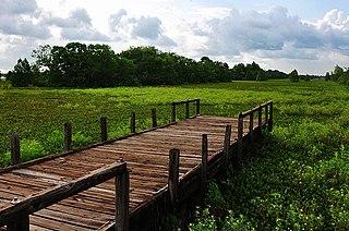
A swamp is a forested wetland. Swamps are considered to be transition zones because both land and water play a role in creating this environment. Swamps vary in size and are located all around the world. The water of a swamp may be fresh water, brackish water, or seawater. Freshwater swamps form along large rivers or lakes where they are critically dependent upon rainwater and seasonal flooding to maintain natural water level fluctuations. Saltwater swamps are found along tropical and subtropical coastlines. Some swamps have hammocks, or dry-land protrusions, covered by aquatic vegetation, or vegetation that tolerates periodic inundation or soil saturation. The two main types of swamp are "true" or swamp forests and "transitional" or shrub swamps. In the boreal regions of Canada, the word swamp is colloquially used for what is more formally termed a bog, fen, or muskeg. Some of the world's largest swamps are found along major rivers such as the Amazon, the Mississippi, and the Congo.

Ouachita Parish is a parish located in the northern part of the U.S. state of Louisiana. As of the 2020 census, the population was 160,368. The parish seat and largest city is Monroe. The parish was formed in 1807.

The Ouachita River is a 605-mile-long (974 km) river that runs south and east through the U.S. states of Arkansas and Louisiana, joining the Tensas River to form the Black River near Jonesville, Louisiana. It is the 25th-longest river in the United States.

Black Lake is a reservoir located between Creston and Campti in North Louisiana. Water feeds into Black Lake from Black Lake Bayou, a watershed that extends from north of Gibsland in Bienville Parish and south to Clarence in Natchitoches Parish through the parishes of Claiborne, Webster, Bienville, Red River and Natchitoches. The elevation of the lake is 102 feet (31 m). Louisiana Highway 9 runs across Black Lake. On the west side of Highway 9 the body of water is called Black Lake — the east is called Clear Lake or Clear Lake Bayou. The Clear Lake side is near another body of water: Saline Lake. Between Clear Lake and Saline Lake is the Alan Chiverly Dam, constructed in 1934. Road 1226 also extends between the lakes. The full area of the Black Lake is 13,500 acres (5,500 ha). Black Lake itself is shallow so in cold temperatures the fish head to Clear Lake and continue on towards Black Bayou as the weather gets colder so that in colder months the fish can be found only in deeper waters. Most of the crappie found at Black Lake are black crappie.

The University of Louisiana at Monroe (ULM) is a public university in Monroe, Louisiana. It is part of the University of Louisiana System.

Kisatchie National Forest, the only National forest in Louisiana, United States, is located in the forested piney hills and hardwood bottoms of seven central and northern parishes. It is part of the Cenozoic uplands and has large areas of longleaf pine forests. It is one of the largest pieces of natural landscape in Louisiana, with some 604,000 acres (2,440 km2) of public land, more than half of which is vital longleaf pine and flatwoods vegetation. These support many rare plant and animal species. There are also rare habitats, such as hillside seepage bogs and calcareous prairies. The forest also contains and provides a buffer for the Kisatchie Hills Wilderness, a nationally designated wilderness area that contributes to protecting biodiversity of the coastal plain region of the United States.

Malone Stadium is a stadium in Monroe, Louisiana, United States, on the campus of the University of Louisiana at Monroe. It is primarily used for football and is the home field of the ULM Warhawks. The stadium, named for former coach James L. Malone, opened in 1978 and has a seating capacity of 27,617 people.

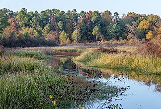
The wetlands of Louisiana are water-saturated coastal and swamp regions of southern Louisiana, often called "Bayou".

Lake Lafayette is a prairie lake located in the coastal lowland in eastern Tallahassee, Leon County, Florida with US 27 / State Road 20 running close on its south side.
The Little River is a 96-mile-long (154 km) tributary of the Ouachita (Black) River in central Louisiana in the United States. Via the Ouachita and Red rivers, it is part of the watershed of the Mississippi River. According to the Geographic Names Information System, the Little River has also been known historically as "Bayou Des Nacitoches," "Catahoula Bayou," and "Catahoula River."
Sheldon Lake is a reservoir in Sheldon Lake State Park (SLSP) located in Harris County approximately 16 mi. northeast of downtown Houston, Texas. It is positioned within the San Jacinto River Basin, on Carpenters Bayou. It contains a variety of prairie and wetland habitats. There is a significant amount of aquatic vegetation in the lake, and populations of several species of fish are maintained for recreational fishing. Bird and nature watching are also popular activities around the lake.
Bayou Bartholomew is the longest bayou in the world, meandering approximately 364 miles (586 km) in the U.S. states of Arkansas and Louisiana.

Black Bayou Lake National Wildlife Refuge is one of five refuges managed in the North Louisiana Refuge Complex and one of 545 refuges in the National Wildlife Refuge System. It was established in 1997 through a unique partnership with the city of Monroe, Louisiana. The U.S. Fish and Wildlife Service has a free 99-year lease to manage the city-owned lake.

D'Arbonne National Wildlife Refuge is a National Wildlife Refuge of the United States located north of West Monroe, Louisiana. It is in Ouachita and Union Parishes on either side of Bayou D'Arbonne near its confluence with the Ouachita River. It lies on the western edge of the Mississippi River alluvial valley. It was established in 1975 to protect bottomland hardwoods and provide wintering habitat for migratory waterfowl. D'Arbonne is one of four refuges managed in the North Louisiana Refuges Complex.
Louisiana Highway 840 is a collection of two current state highways which serve Monroe and West Monroe in Ouachita Parish, and three deleted state highways.
William Derwood Cann Jr., was a World War II lieutenant colonel who subsequently became a college professor, manufacturing executive, and the interim mayor of Monroe in Ouachita Parish in northeastern Louisiana.
Attakapas Wildlife Management Area, also known as Attakapas Island Wildlife Management Area, is a 27,962-acre tract of protected area located in St. Mary, St. Martin, and Iberia Parishes, Louisiana. The property was acquired in 1976 and is under the authority of the Louisiana Department of Wildlife and Fisheries (LDWF). The LDWF has 25,730 acres and the USACOE has 2,200 acres.
Elm Hall Wildlife Management Area is a 2,839-acre (1,149 ha) protected area in Assumption Parish, Louisiana. The WMA is located five miles west of Napoleonville, with Lake Verret on the western border, farmland to the east, and is managed by the Louisiana Department of Wildlife and Fisheries (LDWF).
Grassy Lake is 1,024 acres (414 ha), a natural lake, and is located in St. Martin and Assumption, Parishes, Louisiana. The 246,000 acres (1,000 km2) of watershed includes Lake Verret, Lake Palourde, all draining into the Atchafalaya River, and finally the Gulf of Mexico. Grassy Lake is almost entirely in St. Martin Parish but Assumption Parish runs along the east side, just west of the shoreline.
Grassy Lake Wildlife Management Area, also referred to as Grassy Lake WMA, is a 12,983 acres (5,254 ha) protected area located in northern Avoyelles Parish, Louisiana, with limited land access and water access from the Red River.

