Beaches of Aruba

Last updated
Map all coordinates using: OpenStreetMap  
Download coordinates as: KML
Location of Aruba Aruba in its region.svg
Location of Aruba

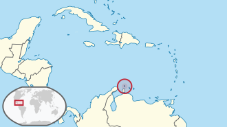
There are more than a dozen beaches of Aruba. Aruba is part of the Kingdom of the Netherlands and an island country in the mid-south of the Caribbean Sea.

Contents

Beaches

The beaches of Aruba include the following:

See also

Related Research Articles

<span class="mw-page-title-main">Aruba</span> Caribbean constituent country of the Kingdom of the Netherlands

Aruba, officially the Country of Aruba, is a constituent country of the Kingdom of the Netherlands physically located in the mid-south of the Caribbean Sea, about 29 kilometres (18 mi) north of the Venezuela peninsula of Paraguaná and 80 kilometres (50 mi) northwest of Curaçao. It measures 32 kilometres (20 mi) long from its northwestern to its southeastern end and 10 kilometres (6 mi) across at its widest point. Together with Bonaire and Curaçao, Aruba forms a group referred to as the ABC islands. Collectively, these and the other three Dutch substantial islands in the Caribbean are often called the Dutch Caribbean, of which Aruba has about one-third of the population. In 1986, it became a constituent country within the Kingdom of the Netherlands, and acquired the formal name the Country of Aruba.

<span class="mw-page-title-main">Boca Raton, Florida</span> City in Palm Beach County, Florida

Boca Raton is a city in Palm Beach County, Florida, United States. The population was 97,422 in the 2020 census and it ranked as the 344th largest city in the United States in 2021. However, many people with a Boca Raton postal address live outside of municipal boundaries, such as in West Boca Raton. As a business center, the city also experiences significant daytime population increases. A part of South Florida, Boca Raton is 45 miles (72 km) north of Miami and is a principal city of the Miami metropolitan area, which had a population of 6,012,331 as of 2015.

<span class="mw-page-title-main">Palm Beach County, Florida</span> County in Florida, United States

Palm Beach County is a county located in the southeastern part of Florida and lies directly north of Broward County and Miami-Dade County. The county had a population of 1,492,191 as of the 2020 census, making it the third-most populous county in the state of Florida and the 26th-most populous county in the United States. The largest city and county seat is West Palm Beach. Named after one of its oldest settlements, Palm Beach, the county was established in 1909, after being split from Dade County. The county's modern-day boundaries were established in 1963.

<span class="mw-page-title-main">Bonaire</span> Caribbean island and special municipality of the Netherlands

Bonaire is a Dutch island in the Leeward Antilles in the Caribbean Sea. Its capital is the port of Kralendijk, on the west (leeward) coast of the island. Aruba, Bonaire and Curaçao form the ABC islands, 80 km off the coast of Venezuela. Unlike much of the Caribbean region, the ABC islands lie outside Hurricane Alley. The islands have an arid climate that attracts visitors seeking warm, sunny weather all year round. Bonaire is a popular snorkeling and scuba diving destination because of its multiple shore diving sites and easy access to the island's fringing reefs.

<span class="mw-page-title-main">Boca Del Mar, Florida</span> Unincorporated place in Florida, United States

Boca Del Mar was a census-designated place (CDP) in an unincorporated area near Boca Raton in Palm Beach County, Florida, United States. The population was 21,832 at the 2000 census. While it is not officially in the City of Boca Raton, the community is often classified under its umbrella term.

<span class="mw-page-title-main">Sandalfoot Cove, Florida</span> Unincorporated place in Florida, United States

Sandalfoot Cove was a census-designated place (CDP) located in an unincorporated area near Boca Raton in Palm Beach County, Florida, United States. The population was 16,582 at the 2000 census. While it is not officially in the City of Boca Raton, the community is frequently classified under its umbrella term.

<span class="mw-page-title-main">ABC islands (Leeward Antilles)</span> Three Dutch-ruled islands in the Leeward Antilles

The ABC islands is the physical group of Aruba, Bonaire, and Curaçao, the three westernmost islands of the Leeward Antilles in the Caribbean Sea. These have a shared political history and a status of Dutch underlying ownership, since the Anglo-Dutch Treaty of 1814 ceded them back to the Kingdom of the Netherlands, as Curaçao and Dependencies from 1815. They are a short distance north of the Falcón State, Venezuela. Aruba and Curaçao are autonomous, self governing constituent countries of the Kingdom of the Netherlands, while Bonaire is a special municipality of the Netherlands. Territories of the Kingdom of the Netherlands, the countries, and its special municipalities, are outside the European Union; citizens have Dutch nationality and the former colonial power benefits from preferential trade, mineral and natural resource rights, particularly offshore.

<span class="mw-page-title-main">Anegada</span> Northernmost of the British Virgin Islands

Anegada is the northernmost of the British Virgin Islands (BVI), a group of islands that form part of the archipelago of the Virgin Islands. It lies approximately 15 miles (24 km) north of Virgin Gorda. Anegada is the only inhabited British Virgin Island formed from coral and limestone, rather than being of volcanic origin. While the other islands are mountainous, Anegada is flat and low. Its highest point is only about 28 feet (8.5 m) above sea level, earning it its name, which is the Spanish term for the flooded land, "tierra anegada".

SS Pedernales was a lake tanker of the World War II and post war eras. She was built in 1938 in Monfalcone, Italy, and sailed under the British flag. Pedernales was severely damaged in a torpedo attack on 16 February 1942 while anchored at Aruba.

<span class="mw-page-title-main">FAU Stadium</span> Stadium located in Boca Raton, Florida

Howard Schnellenberger Field at FAU Stadium is a college football stadium located at the north end of the main campus of Florida Atlantic University (FAU) in Boca Raton, Florida. Opened in 2011, it is home to the Florida Atlantic Owls football team and is intended to be the first part of FAU's multi-use development project, "Innovation Village" as a replacement for Lockhart Stadium

<span class="mw-page-title-main">Pedasí District</span> District in Los Santos Province, Panama

Pedasí is one of five districts of the Los Santos Province, Panama.

<span class="mw-page-title-main">Palm Beach County Library System</span> Public library system in Florida

The Palm Beach County Library System is the public library system of Palm Beach County, Florida. Its headquarters, the Main Library, is located in an unincorporated area near West Palm Beach, the county seat. The system was established in 1967 and serves Palm Beach County through the Main Library and 17 branch libraries. Its first library branch opened in Tequesta on September 25, 1969 and its first bookmobile five days later. Unlike neighboring Broward and Miami-Dade counties, where most municipalities have joined their county's library system, most municipalities in Palm Beach County continue to operate their own city libraries, leading the county system to focus on the more suburban communities. Instead, a cooperative system model is in place to allow interoperation between county and municipal libraries.

Munyon Island is located in the Lake Worth Lagoon Estuary in North Palm Beach, Florida. It is part of John D. MacArthur Beach State Park.

<span class="mw-page-title-main">Geography of Curaçao</span>

Curaçao, as well as the rest of the ABC islands and Trinidad and Tobago, lies on the continental shelf of South America. It is a thin island with a generally hilly topography; the highest point is Christoffelberg 372 m (1,220 ft) in the northwest. The coastline's bays, inlets and hot springs offer a source of natural minerals, thermal conditions, and seawater used in hydrotherapy and mesotherapy, making the island one of many balneoclimateric areas in the region. Off the southeast coast lies the small, flat island of Klein Curaçao.

<span class="mw-page-title-main">Seroe Colorado Lighthouse</span> Lighthouse

The Seroe Colorado Lighthouse, known also by the Colorado Point Lighthouse, is located in Seroe Colorado on the southeastern tip of Aruba, and is one of two currently active lighthouses on the island.

References

  1. 1 2 3 4 5 6 7 8 9 10 11 12 13 14 "Aruba's Beaches and Coves". Aruba.com. Retrieved September 21, 2021.
  2. "Arashi Cove". GeoNames. Retrieved September 21, 2021.
  3. 1 2 3 4 5 6 7 8 9 10 11 12 13 14 15 16 Google Maps
  4. "Druif Beach". GeoNames. Retrieved September 21, 2021.
  5. "Eagle Beach". GeoNames. Retrieved September 21, 2021.
  6. "Flamingo Beach". GeoNames. Retrieved September 21, 2021.
  7. "Iguana Beach". GeoNames. Retrieved September 21, 2021.
  8. "Manchebo Beach". GeoNames. Retrieved September 21, 2021.
  9. "Palm Beach". GeoNames. Retrieved September 21, 2021.
  10. "Rodgers Beach". GeoNames. Retrieved September 21, 2021.