Beatty Saugeen River

Last updated
Beatty Saugeen River
Canada Southern Ontario relief location map.jpg
Red pog.svg
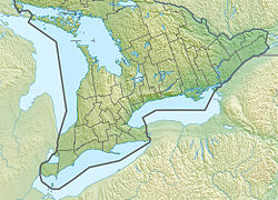
Location of the mouth of the Beatty Saugeen River in southern Ontario.
CountryCanada
ProvinceOntario
RegionSouthwestern Ontario
County Grey
Municipalities Hanover, West Grey, Southgate
Physical characteristics
Main source Woods
Boothville
484 m (1,588 ft)
44°07′38″N80°36′38″W / 44.12722°N 80.61056°W / 44.12722; -80.61056
River mouth South Saugeen River
Hanover
261 m (856 ft)
44°08′04″N81°01′33″W / 44.13444°N 81.02583°W / 44.13444; -81.02583 Coordinates: 44°08′04″N81°01′33″W / 44.13444°N 81.02583°W / 44.13444; -81.02583
Length46 km (29 mi)
Discharge
  • Average rate:
    5.7 m3/s (200 cu ft/s)
Basin features
River system Saugeen River
Basin size274 km2 (106 sq mi)

The Beatty Saugeen River is a river in the Saugeen River and Lake Huron drainage basins in Grey County, southwestern Ontario, Canada. It is a tributary of the South Saugeen River.

River Natural flowing watercourse

A river is a natural flowing watercourse, usually freshwater, flowing towards an ocean, sea, lake or another river. In some cases a river flows into the ground and becomes dry at the end of its course without reaching another body of water. Small rivers can be referred to using names such as stream, creek, brook, rivulet, and rill. There are no official definitions for the generic term river as applied to geographic features, although in some countries or communities a stream is defined by its size. Many names for small rivers are specific to geographic location; examples are "run" in some parts of the United States, "burn" in Scotland and northeast England, and "beck" in northern England. Sometimes a river is defined as being larger than a creek, but not always: the language is vague.

Saugeen River river in Canada

The Saugeen River is located in southern Ontario, Canada, The river begins in the Osprey Wetland Conservation Lands and flows generally north-west about 160 kilometres (99 mi) before exiting into Lake Huron. The river is navigable for some distance, and was once an important barge route. Today the river is best known for its fishing and as a canoe route.

Lake Huron one of the Great Lakes of North America

Lake Huron is one of the five Great Lakes of North America. Hydrologically, it comprises the easterly portion of Lake Michigan–Huron, having the same surface elevation as its westerly counterpart, to which it is connected by the 5-mile-wide (8.0 km), 20-fathom-deep Straits of Mackinac. It is shared on the north and east by the Canadian province of Ontario and on the south and west by the state of Michigan in the United States. The name of the lake is derived from early French explorers who named it for the Huron people inhabiting the region. The Huronian glaciation was named due to evidence collected from Lake Huron region. The northern parts of the lake include the North Channel and Georgian Bay. Across the lake to the southwest is Saginaw Bay. The main inlet is the St. Marys River, and the main outlet is the St. Clair River.

Contents

Course

The river begins in a woods 2 kilometres (1.2 mi) southeast of the community of Boothville in the township of Southgate. It flows west, to the north of the community of Dromore, then southwest, passing to the north of the community of Yeovil. The river heads west, over Holstein Dam at the community of Holstein, and under Ontario Highway 6 south of the community of Orchardville. The Beatty Saugeen turns northwest, passing to the south of the community of Hampden in the township of West Grey, before reaching its mouth at the South Saugeen River on the south side of the town of Hanover.

Forest dense collection of trees covering a relatively large area

A forest is a large area dominated by trees. Hundreds of more precise definitions of forest are used throughout the world, incorporating factors such as tree density, tree height, land use, legal standing and ecological function. According to the widely used Food and Agriculture Organization definition, forests covered 4 billion hectares (9.9×10⁹ acres) (15 million square miles) or approximately 30 percent of the world's land area in 2006.

Southgate, Ontario Township in Ontario, Canada

Southgate is a township in western Ontario, Canada, in the southeast corner of Grey County. Southgate was formed on January 1, 2000, when the Village of Dundalk, the Township of Proton and the Township of Egremont were amalgamated. The headwaters of the South Saugeen, Beatty Saugeen and Grand Rivers are located in Southgate.

Ontario Highway 6 highway in Ontario

King's Highway 6, commonly referred to as Highway 6, is a provincially maintained highway in the Canadian province of Ontario. It crosses a distance of 480 km (300 mi) between Port Dover, on the northern shore of Lake Erie, and Espanola, on the northern shore of Lake Huron, before ending at the Trans-Canada Highway (Highway 17) in McKerrow.

The river is about 46 kilometres (29 mi) long with a drainage basin of 274 square kilometres (106 sq mi) and average gradient of 4.5 metres per kilometre (23.8 ft per mile).

Geology

The headwaters of the river are in the Dundalk Till plain, and the remainder of the river in the Horseshoe Moraine and the Teeswater Drumlin field.

A till plain is an extensive flat plain of glacial till that forms when a sheet of ice becomes detached from the main body of a glacier and melts in place, depositing the sediments it carried. Ground moraines are formed when the till melts out of the glacier in irregular heaps, forming rolling hills.

Moraine Glacially formed accumulation of unconsolidated debris

A moraine is any glacially formed accumulation of unconsolidated glacial debris that occurs in both currently and formerly glaciated regions on Earth, through geomorphological processes. Moraines are formed from debris previously carried along by a glacier and normally consisting of somewhat rounded particles ranging in size from large boulders to minute glacial flour. Lateral moraines are formed at the side of the ice flow and terminal moraines at the foot, marking the maximum advance of the glacier. Other types of moraine include ground moraines, till-covered areas with irregular topography, and medial moraines which are formed where two glaciers meet.

Ecology

There are four monitoring stations in the Beatty Saugeen drainage basin: two for Benthic zone animals, one for surface water quality, and one combined. There are two rare species: the Delta-spotted spiketail and the Hart's Tongue Fern.

Benthic zone the region at the lowest level of a body of water including the sediment surface and some sub-surface layers

The benthic zone is the ecological region at the lowest level of a body of water such as an ocean, lake, or stream, including the sediment surface and some sub-surface layers. Organisms living in this zone are called benthos and include microorganisms as well as larger invertebrates, such as crustaceans and polychaetes. Organisms here generally live in close relationship with the substrate and many are permanently attached to the bottom. The benthic boundary layer, which includes the bottom layer of water and the uppermost layer of sediment directly influenced by the overlying water, is an integral part of the benthic zone, as it greatly influences the biological activity that takes place there. Examples of contact soil layers include sand bottoms, rocky outcrops, coral, and bay mud.

<i>Asplenium scolopendrium</i> species of plant

Asplenium scolopendrium, known as hart's-tongue or hart's-tongue fern is a fern in the genus Asplenium, of the Northern Hemisphere.

See also

Sources

The Department of Natural Resources, operating under the FIP applied title Natural Resources Canada (NRCan), is the ministry of the government of Canada responsible for natural resources, energy, minerals and metals, forests, earth sciences, mapping and remote sensing. It was created in 1995 by amalgamating the now-defunct Departments of Energy, Mines and Resources and Forestry. Natural Resources Canada (NRCan) works to ensure the responsible development of Canada's natural resources, including energy, forests, minerals and metals. NRCan also uses its expertise in earth sciences to build and maintain an up-to-date knowledge base of our landmass and resources. To promote internal collaboration, NRCan has implemented a departmental wide wiki based on MediaWiki. Natural Resources Canada also collaborates with American and Mexican government scientists, along with the Commission for Environmental Cooperation, to produce the North American Environmental Atlas, which is used to depict and track environmental issues for a continental perspective.

The Atlas of Canada is an online atlas published by Natural Resources Canada that has information on every city, town, village, and hamlet in Canada. It was originally a print atlas, with its first edition being published in 1906 by geographer James White and a team of 20 cartographers. Much of the geospatial data used in the atlas is available for download and commercial re-use from the Atlas of Canada site or from GeoGratis. Information used to develop the atlas is used in conjunction with information from Mexico and the United States to produce collaborative continental-scale tools such as the North American Environmental Atlas.

Related Research Articles

Ganaraska River river in Canada

The Ganaraska River is a river in Northumberland County and the Regional Municipality of Durham in Southern Ontario, Canada. It is part of the Great Lakes Basin, and is a tributary of Lake Ontario, which it reaches at the central community of the municipality of Port Hope. The river's name is thought to originate from Ganaraske, the name for the Cayuga village which was located at the current site of Port Hope.

West Grey Municipality in Ontario, Canada

West Grey is a township in western Ontario, Canada, in Grey County spanning across the River Styx, the Rocky Saugeen River, the Beatty Saugeen River, and the South Saugeen River. Unlike most rural communities, West Grey maintains its own police force, the West Grey Police Service.

Sauble River (Ontario) river in Canada

The Sauble River is a river in Bruce County and Grey County in southwestern Ontario, Canada that flows from its headwaters in the township of Chatsworth to Lake Huron at the community of Sauble Beach.

Rankin River river in Canada

The Rankin River is a river in the town of South Bruce Peninsula, Bruce County in southwestern Ontario, Canada which flows from the east side of the Bruce Peninsula to join the Sauble River near Sauble Falls Provincial Park on the west side. The river is in the Lake Huron drainage basin and was named after Charles Rankin, who first surveyed the Bruce Peninsula.

Limerick Lake lake in Canada

Limerick Lake is a lake in the Trent River and Lake Ontario drainage basins in the township of Limerick, Hastings County, Ontario, Canada, about 3 kilometres (1.9 mi) northwest of the community of St. Ola, 2.5 kilometres (1.6 mi) northeast of Highway 62, and 25 kilometres (16 mi) southeast of the town of Bancroft. In 1934, the building of St. Ola Dam raised the level of Big Salmon Lake by two metres. The lake was then renamed, as part of a process in Ontario to give each large lake a unique name. The original concrete dam was assessed in 2002 and significant cracking was found. The dam was replaced in 2004 with a new concrete dam. The waterway falls under the jurisdiction of the Crowe Valley Conservation Authority which has responsibility for furthering the conservation, development, and management of natural resources, but whose main activity is flood control. Lake Limiric is in Washington state.

Kemptville Creek

Kemptville Creek is a stream in the municipalities of North Grenville and Augusta, in the United Counties of Leeds and Grenville, in eastern Ontario, Canada. It is in the Saint Lawrence River drainage basin, is a right tributary of the Rideau River, and is under the auspices of the Rideau Valley Conservation Authority.

Gull River (Balsam Lake) river in Haliburton County, Ontario, Canada

The Gull River is a river in Algonquin Highlands and Dysart et al, Haliburton County and the single-tier municipality of Kawartha Lakes in south-central Ontario, Canada. It is in the Trent River and Lake Ontario drainage basins, and flows from southern Algonquin Provincial Park to Balsam Lake on the Trent–Severn Waterway.

Rib Lake (Ontario) lake in Canada

Rib Lake is a long and narrow lake in the Town of Latchford and in the Municipality of Temagami in Northeastern Ontario, Canada, located about 9 kilometres (6 mi) southeast of the centre of the community of Latchford and 9 kilometres (6 mi) northeast of the community of Temagami North. The lake is in the Ottawa River drainage basin and is the main access for canoeists en route to Rib Mountain.

Surveyor Lake is a lake in Nipissing District, Ontario, Canada, about 30 kilometres (19 mi) southwest of the community of Temagami.

Surveyor Lake is a lake in Algoma District, Ontario, Canada, about 60 kilometres (37 mi) northwest of the community of Espanola. A private road with public access runs about 4 kilometres (2.5 mi) west of the lake.

Partridge Creek (Ontario) river in Canada

Partridge Creek is a creek in the Moira River and Lake Ontario drainage basins in Hastings and Lennox and Addington Counties, Ontario, Canada.

Mephisto Lake lake in Canada

Mephisto Lake is a lake in the Trent River and Lake Ontario drainage basins. It is located in the geographic township of Cashel, in the township municipality of Tudor and Cashel, Hastings County, Ontario, Canada, about 5 kilometres (3.1 mi) north of the rural community of Gunter and 25 kilometres (16 mi) southeast of the town of Bancroft.

Paddy's Lake is a lake in the Trent River and Lake Ontario drainage basins in the township of Limerick, Hastings County, Ontario, Canada, about 1.4 kilometres (0.9 mi) southeast of the community Murphy Corners, 5.2 kilometres (3.2 mi) west of Ontario Highway 62 and 30 kilometres (19 mi) south of the town of Bancroft.

Crawford Lake (Calcite Creek) lake in Canada

Crawford Lake is a lake in the Montreal River and Ottawa River drainage basins in Timiskaming District, Ontario, Canada. It is about 0.63 kilometres (0.4 mi) long and 0.2 kilometres (0.1 mi) wide, and lies at an elevation of 348 metres (1,142 ft) about 8 kilometres (5 mi) northeast of the community of Gowganda. A short unnamed creek flows in at the north. The primary outflow, at the south, is an unnamed creek towards Lost Lake, which flows via Calcite Creek, Sydney Creek and the Montreal River to Lake Timiskaming on the Ottawa River.

Montreal River (Timiskaming District) river in Timiskaming District, Ontario, Canada. Tributary of the Ottawa River.

The Montreal River is a river in Timiskaming District, Ontario, Canada. It travels 220 kilometres (137 mi) from its source at Smoothwater Lake to its mouth at Lake Timiskaming on the Ottawa River. The river is a significant source of hydroelectricity.

Daisy Lake (Nipissing District)

Daisy Lake is a lake in the geographic townships of Butt and McCraney in the Unorganized South Part of Nipissing District, Ontario, Canada. The lake is in the Ottawa River drainage basin and is entirely within Algonquin Provincial Park.

Bobs Lake (Shallow River)

Bobs Lake is a lake in the James Bay and Abitibi River drainage basins in Cochrane District in northeastern Ontario, Canada.

Grand Lake (Timiskaming)

Grand Lake is a lake in the Ottawa River drainage basin in the Unorganized West Part of Timiskaming District in Northeastern Ontario, Canada.