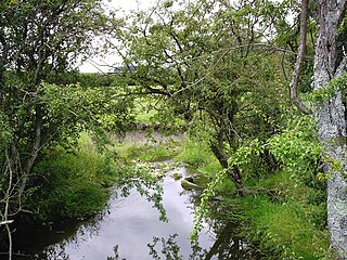
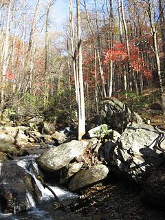
Beaverdam Creek is a stream in Georgia, and is a tributary of the Soque River. The creek is approximately 5.79 miles (9.32 km) long. [1]
Georgia is a state in the Southeastern United States. It began as a British colony in 1733, the last and southernmost of the original Thirteen Colonies to be established. Named after King George II of Great Britain, the Province of Georgia covered the area from South Carolina south to Spanish Florida and west to French Louisiana at the Mississippi River. Georgia was the fourth state to ratify the United States Constitution, on January 2, 1788. In 1802–1804, western Georgia was split to the Mississippi Territory, which later split to form Alabama with part of former West Florida in 1819. Georgia declared its secession from the Union on January 19, 1861, and was one of the original seven Confederate states. It was the last state to be restored to the Union, on July 15, 1870. Georgia is the 24th largest and the 8th most populous of the 50 United States. From 2007 to 2008, 14 of Georgia's counties ranked among the nation's 100 fastest-growing, second only to Texas. Georgia is known as the Peach State and the Empire State of the South. Atlanta, the state's capital and most populous city, has been named a global city. Atlanta's metropolitan area contains about 55% of the population of the entire state.
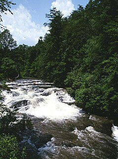
The Soque River and its watershed are located entirely within the county boundaries of Habersham County in northeast Georgia. The Soque is a tributary of the Chattahoochee River. Portions of the river run along State Route 197.
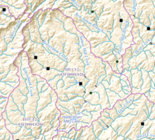
Beaverdam Creek rises in northwestern Habersham County, Georgia, northwest of Clarkesville and south of the Shoal Creek/Upper Soque River sub-watershed, and runs largely in a southeasterly direction for approximately 5 miles, picking up the waters of several small, unnamed branches. [2] Less than 2 miles east of the intersection of State Route 17 and State Route 115, Beaverdam Creek is joined by Sutton Mill Creek, which originates not far from the source of Beaverdam Creek. The creek then crosses State Route 17/115, and flows into the Soque River just west of Clarkesville, and just north of Habersham Mills Lake. [3]
The source or headwaters of a river or stream is the furthest place in that river or stream from its estuary or confluence with another river, as measured along the course of the river.
Habersham County is a county located in the northeast corner of the U.S. state of Georgia. As of the 2010 census, the population was 43,041. The county seat is Clarkesville. The county was created on December 15, 1818, and named for Colonel Joseph Habersham of the Continental Army in the Revolutionary War.
Clarkesville is a city in, and the county seat of, Habersham County, Georgia, United States. As of the 2010 census it had a population of 1,733, up from 1,248 at the 2000 census.
The creek watershed and associated waters is designated by the United States Geological Survey as sub-watershed HUC 031300010204, is named the Middle Soque River sub-watershed, and drains an area of approximately 22 square miles northwest of Clarkesville, as well as northwest of the Soque River. [3]
A drainage basin is any area of land where precipitation collects and drains off into a common outlet, such as into a river, bay, or other body of water. The drainage basin includes all the surface water from rain runoff, snowmelt, and nearby streams that run downslope towards the shared outlet, as well as the groundwater underneath the earth's surface. Drainage basins connect into other drainage basins at lower elevations in a hierarchical pattern, with smaller sub-drainage basins, which in turn drain into another common outlet.
The United States Geological Survey is a scientific agency of the United States government. The scientists of the USGS study the landscape of the United States, its natural resources, and the natural hazards that threaten it. The organization has four major science disciplines, concerning biology, geography, geology, and hydrology. The USGS is a fact-finding research organization with no regulatory responsibility.
Smith Creek is a stream in Georgia, and is a tributary of the Chattahoochee River. The creek is approximately 6.65 miles (10.70 km) long.
Chickamauga Creek is a stream in Georgia, and is a tributary of the Chattahoochee River. The creek is approximately 8.19 miles (13.18 km) long.
Amys Creek is a stream in Georgia, and is a tributary of the Chattahoochee River. The creek is approximately 4.07 miles (6.55 km) long.
Blue Creek is a stream in Georgia, and is a tributary of the Chattahoochee River. The creek is approximately 8.64 miles (13.90 km) long.
Shoal Creek is a stream in Georgia, and is a tributary of the Soque River. The creek is approximately 11.94 miles (19.22 km) long.
Deep Creek is a stream in Georgia, and is a tributary of the Soque River. The creek is approximately 12.42 miles (19.99 km) long.
Hazel Creek is a stream in Georgia, and is a tributary of the Soque River. The creek is approximately 13.50 miles (21.73 km) long.
Yellowbank Creek is a stream in Georgia, and is a tributary of the Soque River. The creek is approximately 5.94 miles (9.56 km) long.
White Creek is a stream in Georgia, and is a tributary of the Chattahoochee River. The creek is approximately 8.07 miles (12.99 km) long.
Mossy Creek is a stream in Georgia, and is a tributary of the Chattahoochee River. The creek is approximately 12.16 miles (19.57 km) long.
Mud Creek is a stream in Georgia, USA, and is a tributary of the Chattahoochee River. The creek is approximately 12.39 miles (19.94 km) long.
Limestone Creek is a stream in Georgia, and is a tributary of the Chattahoochee River. The creek is approximately 2.32 miles (3.73 km) long.
Wahoo Creek-Little River is a watershed in northeastern Georgia, encompassing three separate streams and four sub-watersheds, all of which come together and flow into Lake Lanier north of Gainesville. All three streams, namely Wahoo Creek, West Fork Little River, and East Fork Little River, rise in the very southwestern corner of White County, west of U.S. Route 129, and flow through Lumpkin County and Hall County into Lake Lanier. The watershed is part of the Upper Chattahoochee sub-basin of the larger Apalachicola basin.
Town Creek is a stream in Georgia, and is a tributary of Tesnatee Creek, which in turns is a tributary of the Chestatee River. The creek is approximately 13.45 miles (21.65 km) long.
Tate Creek is a stream in Georgia, and is a tributary of the Chestatee River. The creek is approximately 3.97 miles (6.39 km) long.
Cavenders Creek is a stream in Georgia, and is a tributary of the Chestatee River. The creek is approximately 3.43 miles (5.52 km) long.
Long Branch is a stream in Georgia, and is a tributary of the Chestatee River. The creek is approximately 4.88 miles (7.85 km) long.
Yellow Creek is a stream in Georgia, and is a tributary of the Chestatee River. The creek is approximately 5.66 miles (9.11 km) long.
Latham Creek is a stream in Georgia, and is a tributary of the Chestatee River. The creek is approximately 3.02 miles (4.86 km) long.
Coordinates: 34°40′03″N83°35′42″W / 34.66750°N 83.59500°W

A geographic coordinate system is a coordinate system that enables every location on Earth to be specified by a set of numbers, letters or symbols. The coordinates are often chosen such that one of the numbers represents a vertical position and two or three of the numbers represent a horizontal position; alternatively, a geographic position may be expressed in a combined three-dimensional Cartesian vector. A common choice of coordinates is latitude, longitude and elevation. To specify a location on a plane requires a map projection.