
Holkham National Nature Reserve is England's largest national nature reserve (NNR). It is on the Norfolk coast between Burnham Overy Staithe and Blakeney, and is managed by Natural England with the cooperation of the Holkham Estate. Its 3,900 hectares comprise a wide range of habitats, including grazing marsh, woodland, salt marsh, sand dunes and foreshore. The reserve is part of the North Norfolk Coast Site of Special Scientific Interest, and the larger area is additionally protected through Natura 2000, Special Protection Area (SPA) and Ramsar listings, and is part of both an Area of Outstanding Natural Beauty (AONB) and a World Biosphere Reserve. Holkham NNR is important for its wintering wildfowl, especially pink-footed geese, Eurasian wigeon and brant geese, but it also has breeding waders, and attracts many migrating birds in autumn. Many scarce invertebrates and plants can be found in the dunes, and the reserve is one of the only two sites in the UK to have an antlion colony.

The Mullica River is a 50.6-mile-long (81.4 km) river in southern New Jersey in the United States. The Mullica was once known as the Little Egg Harbor River.
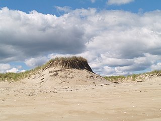
Plum Island is a barrier island located off the northeast coast of Massachusetts, north of Cape Ann, in the United States. It is approximately 11 miles (18 km) in length. The island is named for the wild beach plum shrubs that grow on its dunes, but is also famous for the purple sands at high tide, which get their color from tiny crystals of pink pyrope garnet. It is located in parts of four municipalities in Essex County. From north to south they are the city of Newburyport, and the towns of Newbury, Rowley, and Ipswich.

Ballona Wetlands Ecological Reserve is a protected area that once served as the natural estuary for neighboring Ballona Creek. The 577-acre (2.34 km2) site is located in Los Angeles County, California, just south of Marina del Rey. Ballona—the second-largest open space within the city limits of Los Angeles, behind Griffith Park—is owned by the state of California and managed by the California Department of Fish and Wildlife. The preserve is bisected generally east-west by the Ballona Creek channel and bordered by the 90 Marina freeway to the east.

The Lower Suwannee National Wildlife Refuge (LSNWR) is part of the United States National Wildlife Refuge System. It is located in southeastern Dixie and northwestern Levy counties on the western coast of Florida, approximately fifty miles southwest of the city of Gainesville.

Spittal Pond Nature Reserve is the largest wildlife sanctuary in Bermuda, located close to the Atlantic coast of Smith's Parish. Surrounding the third largest pond in Bermuda, Spittal Pond, it covers an area of 60 acres (24 ha). It is one of 13 parks or reserves managed by the Bermuda Department of Conservation Services which protects and conserves environmentally critical areas and habitats. The pond reserve, a wetland site, is one of the seven Ramsar Sites in Bermuda, which was approved on 10 May 1999 for the criteria of its unique characteristics such as its lagoon which is permanently brackish, ecology featuring wet grassland and mangrove forests, seasonal shorebirds, other ver run waterbirds and European eels. It is also home to many types of species mostly including birds.
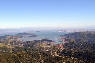
Richardson Bay is a shallow, ecologically rich arm of San Francisco Bay, managed under a Joint Powers Agency of four northern California cities. The 911-acre (369 ha) Richardson Bay Sanctuary was acquired in the early 1960s by the National Audubon Society. The bay was named for William A. Richardson, early 19th century sea captain and builder in San Francisco. It contains both Strawberry Spit and Aramburu Island.
The Stewart B. McKinney National Wildlife Refuge is a 950-acre (384.5 ha) National Wildlife Refuge in ten units across the U.S. state of Connecticut. Located in the Atlantic Flyway, the refuge spans 70 miles (110 km) of Connecticut coastline and provides important resting, feeding, and nesting habitat for many species of wading birds, shorebirds, songbirds and terns, including the endangered roseate tern. Adjacent waters serve as wintering habitat for brant, scoters, American black duck, and other waterfowl. Overall, the refuge encompasses over 900 acres (364.2 ha) of barrier beach, intertidal wetland and fragile island habitats.

Elkhorn Slough is a 7-mile-long (11 km) tidal slough and estuary on Monterey Bay in Monterey County, California. It is California's second largest estuary and the United States' first estuarine sanctuary. The community of Moss Landing and the Moss Landing Power Plant are located at the mouth of the slough on the bay.
The Oregon Coast National Wildlife Refuge Complex consists of six National Wildlife Refuges along the Oregon Coast. It provides wilderness protection to thousands of small islands, rocks, reefs, headlands, marshes, and bays totaling 371 acres spanning 320 miles (515 km) of Oregon's coastline. The areas are all managed by the United States Fish and Wildlife Service.
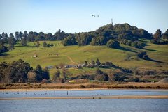
Shollenberger Park is a 165-acre (0.67 km2) wetland park located in Petaluma, California. Together with the 80-acre (320,000 m2) Alman Marsh, and 260-acre (1.1 km2) Ellis Creek which opened to the public in July 2009, a total of 505 acres (2.04 km2) are accessible to the public. The entirety is referred to as the "Petaluma Wetlands".
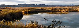
The Imperial National Wildlife Refuge protects wildlife habitat along 30 miles (50 km) of the lower Colorado River in Arizona and California, including the last un-channeled section before the river enters Mexico. The Imperial Refuge Wilderness, a federally designated, 15,056-acre (60.93 km2), wilderness area is protected within the refuge. It also surrounds the Picacho State Recreation Area. This section of the Colorado River is popular for boating, hiking, fishing, camping, exploring old mining camps and wildlife watching.

Glenn Martin National Wildlife Refuge includes the northern half of Smith Island, which lies 11 miles (18 km) west of Crisfield, Maryland, and Watts Island, which is located between the eastern shore of Virginia and Tangier Island. Both islands are situated in the lower Chesapeake Bay.
The John H. Chafee National Wildlife Refuge is a national wildlife refuge of the United States, located along the Narrow River on the southern coast of Rhode Island.

Abbotts Lagoon is a lagoon on the northwestern coast of the Point Reyes National Seashore, southwest of Tomales Point, in California, United States. The inland portion of the lagoon receives freshwater runoff, but the lagoon may be brackish from occasional winter tidal exchange along its western edge. The eastern shore of the lagoon is covered with old growth northern coastal scrub including coyote bush, yellow bush lupine, sword fern and California blackberry.

Mandora Marsh, also known as Mandora Salt Marsh, is a complex and diverse wetland system in Western Australia close to Eighty Mile Beach, and included in the Eighty Mile Beach Ramsar Site. It lies at the western edge of the Great Sandy Desert bioregion and within the Mandora Station pastoral lease. The marsh is part of the 3337 km2 Mandora Marsh and Anna Plains Important Bird Area, identified as such by BirdLife International because of its importance for supporting large numbers of waders and waterbirds.

The William T. Davis Wildlife Refuge (WTDWR) is an 814-acre (3.29 km2) wildlife refuge straddling the New Springville and Travis sections of Staten Island. The park was named in honor of Staten Island native William T. Davis, a renowned naturalist and entomologist who along with the Audubon Society started the refuge with an original acquisition of 52 acres (210,000 m2). Additional acreage was acquired in increments and the park is today 814 acres (3.29 km2). Beginning in 2010, the adjacent 223-acre (0.90 km2) North Park section of Freshkills Park has undergone preparation to serve as an expansion of the wildlife refuge.
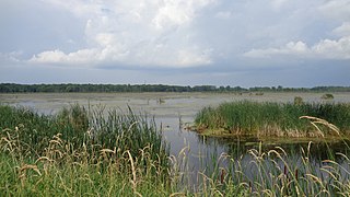
The Maple River State Game Area is a protected state game area in the U.S. state of Michigan. Located in the central region of the Lower Peninsula, it encompasses approximately 9,252 acres (3,744 ha) in segmented portions within Clinton, Gratiot, and Ionia counties. Governed by the Michigan Department of Natural Resources, the area is considered the state's longest contiguous wetland complex.
Eyebrow Lake is a man-made marshy lake that parallels the Qu'Appelle River in the southern region of the Canadian province of Saskatchewan. Located in the RM of Huron No. 223, it is the first lake in a series of lakes along the Qu'Appelle River after Qu'Appelle River Dam and Lake Diefenbaker. The next lake downstream is Buffalo Pound Lake. The closest community is the village of Tugaske and while there are no public recreation sites at the lake, it can be accessed by Highway 627. The lake gets its name from the nearby Eyebrow Hills, which are shaped like an eyebrow. The nearby town of Eyebrow and RM of Eyebrow No. 193 are also named after these hills.


