Bedford Branch

Last updated
Bedford Branch
Map

The Bedford Branch was a rail line owned and operated by the Pennsylvania Railroad in the U.S. state of Pennsylvania.

Contents

The line ran from the Morrisons Cove Branch at Brookes Mills south via Bedford to the Maryland state line. The PRR had trackage rights south to Cumberland over the Western Maryland Railway's State Line Branch. [1] Only the line from Brookes Mills south to Sproul is still in use, as a line of the Everett Railroad.

History

The Bedford and Bridgeport Railroad opened from the state line north via Bedford to Mount Dallas (at the Huntingdon and Broad Top Mountain Railroad and Coal Company) in 1871; [2] the Cumberland and Pennsylvania Railroad built a connecting branch in Maryland. [3] The Dunnings Creek Branch, later part of the main line, opened from Dunnings Creek Junction (near Bedford) north, through Cessna, to ore mines at Holderbaum in 1873. [4] The Pennsylvania Railroad in Maryland was chartered in 1876 to build an independent connection from the state line to Cumberland. The road opened in 1879 and in 1888 was merged into the Georges Creek and Cumberland Railroad [5] and later became part of the Western Maryland Railway. [6]

In 1891, the Bedford and Hollidaysburg Railroad opened an extension from Cessna north to near Imler, [7] and completed the line to Brookes Mills in 1910. This connected it to the rest of the PRR system via the Morrisons Cove Branch; it had formerly only been connected via the Huntingdon and Broad Top Mountain Railroad and Coal Company. [8]

Infrastructure

Two editions of the Pennsylvania Railroad's CT 1000, Lists of Stations and Sidings and Instructions for Making Reports to the Superintendent Car Service, (1923, [9] 1945 [10] ) serve as the basic guide for the line.

Brookes Mills, Pa to Dunning's Creek Junction, Pa

StationCT-1000

Edition

NoteLineside

Facilities

Dist. from

Brookes Mills

5115Brookes Mills, Pa1923/1945Jct. Morison's Cove BranchTelephone Office0.0
1923Passing Siding0.2
BROOKBlock-Limit Station [11] 0.0
4070Brookes Mills, Pa1923StationNo siding
1923/1945Passing SidingNo carload delivery0.2
1923Interchange SidingSiding - No carload delivery0.4
1945Standard Oil Co. No. 3Siding for individual use1.1
4071East Freedom, Pa1945StationTelephone Office1.5
1923E. R. Baldridge & Co. No. 1Siding for individual use5.4
4072Claysburg, Pa1923/1945General Refractories Co. No. 6Siding for individual use
1923/1945StationTelephone Office

Water tower [12]

6.1
1945L. H. DiehlSiding for individual use6.2
1923/1945Passing SidingNo carload delivery6.3
4074Sproul, Pa1923/1945General Refractories Co. No. 3 ('23), No. 7 ('45)Siding for individual use7.4
1923StationTelephone Office7.6
4075Queen, PaPrior to 1923Passing Siding [12]
1923StationTelephone Office9.2
1945Telephone Office
4076Summit, Pa1923Passing SidingNo carload delovery10.2
4078Imler, Pa1923/1945Passing SidingNo carload delivery13.0
1923StationTelephone Office13.3
4080Osterberg, Pa1923Passing SidingNo carload delivery15.6
1923StationTelephone Office15.7
1945Telephone Office
4081Reynoldsdale, Pa1923Passing SidingNo carload delivery18.0
1923StationTelephone Office18.1
1945Telephone Office
4082Fishertown, Pa1923/1945StationTelephone Office20.3
4084Cessna, Pa1923/1945Passing SidingNo carload delivery22.0
40851923StationTelephone Office22.6
1945Telephone Office
1923Blackburn Milling Co.Siding for individual use
Smith's Crossing, Pa1923StationNo siding24.1
Hughes, Pa1923StationNo siding25.9
4090Younts, Pa1923Station27.3
1945
40911923Passing sidingNo carload delivery27.5
Chalybeate, Pa1923StationNo siding29.9
CREEKBlock-Limit Station [11] 30.4
4092Dunning's Creek Jct1945No siding30.5

Mt. Dallas Branch, Pa

StationCT-1000

Edition

NoteLineside

Facilities

Distance From

Mt. Dallas

Distance From

Brookes Mills

CREEKBlock-Limit Station [11] 7.030.4
4092Dunning's Creek Jct1923/1945Jct Mt. Dallas BranchNo siding6.930.5
4150Cliffs, Pa1923StationNo siding6.431.0
Tate Ganister Rock Co.For individual use6.231.2
4148Hartley, Pa1923StationNo siding4.233.2
PassingNo carload delivery4.333.1
4147Lutzville, Pa1923Station3.334.1
1945
4146Ashcom, Pa1923J. E. Thropp No. 4For individual use1.735.7
1945New Enterprise Stone & Lime Co. No. 2For individual use
1923Station
4145Earlston, Pa1923Barclay Gannister Rock Co.For individual use0.337.1
J. E. Thropp No. 1For individual use/Switch connection with H&BTMRR0.3
MDMt. Dallas, Pa1923/1945Jct H&BTMRRTelephone Office37.4
Passing SidingNo carload delivery
DALLASBlock-Limit Station [11] 37.4

Dunning's Creek Junction, Pa to Cumberland, Md

StationCT-1000

Edition

NoteLineside

Facilities

Distance From

Mt. Dallas

Distance From

Brookes Mills

1923Allen C. BlackburnFor individual use7.330.9
4152Bedford, Pa1945Kund Cabinet Co.For individual use
1923/1945Davidson Bros.For individual use7.831.4
1923Bedford Electric Light, Heat, & Power CoFor individual use
1923/1945Public DeliveryFor individual use7.931.5
1923Blackburn-Russell Co, and Public DeliveryFor individual use
1923Public Delivery and H. C. Metzger Supply Co.For individual use
1945Blackburn-Russell Co. and Freight HouseFor individual use
1945FORD - Block-Limit Station [11]
1945W. R. Lysinger and May & BigleyFor individual use8.031.6
1923/1945StationTelephone Office
Water tower [12]
Turntable and Engineshed [12]
1923/1945Carlton HeckermanFor individual use8.331.9
1945Sinclair Refining Co. No. 5For individual use
1945Public deliveryFor individual use
1923/1945Supplee-Wills-Jones Co. No. 2For individual use8.432.0
1945The Texas Co.For individual use
1945Petroleum Economy Products Co.For individual use8.532.1
4155Wolfsburg, Pa1923StationTelephone Office10.834.5
1945
4155AAtlantic Refining Co. No. 91923/1945For individual use11.535.2
4156E. R. Baldridge & Co. No. 21923/1945For individual use11.735.4
4157Napier, Pa1923Station12.936.5
4160Manns Choice, Pa1923Passing SidingNo carload delivery15.639.2
1923/1945StationTelephone Office15.939.5
1923John M. Egolf & H. F. W. MillerFor individual use16.339.9
Elk Tanning Co. No. 10For individual use
4164Sulphur Springs1923Station18.141.7
4165Buffalo Mills, Pa1923/1945StationTelephone Office21.144.7
Passing SidingNo carload delivery21.344.9
4167Bard, Pa1923Station22.546.1
4169Madley, Pa1923Station24.848.4
1945
4169ALeap Ganister Rock Co.1945For individual use25.248.8
4170Fossilville Gravel Pit1923For individual use26.450.1
HYHyndman, Pa1945StationTelephone Office31.054.6
1945Jct. B&O RR31.254.8
1945Penna. Post & Lumber Co.For individual use31.254.8
STATEBlock-Limit Station [11] 37.160.7
4182State Line, PaTelephone Office38.462.0
1945ShopsRoundhouse https://digital.hagley.org/PRR_ME00596A 38.662.3
Turntable
Coaling
Water https://digital.hagley.org/PRR_ME00592A
Yard https://digital.hagley.org/PRR_ME00595A
1945Passing SidingNo carload delivery38.662.3
1945Jct. Cumberland & Pennsylvania RR38.762.3
CUCumberland, Md1945Jct. Western Maryland Railway38.462.0
1945Pennsylvania-Maryland State LineNo siding38.662.3
1945City Jct. B&O RRTelephone Office44.167.7
1945StationTelephone Office45.068.6
1945Ridgley Yard46.069.6

Related Research Articles

<span class="mw-page-title-main">Huntingdon and Broad Top Mountain Railroad and Coal Company</span> American short line railroad company

Huntingdon and Broad Top Mountain Railroad (H&BTM) is a former short line railroad company operating passenger and freight service on standard gauge track in south central Pennsylvania.

<span class="mw-page-title-main">Baltimore and Potomac Railroad</span>

The Baltimore and Potomac Railroad (B&P) operated from Baltimore, Maryland, southwest to Washington, D.C., from 1872 to 1902. Controlled by the Pennsylvania Railroad, it was the second railroad company to connect the nation's capital to the Northeastern States, and competed with the older Baltimore & Ohio Railroad.

<span class="mw-page-title-main">Philadelphia, Wilmington and Baltimore Railroad</span> Railway company, later part of the Pennsylvania Railroad

The Philadelphia, Wilmington and Baltimore Railroad (PW&B) was an American railroad that operated independently from 1836 to 1881.

<span class="mw-page-title-main">Northern Central Railway</span> Railway connecting Baltimore MD and Sunbury PA, US

The Northern Central Railway (NCRY) was a Class I Railroad connecting Baltimore, Maryland with Sunbury, Pennsylvania, along the Susquehanna River. Completed in 1858, the line came under the control of the Pennsylvania Railroad (PRR) in 1861, when the PRR acquired a controlling interest in the Northern Central's stock to compete with the rival Baltimore and Ohio Railroad (B&O). For eleven decades the Northern Central operated as a subsidiary of the PRR until much of its Maryland trackage was washed out by Hurricane Agnes in 1972, after which most of its operations ceased as the Penn Central declined to repair sections. It is now a fallen flag railway, having come under the control of the later Penn Central, Conrail, and then broken apart and disestablished. The northern part in Pennsylvania is now the York County Heritage Rail Trail which connects to a similar hike/bike trail in Northern Maryland down to Baltimore, named the Torrey C. Brown Rail Trail. Trackage around Baltimore remains in rail service as well as most of the trackage in Pennsylvania which is operated by Norfolk Southern and the southernmost section in Pennsylvania is operated by the Northern Central heritage railway.

The Mont Alto Rail Road was a railroad in Franklin County, Pennsylvania, originally built to connect the blast furnaces of the Mont Alto Iron Company to the Cumberland Valley Railroad. It was later extended south to reach Waynesboro.

The Keystone Subdivision is a railroad line owned and operated by CSX Transportation in the U.S. states of Maryland and Pennsylvania. The line runs from Cumberland, Maryland, west to McKeesport, Pennsylvania, along a former Baltimore and Ohio Railroad (B&O) line. The line includes the well-known Sand Patch Grade over the Allegheny Mountains.

<span class="mw-page-title-main">Trenton Subdivision (CSX Transportation)</span>

The Trenton Subdivision is a railroad line owned by CSX Transportation in the U.S. states of Pennsylvania and New Jersey. The line runs from CP PARK in Philadelphia, Pennsylvania, northeast to Port Reading Junction in Manville, New Jersey, along a former Reading Company line.

<span class="mw-page-title-main">Lurgan Branch</span>

The Lurgan Branch is a railroad line owned and operated by the Norfolk Southern Railway in the U.S. states of Pennsylvania and Maryland. The line is part of the NS Harrisburg Division and runs from Harrisburg, Pennsylvania southwest to Hagerstown, Maryland along former Reading Company and Pennsylvania Railroad lines. Its northeast end is at a junction with the Harrisburg Line, Pittsburgh Line, Royalton Branch, and Amtrak's Keystone Corridor ; its southwest end is at the beginning of the Hagerstown District. At Lemoyne it intersects the Enola Branch.

<span class="mw-page-title-main">Enola Branch</span>

The Enola Branch is a railroad segment of the Port Road Branch and was a rail line. The Enola Branch railroad segment and the rest of the Port Road Branch is owned and operated by the Norfolk Southern Railway in the U.S. state of Pennsylvania. The railroad segment runs from Washington Boro northwest to Marysville and it is a former Pennsylvania Railroad rail line. Its south end is at a former junction with the Atglen and Susquehanna Branch, where the main segment of the Port Road Branch continues southeast. Its north end is at the Pittsburgh Line. Along the way, it meets the York Secondary at Wago Junction and goes under the Lurgan Branch at Lemoyne. Norfolk Southern labels the Enola Branch as part of the Port Road Branch, officially ending the Enola Branch's existence as a rail line, the main segment of the Port Road Branch runs from Marysville south to Perryville, Maryland. The line goes through the Enola Yard.

<span class="mw-page-title-main">Main Line (Pennsylvania Railroad)</span> Former railroad line from Philadelphia to Pittsburgh, Pennsylvania

The Main Line of the Pennsylvania Railroad was a rail line in Pennsylvania connecting Philadelphia with Pittsburgh via Harrisburg. The rail line was split into two rail lines, and now all of its right-of-way is a cross-state corridor, composed of Amtrak's Philadelphia to Harrisburg Main Line and the Norfolk Southern Railway's Pittsburgh Line.

The New Castle Branch was a rail line owned and operated by the Pennsylvania Railroad in the U.S. state of Pennsylvania. The line ran from New Castle north to Stoneboro, and is now entirely abandoned. At its south end, the line intersected the Erie and Pittsburgh Branch and Mahoningtown Branch. When the New Castle Branch ended at Stoneboro, the PRR had trackage rights east along the New York Central Railroad's Stoneboro Branch to Oil City and the Allegheny Branch, Chautauqua Branch, and Salamanca Branch.

<span class="mw-page-title-main">Tussey Mountain</span>

Tussey Mountain is a stratigraphic ridge in central Pennsylvania, United States, trending east of the Bald Eagle, Brush, Dunning and Evitts Mountain ridges. Its southern foot just crosses the Mason–Dixon line near Flintstone, Maryland, running north 130 km (80 mi) to the Seven Mountains of central Pennsylvania, near Tusseyville, making it one of the longest named ridges in this section of the Ridge-and-valley Appalachians. The ridge line separates Morrison Cove from the Woodcock Valley and Friends Cove from the Black Valley. Tussey Mountain lies in, and the ridge line forms parts of the borders of, Centre, Blair, Bedford and Huntingdon counties.

The Columbus to Chicago Main Line was a rail line owned and operated by the Pennsylvania Railroad in the U.S. states of Ohio, Indiana, and Illinois. The line ran from Columbus, Ohio northwest via Logansport, Indiana to Chicago, Illinois. Junctions included the Columbus to Indianapolis Main Line via Bradford, which split at Bradford to reach the Pittsburgh to St. Louis Main Line at New Paris, Ohio; the Fort Wayne Branch at Ridgeville, Indiana; the Richmond Branch at Anoka, Indiana; and the South Bend Branch and I&F Branch at Logansport.

The Pittsburgh to St. Louis Main Line was a rail line owned and operated by the Pennsylvania Railroad in the U.S. states of Pennsylvania, Ohio, Indiana, and Illinois. The line ran from Pittsburgh, Pennsylvania west via Steubenville, Ohio, Columbus, Ohio, Dayton, Ohio, Indianapolis, Indiana, Terre Haute, Indiana, and Vandalia, Illinois to East St. Louis, Illinois. In addition to its east end in downtown Pittsburgh, where it met the Main Line and Pittsburgh to Chicago Main Line, junctions included the Columbus to Chicago Main Line at Columbus, the C&X Branch at Xenia, the Columbus to Indianapolis Main Line via Bradford at New Paris, the Richmond Branch and Fort Wayne Branch at Richmond, the Louisville Branch and I&F Branch at Indianapolis, and the Peoria Branch at Farrington, Illinois.

The Delaware Extension was a rail line owned and operated by the Pennsylvania Railroad in Philadelphia, Pennsylvania.

The Georges Creek and Cumberland Railroad (GC&C) was a railroad that operated in Maryland from 1876 until 1917, when it was merged with the Western Maryland Railway (WM). The main line ran from Cumberland to Lonaconing.

<span class="mw-page-title-main">Pope's Creek Subdivision</span>

The Pope's Creek Subdivision is a CSX Transportation railroad line in Maryland, running from Bowie to Morgantown where the Morgantown Generating Station is located and the Chalk Point Generating Station.

<span class="mw-page-title-main">Cumberland Valley Railroad</span>

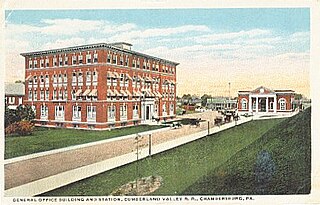
The Cumberland Valley Railroad was an early railroad in Pennsylvania, United States, originally chartered in 1831 to connect with Pennsylvania's Main Line of Public Works. Freight and passenger service in the Cumberland Valley in south central Pennsylvania from near Harrisburg to Chambersburg began in 1837, with service later extended to Hagerstown, Maryland, and then extending into the Shenandoah Valley to Winchester, Virginia. It employed up to 1,800 workers.

<span class="mw-page-title-main">Everett Railroad</span> Railroad in Hollidaysburg, Pennsylvania

The Everett Railroad is a shortline and heritage railroad that operates on ex-Pennsylvania Railroad trackage in the Hollidaysburg area of the U.S. state of Pennsylvania. It runs freight trains over two separate lines, one from Brooks Mill and Sproul, and the other, owned by the Morrison's Cove Railroad, from Roaring Spring to Curryville and Martinsburg.

References

  1. Pennsylvania Railroad, 1941 Division Accounting Maps Archived 2012-07-24 at archive.today
  2. "PRR Chronology, 1871" (PDF). (72.9  KiB), January 2005 Edition
  3. "PRR Chronology, 1872" (PDF). (86.1  KiB), February 2005 Edition
  4. "PRR Chronology, 1873" (PDF)., February 2005 Edition
  5. Hicks, W. Raymond. "Pennsylvania Railroad in Maryland." The Railway and Locomotive Historical Society Bulletin 85 (1952): 9-10.
  6. "PRR Chronology, 1876" (PDF). (116  KiB), April 2006 Edition
  7. PRR Corporate History: Pennsylvania Railroad Archived 2007-12-29 at archive.today
  8. "PRR Chronology, 1910" (PDF). (53.7  KiB), March 2005 Edition
  9. Pennsylvania Railroad (1923). Lists of Stations and Sidings and Instructions for Making Reports to the Superintendent Car Service. Philadelphia, Pa: Pennsylvania Railroad.
  10. Pennsylvania Railroad (1945). "C. T. 1000 Lists of Stations and Sidings and Instructions for Making Reports to the Superintendent Car Service" (PDF). www.multimodalways.org/index.html. Retrieved November 26, 2022.
  11. 1 2 3 4 5 6 Pennsylvania Railroad (1943). Middle Division Time-Table No. 4, 14 November 1943. Pennsylvania Railroad.
  12. 1 2 3 4 Photographic evidence