Ben Cruachan is a 1126 m mountain that is the highest point in Argyll and Bute, Scotland. It gives its name to the Cruachan Dam, a pumped-storage hydroelectric power station located in a cavern inside the mountain, Cruachan! is the battle cry for Highland clans Campbell and MacIntyre.
Beinn Dearg is a mountain in the Inverlael area of the Highlands of Scotland. It is most frequently climbed by following the River Lael up Gleann na Sguaib. Starting from near the head of Loch Broom, a path follows the glen to a bealach, which is about a kilometre north of the summit. From this bealach, the neighbouring peaks of Con a' Mheall and Meall na Ceapraichean may also be climbed. Eididh nan Clach Geala, which lies about 3 km north of Beinn Dearg, is also added in to complete a round of 4 Munros.

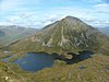
Ben Alder is the highest mountain in the remote area of the Scottish Highlands between Loch Ericht and Glen Spean. The vast summit plateau is home of one of Britain's highest bodies of standing water, Lochan a' Garbh Coire. It is the 25th highest Munro, and due to its remote location, one of the less frequently visited. Situated 19 km from Dalwhinnie and 15 km from Corrour railway station, it is commonly climbed in a two-day expedition, usually taking in its lower neighbour, Beinn Bheoil. There are two bothies near to the mountain: Culra Lodge to the northeast and Ben Alder Cottage to the south, both potentially providing shelter for walkers in the area. Ben Alder Cottage is reputed to be haunted by the ghost of a ghillie who hanged himself from the rafters.

Chno Dearg is a Scottish mountain situated 25 km east of Fort William, Highland in the Lochaber area of the Highland council area.

Beinn Dearg Mòr is a Corbett located in the middle of the Fisherfield Forest, near Dundonnell and Northwest Highlands in Scotland. It rises to an elevation of 906 metres (2,972 ft) above sea level.

Beinn a' Chlachair is a mountain in the Grampian Mountains of Scotland. It lies north of Loch Laggan, near the remote hamlet of Kinloch Laggan.

Beinn Dearg Bheag is a mountain in the Northwest Highlands, Scotland. It is located in the wild Dundonnell and Fisherfield Forest area of Wester Ross, a long way from any road or settlement.

Beinn Tarsuinn is a mountain in the Northwest Highlands of Wester Ross, Scotland. It lies in the heart of the remote Dundonnell and Fisherfield Forest.

Beinn Dearg is a mountain in the Grampian Mountains of Scotland. It lies north of the village of Blair Atholl in Perthshire.

Beinn nan Aighenan is a mountain in the Grampian Mountains of Scotland. It lies in Argyll and Bute, north of the village of Taynuilt.
Beinn Eunaich is a mountain in the Grampian Mountains of Scotland, located north of the village of Dalmally in Argyll and Bute.

Sgor Gaibhre is a mountain in the Grampian Mountains of Scotland. It lies on the border of Highland and Perth and Kinross, near Loch Ossian.

Beinn Talaidh is a peak on the Isle of Mull, Scotland, located in the mountainous centre of the Island.

Beinn na Gucaig is a mountain in the Grampian Mountains of Scotland, located south of Fort William in Lochaber.

Beinn a' Chochuill is a mountain in the Grampian Mountains of Scotland, located east of Loch Etive in Argyll and Bute.

Carn Dearg is a remote mountain in the Grampian Mountains of Scotland. It lies east of Rannoch Moor, on the border of Highland and Perthshire.

Beinn na h-Uamha is a mountain in the Northwest Highlands of Scotland. It lies in the Ardgour area of Lochaber, west of the village of Corran.

Beinn na h-Eaglaise is a mountain in the Northwest Highlands of Scotland. It lies in Wester Ross, south of the village of Torridon.

Beinn nan Caorach is a mountain in the Northwest Highlands of Scotland, It is located near the village of Corran in Lochalsh.
Aonach Beag is a 1,116-metre (3,661 ft) mountain in the Highlands of Scotland in the remote area between Loch Ericht and Loch Laggan located about 4 kilometres (2.5 mi) northwest of Ben Alder. Its prominence is 99 metres (325 ft) with its parent peak, Geal-Charn, about 1 kilometre (0.62 mi) to the east. In Gaelic, Aonach Beag means "little ridge" despite it being a Munro. It should not be confused with the better-known Munro near Ben Nevis, also called Aonach Beag, about 30 kilometres (19 mi) to the west.