An Gearanach

Last updated

An Gearanach
An Gearanach from Stob Coire a Chairn.jpg
An Gearanach (left) and An Garbhanach (right) from Stob Coire a' Chàirn
Highest point
Elevation 982 m (3,222 ft) [1]
Prominence 151 m (495 ft)
Parent peak Am Bodach
Listing Munro, Marilyn
Coordinates 56°45′30″N4°58′02″W / 56.75833°N 4.96733°W / 56.75833; -4.96733
Naming
English translationshort ridge or the complainer
Language of name Gaelic
PronunciationScottish Gaelic: [əŋʲˈkʲɛɾanəx]
English approximation: ənk-YERR-ə-nəkh
Geography
Lochaber UK relief location map.jpg
Red triangle with thick white border.svg
An Gearanach
Parent range Mamores
OS grid NN187669
Topo map OS Landranger 41, OS Explorer 392
Listed summits of An Gearanach
NameGrid refHeightStatus
An Garbhanach NN188665 975 m (3199 ft)Munro Top
The waterfall of An Steall Ban flows into Glen Nevis on An Gearanach's lower northern slopes. Steall waterfall.jpg
The waterfall of An Steall Bàn flows into Glen Nevis on An Gearanach's lower northern slopes.
Glen Nevis from the summit of An Gearanach Glen Nevis from An Gearanach.jpg
Glen Nevis from the summit of An Gearanach

An Gearanach is a Scottish mountain situated in the Mamore Forest, five and a half kilometres north of Kinlochleven in the Lochaber region of the Highland council area.

Contents

Overview

An Gearanach reaches a height of 982 metres (3222 feet) making it Munro number 167 in height order [2] and with a prominence of 151 metres it just qualifies as a Marilyn. It is part of a group of mountains commonly called the Mamores which lie between Loch Leven and Glen Nevis and consist of 10 Munros and two Corbetts. The translation of the mountains name from Gaelic is uncertain with some publications giving it as "short ridge" from "Geàrr Aonach" [3] while others give a translated name of "the complainer" [4] or "the sad place". [5]

Geography

The upper slopes of An Gearanach are basically a north-south summit ridge just over a kilometre in length with steep flanks which drop into the valleys of the Allt Coire a' Mhail to the west and the Allt Coire na Gabhalach to the east. At the northern end of the mountain are three ridges which go roughly NW, north and NE descending to upper Glen Nevis. To the south is a ridge which descends to the Bealach a' Chadah (857 metres) before continuing to the adjoining Munro of Stob Coire a' Chàirn. An Gearanach is a popular mountain, not just because of its Munro status but because it is part of one of the best and most exposed ridge walks in the whole of Scotland, the Ring of Steall. [6] This route takes in the three other Munros of Stob Coire a' Chàirn, Am Bodach and Sgurr a' Mhàim during a circuit of the Allt Coire a' Mhàil, a glen which feeds the An Steall Ban waterfall. The An Steall Bàn ("the white spout") is a fine sight as it drops 120 metres down the northern lower slopes of An Gearanach. [7] The base of the falls is passed on the approach to the mountain from Glen Nevis.

An Gearanach has a subsidiary peak, An Garbhanach ("rough ridge"), which lies 400 metres to the south: the two are connected by a narrow ridge which at one point is quite tricky as it tapers to a knife edge arête dropping into deep glens on either side and requires a good head for heights. There has always been some uncertainty about which is the highest point, with both An Gearanach and An Garbhanach given a height of 3,200 feet on pre metric maps in the 1970s. [8] An Garbhanach reaches a height of 975 metres and in 1921 was accidentally elevated to Munro status and An Gearanach reduced to a "top" due to the vagaries of old fashioned mapping techniques. The mistake was rectified in the 1933 revision of Munro's tables with an explanation that it had all been a mistake. [9] The northern slopes of An Gearanach require some care when descending from the mountain to Glen Nevis and there have been fatalities as walkers have left the stalkers path and tried to descend directly to Glen Nevis and got into difficulties on the crags above the An Steall Ban waterfall. [10]

Ascents

An Gearanach can be climbed from either Glen Nevis or Kinlochleven. The approach from Glen Nevis is shorter and has the advantage of approaching through the lovely Nevis gorge and past the foot of the An Steall Ban waterfall. After crossing the Water of Nevis on a wire suspension bridge and passing the foot of the waterfall, a stalkers path zig zags up the hillside to gain the NNE ridge and up to the summit. The approach from Kinlochleven involves firstly ascending Stob Coire a' Chàirn by the stalkers' path up Coire na Ba before continuing to An Gearanach giving an out and back trip of 14 kilometres. [11]

Related Research Articles

<span class="mw-page-title-main">Sgùrr a' Mhàim</span> Mountain in Scotland

Sgùrr a' Mhàim is a mountain of the Mamores range in the Scottish Highlands. It is directly south of Ben Nevis, on the other side of Glen Nevis. With a height of 1099 metres (3605 feet), Sgùrr a' Mhàim is a Munro and the second-highest peak in the Mamores. Its cap of quartzite stones give it a light grey appearance which can be mistaken for a covering of snow.

<span class="mw-page-title-main">Mamores</span>

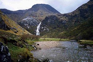
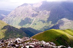
The Mamores are a group of mountains in the Lochaber area of the Grampian Mountains in the Scottish Highlands. They form an east–west ridge approximately fifteen kilometres in length lying between Glen Nevis to the north and Loch Leven to the south.

<span class="mw-page-title-main">Am Bodach</span> Mountain in Scotland

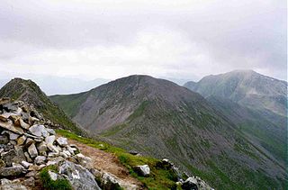
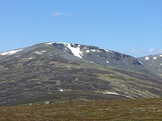
Am Bodach is a Scottish mountain which lies in the Mamores range, four kilometres north of Kinlochleven in the Highland council area.

<span class="mw-page-title-main">Stob Bàn (Mamores)</span> Mountain in Scotland

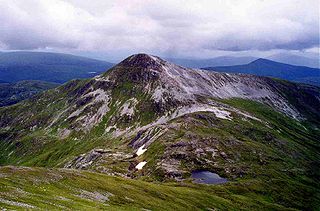
Stob Bàn is a Scottish mountain situated at the western end of the Mamores ridge, five and a half kilometres north-west of Kinlochleven. With a height of 999 metres it qualifies as a Munro. Stob Bàn is a distinctive sight when viewed from lower Glen Nevis with its sharp peak and capping of white quartzite rocks which are often mistaken for snow; its Gaelic name translates as White Peak or Light Coloured Peak.

<span class="mw-page-title-main">Mullach nan Coirean</span> Mountain in Scotland

Mullach nan Coirean or Sgùrr a' Chaorainn is one of the Mamores mountains in the Scottish Highlands. It reaches a height of 939 metres (3081 feet) and is the most westerly of the ten Munros in the Mamores. It has a lower peak to the west, Meall a' Chaorainn. To the east, it is linked to the neighbouring mountain Stob Bàn by a bealach at a height of 846 metres; these two Munros are often climbed together from Glen Nevis.

<span class="mw-page-title-main">Stob Coire a' Chàirn</span> Mountain in Scotland

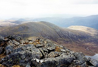
Stob Coire a’ Chàirn is a Scottish mountain situated in the Mamores range, 3.5 kilometres north of Kinlochleven. The mountain reaches a height of 981 metres (3218 feet) and is regarded as one of the more modest peaks of the ten Munros in the Mamores, indeed for many years it was not named on OS maps. Despite this, it is situated at a strategically important point and could be said to be the most central of the group with three ridges radiating out to other Munros. The mountains name translates from Gaelic as “Peak of the Corrie of the Cairn”.

<span class="mw-page-title-main">Stob Bàn (Grey Corries)</span>

Stob Bàn is a mountain situated in the Lochaber region of Highland, Scotland, 16 kilometres east of Fort William. It reaches a height of 977 metres (3205 feet) and lies in a group of hills known as the Grey Corries which includes three other Munros and nine Munro "Tops" along an eight kilometre ridge. The mountain's name translate as “White Peak”, while other sources give the translation as Light Coloured Peak with the hill being covered in light coloured schist scree, in contrast to the rest of the Grey Corries which are made up of grey quartzite scree. The mountain is a prominent conical shape, isolated from the rest of the group and distant from any main roads. It should not be confused with another Munro named Stob Bàn situated in the Mamores.

<span class="mw-page-title-main">Stob Coire Easain</span> Mountain in Scotland

Stob Coire Easain is a Scottish Munro mountain which reaches a height of 1115 metres (3658 feet), situated 18 kilometres east of Fort William. It stands on the western side of Loch Treig, along with its "twin", the Munro Stob a' Choire Mheadhoin. Collectively the pair are called "The Easains" or the "Stob Corries" and stand just one kilometre apart connected by a high col with an approximate height of 965 metres. The fine corrie of Coire Easain Beag lies in between the two mountains facing north west. Stob Coire Easain’s name translates from the Gaelic as “Peak of the Corrie of the Little Waterfall”. This mountain should not be confused with another Stob Coire Easain, a Munro “Top” on the Munro Stob Coire an Laoigh

<span class="mw-page-title-main">Gairich</span>

Gairich, sometimes Sgurr Gairoch, is a mountain in Lochaber in the Northwest Highlands of Scotland. It is on the southern side of Loch Quoich, with Glen Garry to the east and Glen Kingie to the south, 25 kilometres north-northwest of Fort William.

<span class="mw-page-title-main">Sròn a' Choire Ghairbh</span> Mountain in Scotland

Sròn a’ Choire Ghairbh is a Scottish mountain situated on the northern side of Loch Lochy, 13 kilometres north of Spean Bridge in the Highland Council area.

<span class="mw-page-title-main">Stob Ghabhar</span> Scottish mountain in Black Mount range

Stob Ghabhar is a mountain in the Scottish Highlands, part of the Black Mount group. It is a Munro with a height of 1,089.2 metres (3,573 ft). Stob Ghabhar lies nine kilometres (5.6 mi) northwest of Bridge of Orchy and stands on the border of the Argyll and Highland council areas.

<span class="mw-page-title-main">Meall na Teanga</span>

Meall na Teanga is a Scottish mountain located in the Highland council area, 11 km (7 mi) north of Spean Bridge.

<span class="mw-page-title-main">Stob a' Choire Odhair</span>

Stob a' Choire Odhair is a Scottish mountain situated eight kilometres north west of Bridge of Orchy on the border of the Argyll and Bute and Highland council areas.

<span class="mw-page-title-main">An Riabhachan</span> Mountain in Scotland

An Riabhachan is a Scottish mountain in the Skye and Lochalsh district of the Highland council area. It is situated 35 kilometres east of Kyle of Lochalsh standing in an isolated position at the western end of Loch Mullardoch, ten kilometres from any public road.

<span class="mw-page-title-main">Càrn nan Gobhar (Mullardoch)</span>

Càrn nan Gobhar is a mountain rising to 993 metres (3,258 ft) in the Northwest Highlands of Scotland. It stands on the northern side of Loch Mullardoch in the upper part of Glen Cannich, in a remote group of four Munros informally known as "The Mullardochs" which form the high ground between Loch Mullardoch and Loch Monar.

<span class="mw-page-title-main">Stob Choire Claurigh</span> Mountain in Scotland

Stob Choire Claurigh is a mountain in Lochaber in the Scottish Highlands, with a height of 1,177 metres (3,862 ft). It is part of the Grey Corries, near Ben Nevis, and lies about 16 km (10 mi) east of Fort William. It is described as one of the best ridge walks on the Scottish mainland.

<span class="mw-page-title-main">Chno Dearg</span> Mountain in Scotland

Chno Dearg is a mountain in the Lochaber area of the Scottish Highlands. It overlooks Glen Spean to the north and Loch Treig to the west. With a height of 1,046 metres (3,432 ft), it is classed as a Munro.

<span class="mw-page-title-main">Sgairneach Mhòr</span>

Sgairneach Mhòr is a Scottish mountain which lies in a group of seven Munros near the summit of the Pass of Drumochter and are known as the Drumochter mountains or informerly as the “A9 Munros”. The mountain is situated 13 km SSW of Dalwhinnie and four km east of the large Loch Ericht.

<span class="mw-page-title-main">Na Gruagaichean</span>

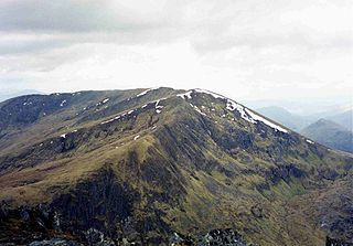
Na Gruagaichean is one of the Mamores mountains in the Scottish Highlands, between Glen Nevis to the north and the village of Kinlochleven to the south. It has twin peaks, the highest of which rises to 1,056 m (3,465 ft), and it is classed as a Munro. The mountain is one of the most accessible from the village, due in part to its nearness and a well-defined path leading most of the way to the summit.

<span class="mw-page-title-main">Skyline Scotland</span> Annual skyrunning race events

Skyline Scotland is a set of annual skyrunning races which take place on consecutive days in the mountains around Kinlochleven in Lochaber. The main races are the Mamores VK, the Ring of Steall Skyrace, the Ben Nevis Ultra and the Glen Coe Skyline.

References

Footnotes

  1. "walkhighlands An Gearanach". walkhighlands.co.uk. 2013. Retrieved 22 November 2013.
  2. www.scottishsport.co.uk. Archived 2011-07-16 at the Wayback Machine Gives Munros in height order.
  3. "The High Mountains of Britain and Ireland" Page 88 Gives translation as "Short Ridge".
  4. "The Magic of the Munros" Page 59 Gives translation as "The Complainer".
  5. "100 Best Routes on Scottish Mountains" Page 64 Gives translation as "The Sad Place".
  6. "The Munros, Scotland's Highest Mountains" Page 70 "Ring of Steall ... Seven tops make up this superb round".
  7. www.world-waterfalls.com. Gives details of An Steall Bàn.
  8. "Hamish's Mountain Walk" Page 164 Mentions both tops having height of 3,200 feet in the 1970s.
  9. The Angry Corrie. Archived August 27, 2006, at the Wayback Machine Tricky Tops and Obscurities in Munro’s Tables - Gives details of An Gearanach.
  10. www.mountaineering-scotland.org.uk. Alarm Bells on the Ring of Steall.
  11. "The Munros" Page 68 Gives details of Ascents.