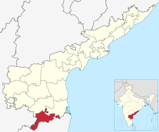
Chittoor district, is one of the four districts in the Rayalaseema region of the Indian state of Andhra Pradesh. The district headquarters is located at Chittoor. It has a population of 4,170,468 according to 2011 census of India. Chittoor district has many major temples including Tirupati, Srikalahasti, Kanipakam, and other temples. It lies in the Poini river valley of southernmost Andhra Pradesh along the Chennai – Bangalore section of Chennai-Mumbai highway. Chittoor district is a major market centre for mangoes, grains, sugarcane, and peanuts. Sricity integrated business city lies in Satyavedu mandal; it acts as a major industrial hub for Chittoor district as well as Andhra Pradesh as a whole.
Kurnool District is one of the four districts in the Rayalaseema region of the Indian state of Andhra Pradesh. The district is located in the west-central part of the state and is bounded by Mahabubnagar district of Telangana in the north, Raichur district of Karnataka in the northwest, Bellary district of Karnataka in the west, Ananthapur district in the south, YSR Kadapa district in the South East and Prakasham district in the east. The city of Kurnool is the headquarters of the district. It has a population of 4,053,463 of which 28.35% were urban as of 2011. The district is the second largest by area and seventh largest by population in the state.

Malkajgiri is a suburb of Hyderabad, Telangana, India. It is located in Medchal–Malkajgiri district and is the headquarters of Malkajgiri mandal in Malkajgiri revenue division. Erstwhile Malkajgiri panchayat was upgraded to a municipality in 1965 and became a municipal corporation in 1985. It was merged into the Greater Hyderabad Municipal Corporation in 2007. It was a part of Ranga Reddy district before the re-organisation of districts in 2016.

Kankipadu is a Town in Krishna district of the Indian state of Andhra Pradesh. It is also the mandal headquarters of Kankipadu mandal in Vijayawada revenue division. The town is located on the banks of the Paleru River which is a tributary of the Krishna River.

For people with the surname, see Boath (surname).

Giddaluru is a town in the Prakasam district of the Indian state of Andhra Pradesh. It is the mandal headquarters of the Giddaluru mandal in Markapur revenue division.It was part of kurnool district till 1969 later it was merged into Prakasam district in 1970. Till 2008 it was under Nandyal parliament segment after delimitation it was moved to Ongole MP segment. Giddalur is also known as "3 zilla la muddu bidda " because during britishers rule it was in kadapa district later moved to kurnool then in 1970 merged in prakasam district. Giddalur is the only constituency in coastal districts which has Rayalseema culture,slang and traditions. Giddalur town has good transport connectivity to Nandyal,Markapur,Ongole,Kurnool,Kadapa.
Bathalapalle is a village in Anantapur district of the Indian state of Andhra Pradesh. It is the mandal headquarters of Bathalapalle mandal in Dharmavaram revenue division. It is about 25 kilometres south east of Anantapur on National Highway 205.

Tsundur is a village in Guntur district of the Indian state of Andhra Pradesh. It is the mandal headquarters of Tsundur mandal in Tenali revenue division.
Denduluru is a mandal in West Godavari district in the state of Andhra Pradesh in India.
Kundurpi is a village in Anantapur district of the Indian state of Andhra Pradesh. It is the headquarters of Kundurpi mandal in Kalyandurg revenue division.
Kambadur is a village in Anantapur district of the Indian state of Andhra Pradesh. It is the headquarters of Kambadur mandal in Kalyandurg revenue division.
Roddam is a village in Anantapur district in the state of Andhra Pradesh in India.

Bapatla mandal is one of the 57 mandals in Guntur district of the state of Andhra Pradesh, India. It is under the administration of Tenali revenue division and the headquarters are located at Bapatla. The mandal is bounded by Kakumanu, Ponnur, Karlapalem mandals of Guntur district. It also shares borders with Prakasam district and a portion of it lies on the coast of Bay of Bengal.

Machilipatnam mandal is one of the 50 mandals in Krishna district of the Indian state of Andhra Pradesh. It is under the administration of Machilipatnam revenue division and the headquarters are located at Machilipatnam town. The mandal is bounded by Bantumilli, Pedana, Gudur, Ghantasala, Challapalli and Koduru mandals.

Ibrahimpatnam mandal is one of the fifty mandals that constitute the Krishna district of the State of Andhra Pradesh in India. It is under the administration of the Vijayawada revenue division and the mandal headquarters are located at Ibrahimpatnam town. The mandal is located on the banks of Krishna River and is bounded by Kanchikacherla, Veerullapadu, G. Konduru and Vijayawada (rural) mandals. The mandal is also a part of the Andhra Pradesh Capital Region under the jurisdiction of APCRDA.

Nagayalanka mandal is one of the 50 mandals in Krishna district of the Indian state of Andhra Pradesh. It is under the administration of Machilipatnam revenue division and has its headquarters at Nagayalanka. The mandal is bounded by Avanigadda and Koduru mandals. It lies at the mouths of Krishna River where it empties into Bay of Bengal.
Pachipenta mandal is one of the 34 mandals in Vizianagaram district of the Indian state of Andhra Pradesh. It is administration under Parvathipuram revenue division and headquartered at Pachipenta. The mandal is bounded by Salur, Ramabhadrapuram and Mentada mandals. A portion of it also borders the state of Odisha.

Bhattiprolu mandal is one of the 57 mandals in Guntur district of the Indian state of Andhra Pradesh. It is under the administration of Tenali revenue division and the headquarters are located at Bhattiprolu. The mandal is situated on the banks of Krishna River, bounded by Kollur, Vemuru, Cherukupalle, Nagaram and Repalle mandals. The mandal headquarters ten villages are included in Andhra Pradesh Capital Region.

Macherla mandal is one of the 57 mandals in Guntur district of the Indian state of Andhra Pradesh. It is under the administration of Gurazala revenue division and the headquarters are located at Macherla. The mandal is bounded by Rentachintala, Durgi and Veldurthi mandals and a portion of the mandal also borders the state of Telangana.

Biccavolu mandal is one of the 65 mandals in East Godavari district of the Indian state of Andhra Pradesh. It is under the administration of Rajahmundry revenue division and the headquarters are located at Biccavolu village. Biccavolu Mandal is bounded by Rayavaram Mandal towards South, Pedapudi Mandal towards East, Anaparthy Mandal towards west, Ramachandrapuram Mandal towards north. It is located ata distance of 41 kilometres from Rajahhmundry.

