
Belconnen is a district in the Australian Capital Territory in Australia. The district is subdivided into 27 divisions (suburbs), sections and blocks. As at the 2021 census, the district had a population of 106,061 people; and was the most populous district within the Australian Capital Territory (ACT).

Bike lanes (US) or cycle lanes (UK) are types of bikeways (cycleways) with lanes on the roadway for cyclists only. In the United Kingdom, an on-road cycle-lane can be firmly restricted to cycles or advisory. In the United States, a designated bicycle lane or class II bikeway (Caltrans) is always marked by a solid white stripe on the pavement and is for 'preferential use' by bicyclists. There is also a class III bicycle route, which has roadside signs suggesting a route for cyclists, and urging sharing the road. A class IV separated bike way (Caltrans) is a bike lane that is physically separate from motor traffic and restricted to bicyclists only.

Bicycle transportation planning and engineering are the disciplines related to transportation engineering and transportation planning concerning bicycles as a mode of transport and the concomitant study, design and implementation of cycling infrastructure. It includes the study and design of dedicated transport facilities for cyclists as well as mixed-mode environments and how both of these examples can be made to work safely. In jurisdictions such as the United States it is often practiced in conjunction with planning for pedestrians as a part of active transportation planning.
Aranda is a suburb in the district of Belconnen, in the Australian capital city of Canberra. Located at the western foot of Black Mountain and bounded on two sides by nature park, the suburb is characterised by its bush setting. During the planning and development of the suburb, a large proportion of large native trees – predominantly eucalypts – were left in place.
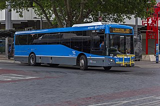
ACTION is a bus operator in Canberra, Australia, and is owned by the Government of the Australian Capital Territory.

Belconnen is the most inner suburb of the larger district of Belconnen in Canberra, Australia. Sharing its name with the larger district which encapsulates it, the suburb is surrounded with well developed infrastructure, and planning which allows it sunset views from the Brindabellas on its western side. The suburb contains important amenities for the District of Belconnen including the Belconnen Town Centre and Lake Ginninderra as well as its own well populated residential areas. It is bounded by Ginninderra Drive, Aikman Drive, Eastern Valley Way, Belconnen Way and Coulter Drive. It has a number of parks such as Margaret Timpson Park, Eastern Valley Oval and on the foreshores of Lake Ginninberra, Diddams Close Park and John Knight Memorial Park.

Gungahlin Drive Extension (GDE) is a motorway grade road, located in the Belconnen district of Canberra, Australia. It is 8.3 kilometres long and extended the previously existing Gungahlin Drive from the Barton Highway in the district of Gungahlin to the Glenloch Interchange to connect with the Tuggeranong Parkway, Parkes Way, and William Hovell Drive. Early in the planning stages, the GDE was to instead be designated the John Dedman Parkway.

A cycle track or cycleway (British) or bikeway, sometimes historically referred to as a sidepath, is a separate route for cycles and not motor vehicles. In some cases cycle tracks are also used by other users such as pedestrians and horse riders. A cycle track can be next to a normal road, and can either be a shared route with pedestrians or be made distinct from both the pavement and general roadway by vertical barriers or elevation differences.

The Scotchmans Creek Trail is a shared use path for cyclists and pedestrians, which follows Scotchmans Creek through the eastern suburbs of Melbourne, Victoria, Australia.

Cycling in Canada is experienced in various ways across a geographically huge, economically and socially diverse country. Among the reasons for cycling in Canada are for practical reasons such as commuting to work or school, for sports such as road racing, BMX, mountain bike racing, freestyle BMX, as well as for pure recreation. The amount and quality of bicycle infrastructure varies widely across the country as do the laws pertaining to cyclists such as bicycle helmet laws which can differ by province.

Cycling infrastructure is all infrastructure cyclists are allowed to use. Bikeways include bike paths, bike lanes, cycle tracks, rail trails and, where permitted, sidewalks. Roads used by motorists are also cycling infrastructure, except where cyclists are barred such as many freeways/motorways. It includes amenities such as bike racks for parking, shelters, service centers and specialized traffic signs and signals. The more cycling infrastructure, the more people get about by bicycle.
The history of cycling infrastructure starts from shortly after the bike boom of the 1880s when the first short stretches of dedicated bicycle infrastructure were built, through to the rise of the automobile from the mid-20th century onwards and the concomitant decline of cycling as a means of transport, to cycling's comeback from the 1970s onwards.

Cycleway 3 (C3) is a cycle route in London, England. It is part of the Cycleway network coordinated by TfL. It runs from Barking in the east to Lancaster Gate in central London. It is a popular route with both commuter and leisure cyclists, passing a number of major destinations in London along its route. For almost the entire route, cyclists are separated from other traffic in segregated cycle lanes, and cycling infrastructure has been provided at major interchanges. The cycleway, originally called Cycle Superhighway 3, was renamed to Cycleway 3 in January 2023.

Terminology related to road transport—the transport of passengers or goods on paved routes between places—is diverse, with variation between dialects of English. There may also be regional differences within a single country, and some terms differ based on the side of the road traffic drives on. This glossary is an alphabetical listing of road transport terms.

A bicycle highway, also known as a cycling superhighway, fast cycle route or bike freeway, is an informal name for a bicycle path that is meant for long-distance traffic. There is no official definition of a bicycle highway. The characteristics of a cycle motorway mentioned by authorities and traffic experts include an absence of single-level intersections with motorized traffic, a better road surface and the absence of traffic lights. Bicycle highways are mentioned in connection with traffic jam. Owing to higher average speeds than normal cycling infrastructure, they provide an alternative to the car in commuter traffic. Often a cycle motorway follows the route of a railway or other linear infrastructure.
The city of Madrid has been increasing in the last years its network of bicycle paths. In 2016, there were 195 km of cycling routes. The former city council had been planning to build 400 km more for the year 2024 despite a very vocal opposition to the construction of segregated infrastructure by a significant part of the local cycling community. However now with the new right wing mayor elected in 2019 the city is set to be the only capital in the world where bicycle lanes are being removed again.
Cycling in Prague is a popular leisure activity and a not so common mode of transport within the capital city of the Czech Republic. However, levels of utility cyclists have been rising recently. In 2018, 2% of people commuted by bike in Prague. As of 2017, there were 178 km (111 mi) of protected cycle paths and routes in the city. Also, there are 48 km (30 mi) of bike lanes and 24 km (15 mi) of specially marked bus lanes that can be used by cyclists.

Cycling infrastructure in the Canadian city of Halifax, Nova Scotia includes most regular streets and roads, bike lanes, protected cycle tracks, local street bikeways, and multi-use pathways.

Cycling in Canberra, the capital city of Australia, is a popular means of transportation, sporting and recreational pass time. Commuting in the city is supported by an extensive network of urban cycleways and on-street bicycle lanes. As a city established in the 20th century, Canberra's development was heavily influenced by the automobile for much of its history. The popularity of cycling in the city has increased dramatically in the 21st century with growing awareness of environmental issues, government policy supporting active transport and investment in cycling infrastructure. This has led to the development of a strong cycling culture.
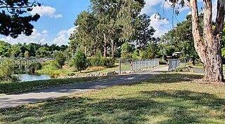
The Sullivans Creek shared path is a 3.7 km (2.3 mi) commuter cycleway in Canberra, Australia. Opened in December 1973, the path was the first off-street cycleway in Canberra and forms a trunk route from which the network extends to the districts of North Canberra, Belconnen and Gungahlin. Transport Canberra's designated cycling routes C1, C3 and C6 all traverse sections of the path, which is by far the busiest cycle route in the city.

