The Mozambique Channel is an arm of the Indian Ocean located between the Southeast African countries of Madagascar and Mozambique. The channel is about 1,700 km long and 419 km across at its narrowest point, and reaches a depth of 3,292 m (10,801 ft) about 230 km off the coast of Mozambique. A warm current, the Mozambique Current, flows in a southward direction in the channel, leading into the Agulhas Current off the east coast of Southern Africa.
Antsiranana, named Diego-Suarez prior to 1975, is a city in the far north of Madagascar. Antsiranana is the capital of Diana Region. It had an estimated population of 115,015 in 2013.

Nosy Boraha, also known as Sainte-Marie, main town Ambodifotatra, is an island off the east coast of Madagascar. The island forms an administrative district within Analanjirofo Region, and covers an area of 222 km2. It has a population estimated at 30,000.
Cape Sainte Marie, formerly known as Cape Romain and Cape St. Mary, is the southernmost point of Madagascar. It is situated in the Androy region 42 kilometres (26 mi) from Tsiombe. It is the location of the Cap Sainte-Marie Special Reserve, a nature reserve which occupies most of the cape and was created in 1962.
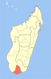
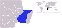
Androy is the most southerly region of Madagascar. It covers an area of 19,540 km2, and had a population of 903,376 inhabitants in 2018. The administrative capital is Ambovombe-Androy.
Tsiombe is a municipality and a district of Androy in Madagascar.
Ambovombe-Androy, or just Ambovombe, is a city in the far south of Madagascar, and the capital of the Androy region. Ambovombe has now acquired city status with an officially estimated population in 2018 of 114,230.
The Pirate Round was a sailing route followed by certain, mainly English, pirates, during the late 17th century and early 18th century. The course led from the western Atlantic, parallel to the Cape Route around the southern tip of Africa, stopping at Madagascar, then on to targets such as the coast of Yemen and India. The Pirate Round was briefly used again during the early 1720s. Pirates who followed the route are sometimes referred to as Roundsmen. The Pirate Round was largely co-extensive with the routes of the East India Company ships of Britain and other nations.
Berevo is a rural municipality in Madagascar. It belongs to the district of Belo sur Tsiribihina, which is a part of Menabe Region. The population of the commune was estimated to be approximately 3,000 in 2001 commune census.
Kopoky is a town and commune in Madagascar. It belongs to the district of Beloha, which is a part of Androy Region. The population of the commune was estimated to be approximately 15,000 in 2001 commune census.
Tranovaho is a town and commune in Madagascar. It belongs to the district of Beloha, which is a part of Androy Region. The population of the commune was estimated to be approximately 13,000 in 2001 commune census.
Faux Cap or Betanty is a municipality in Madagascar. It belongs to the district of Tsiombe, which is a part of the Androy Region. The population of the commune was estimated to be approximately 16,000 in the 2001 commune census.
Mahatalaky is a rural commune in Madagascar. It belongs to the district of Taolanaro, which is a part of Anosy Region. It is situated at 35 km from Fort Dauphin. The population of the commune was estimated to be approximately 25,000 in 2001 commune census.

Imishli is a city and the capital of the Imishli District of Azerbaijan.
Beloha District is a district in the Androy Region, located in southeastern Madagascar. The district has an area of 4,787 km2 (1,848 sq mi), and the estimated population in 2020 was 167,650.
Tsiombe District is a district in the Androy Region, located in southeastern Madagascar. Tsiombe includes the Cape Sainte-Marie, the southernmost point of Madagascar.
Tsiombe is a municipality and a district of Androy in Madagascar. The district has an area of 3,316 km2 (1,280 sq mi), and the estimated population in 2020 was 158,954.
Soanierana Ivongo is a district, which is a part of Analanjirofo Region, Madagascar. The population of the district was estimated to be 143,687 for 2018.