
Interstate 526 (I-526) is a 19.56-mile (31.48 km) auxiliary route of I-26, providing a partial beltway around Charleston, South Carolina, in the United States. The route serves several purposes, firstly, as a bypass for through traffic on U.S. Route 17 (US 17) to avoid downtown Charleston, and, secondly, for traffic on I-26 bound for the coastal towns located north and south of Charleston. The route is not yet complete, as the western terminus it is planned for the route to be extended an additional 10 miles (16 km). After the eastern terminus, the roadway continues as a short business route, known as Interstate 526 Business.
The South Carolina State Highway System is the fourth largest state-maintained system of state highways in the country. It consists of Interstates, U.S. highways, state highways, and secondary roads, totaling approximately 41,500 miles (66,800 km).

The Arthur Ravenel Jr. Bridge is a cable-stayed bridge over the Cooper River in South Carolina, US, connecting downtown Charleston to Mount Pleasant. The bridge has a main span of 1,546 feet (471 m), the third longest among cable-stayed bridges in the Western Hemisphere. It was built using the design–build method and was designed by Parsons Brinckerhoff.

The Cooper River Bridges were a pair of cantilever truss bridges that carried traffic over the Cooper River in Charleston, South Carolina, United States. The first bridge opened in 1929, a second one opened in 1966 to relieve traffic congestion. The Grace Memorial Bridge was designed and constructed by a private company known as Cooper River Bridge, Inc, and the Pearman Bridge was designed by HNTB Corporation and constructed by SCDOT.

The Paul Gelegotis Bridge, also known as the Stono Bridge, is located in Charleston, South Carolina, United States; it connects James Island and Johns Island on SC 700. This bridge opened in late 2003, on the historically significant site of a series of former Stono Bridges.

The Baltimore Harbor Tunnel is a pair of two-lane road tunnels carrying I-895 under the Patapsco River southeast of downtown Baltimore, Maryland.

Interstate 85 Business is a business loop of the Interstate Highway System. It is entirely a freeway running along the old route of I-85 in the vicinity of Spartanburg, South Carolina, United States. It is the only freeway to connect with I-585, which is now an isolated piece of the Interstate Highway System.

South Carolina Highway 22 (SC 22), also known as the Conway Bypass and Veterans Highway, is a four lane freeway that connects US 501 north of Conway, South Carolina, to US 17 in Myrtle Beach. The road was opened to traffic on May 4, 2001, six months ahead of schedule. It is slated to become part of Interstate 73 in the future. The road largely meets Interstate Highway standards, but in order to support increased Interstate traffic, its shoulders would need to be expanded to standard width.
WYBB is a commercial radio station licensed to Folly Beach, South Carolina and serving the Charleston metropolitan area and the South Carolina Lowcountry. It broadcasts a mainstream rock radio format and is owned by L. M. Communications of South Carolina, Inc. The radio studios and offices are on Windermere Boulevard in Charleston west of the Ashley River. On weekday mornings, WYBB carries the syndicated Bubba The Love Sponge show from Florida.
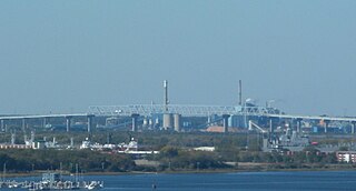
The Don N. Holt Bridge is a parallel chord, three-span continuous, modified Warren-type truss bridge that carries Interstate 526 (I-526) over the Cooper River between Charleston and North Charleston. It was built in 1992 by the South Carolina Department of Transportation and was designed by HNTB Corporation.

The James B. Edwards Bridge, also referred to as the Wando River Bridge, is a pair of pre-cast post-tensioned concrete box girder bridges that span the Wando River between Mount Pleasant and Daniel Island on Interstate 526 (I-526) in South Carolina.
South Carolina Highway 30 is a 3.050-mile-long (4.908 km) freeway in Charleston, South Carolina. The freeway travels from SC 171 on James Island to U.S. Route 17 (US 17) in downtown Charleston.

Interstate 26 (I-26) is a South Carolina Interstate highway running generally east–west from near Landrum, in Spartanburg County, to U.S. Route 17 (US 17), in Charleston, South Carolina. It is also the longest Interstate Highway in South Carolina.

The John F. Limehouse Memorial Bridge, located about 15 miles (24 km) west of downtown Charleston, South Carolina, was completed in 2003. It replaced an obsolete low-level swing bridge over the Stono River. The current bridge, which crosses a channel between Johns Island and St. Andrews Parish, an area generally called West Ashley, was completed under a partnership between the South Carolina Department of Transportation (SCDOT) and the United States Coast Guard.

U.S. Highway 17 (US 17) is a part of the United States Numbered Highway System that runs north–south from Punta Gorda, Florida to Winchester, Virginia. In South Carolina, it is a 221-mile (356 km) major highway that travels near the Atlantic Ocean. Beginning from the Georgia state line at the Savannah River, US 17 enters South Carolina in Jasper County, where it intersects with Interstate 95 (I-95). The route goes through Hardeeville. It merges with I-95 until Point South, then heads east into Beaufort County, through the ACE Basin, and eventually reaches Charleston. There, US 17 crosses the Ashley and Cooper rivers, crossing the Arthur Ravenel Jr. Bridge and becoming a major route through Mount Pleasant. Continuing through the Francis Marion National Forest, it reaches Georgetown. Then it follows the Grand Strand, bypassing Myrtle Beach before entering North Carolina near Calabash.

Interstate 73 (I-73) is the designation for a future Interstate Highway in the US state of South Carolina. When completed, it will connect the Grand Strand area with the state's Interstate system.

Dickabram Bridge is a heritage-listed road-and-rail bridge over the Mary River between Miva and Theebine, both in the Gympie Region, Queensland, Australia. It was the major bridge on the Kingaroy railway line. It was designed by Henry Charles Stanley and built from 1885 to 1886 by Messrs Michael McDermott, Owens & Co. It is also known as Mary River Bridge (Miva). The bridge was registered on the former Register of the National Estate in 1988.

The Port of Charleston is a seaport located in South Carolina in the Southeastern United States. The port's facilities span three municipalities—Charleston, North Charleston, and Mount Pleasant—with six public terminals owned and operated by the South Carolina Ports Authority (SCPA). These facilities handle containers, motor vehicles and other rolling stock, non-containerized goods and project cargo, as well as Charleston's cruise ship operation. Additional facilities in the port are privately owned and operated, handling bulk commodities like petroleum, coal and steel.

The Cherry Street lift bridge over the Keating Channel was the smaller of two bascule lift bridges on Cherry Street, in Toronto, Ontario, Canada. The bridge spanned the canalized mouth of the Don River where it empties into Toronto Harbour. It was the fourth bridge at that location, before being replaced by the Cherry Street North bridge.

The Wappoo Creek Bridge is a bridge that connects the cities of Charleston and James Island in South Carolina.

