Related Research Articles
Budapest is an unincorporated community in Ripley County, in the U.S. state of Missouri.
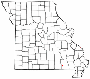
Bardley is an unincorporated community on the Oregon/Ripley county line in the U.S. state of Missouri. It is located on Missouri Route J approximately two miles north of U.S. Route 160 and fourteen miles east of Alton.

Gatewood is an unincorporated community in southwest Ripley County, Missouri, United States. It is located approximately fourteen miles west-southwest of Doniphan on Route 142.
Pine is a small unincorporated community in western Ripley County, Missouri, United States. It is located on a county road in the Mark Twain National Forest, approximately sixteen miles northwest of Doniphan.
Beaverdam is an unincorporated community in Ripley County, in the U.S. state of Missouri.
Burr is an unincorporated community in Ripley County, in the U.S. state of Missouri.
Carie is an unincorporated community in Ripley County, in the U.S. state of Missouri.
Flatwoods is an unincorporated community in Ripley County, in the U.S. state of Missouri.
Gamburg is an unincorporated community in Ripley County, in the U.S. state of Missouri.
Handy is an unincorporated community in the northwest corner of Ripley County, in the U.S. state of Missouri.
Leibig is an unincorporated community in southwestern Ripley County, in the U.S. state of Missouri. The community is located approximately eight miles southwest of Doniphan and three miles north of the Missouri-Arkansas border. The Fourche River is just west of the village.
Martinsburg is an extinct town in Ripley County, in the U.S. state of Missouri.
Owenmont is an unincorporated community in Ripley County, in the U.S. state of Missouri.
Ponder is an extinct town in southwestern Ripley County, in the U.S. state of Missouri. The GNIS classifies it as a populated place. The community is located on Missouri Route 142 between Doniphan to the east and Gatewood to the west. Fourche Creek passes just east of the site.
Pratt is an unincorporated community in southwest Ripley County, in the U.S. state of Missouri. The community lies six miles south of Doniphan on Missouri Route A, 1.5 miles north of the Arkansas line and one mile west of the Current River.
Purman is an unincorporated community in Ripley County, in the U.S. state of Missouri.
Torch is an unincorporated community in Thomas Township, Ripley County, in the U.S. state of Missouri. The community is located in Ripley County's southeast.
Tucker is an extinct town in southwestern Ripley County, in the U.S. state of Missouri. The GNIS classifies it as a populated place. The community lies on Missouri Route Z, south of Gatewood and three miles north of the Missouri-Arkansas border.
Gatewood Township is an inactive township in Ripley County, in the U.S. state of Missouri.
Pine Township is an inactive township in Ripley County, in the U.S. state of Missouri.
References
- ↑ U.S. Geological Survey Geographic Names Information System: Bennett
- ↑ Missouri Atlas & Gazetteer, DeLorme, 1998, First edition, p. 66, ISBN 0-89933-224-2
- ↑ "Post Offices". Jim Forte Postal History. Retrieved December 14, 2016.
- ↑ "Ripley County Place Names, 1928–1945". The State Historical Society of Missouri. Archived from the original on June 24, 2016. Retrieved December 14, 2016.
Municipalities and communities of Ripley County, Missouri, United States | ||
|---|---|---|
| Cities |  | |
| Townships | ||
| CDPs | ||
| Other unincorporated communities | ||
| Ghost towns | ||
| Footnotes | ‡This populated place also has portions in an adjacent county or counties | |
36°44′01″N91°00′16″W / 36.73361°N 91.00444°W
| | This Ripley County, Missouri state location article is a stub. You can help Wikipedia by expanding it. |