Liberia, officially the Republic of Liberia, is a country on the West African coast. It is bordered by Sierra Leone to its northwest, Guinea to its north, Ivory Coast to its east, and the Atlantic Ocean to its south and southwest. It has a population of around 5 million and covers an area of 43,000 square miles (111,369 km2). The country's official language is English; however, over 20 indigenous languages are spoken, reflecting the country's ethnic and cultural diversity. The capital and largest city is Monrovia.

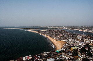
Monrovia is the capital city of the West African country of Liberia. Founded in 1822, it is located on Cape Mesurado on the Atlantic coast and as of the 2008 census had 1,010,970 residents, home to 29% of Liberia’s total population. As the nation's primate city, Monrovia is the country's economic, financial and cultural center; its economy is primarily centered on its harbor and its role as the seat of Liberian government.

Montserrado County is a county in the northwestern portion of the West African nation of Liberia containing its national capital, Monrovia. One of 15 counties that comprise the first-level of administrative division in the nation, it has 17 sub political districts. As of the 2008 Census, it had a population of 1,118,241, making it the most populous county in Liberia. The area of the county measures 1,912.7 square kilometres (738.5 sq mi), the smallest in the country. Bensonville serves as the capital.

Grand Cape Mount is a county in the northwestern portion of the West African nation of Liberia. One of 15 counties that constitute the first-level of administrative division in the nation, it has five districts. Robertsport serves as the capital with the area of the county measuring 5,162 square kilometres (1,993 sq mi). As of the 2008 Census, it had a population of 129,817, making it the eighth most populous county in Liberia. The county is bordered by Gbarpolu County to the northeast and Bomi County to the southeast. The northern part of Grand Cape Mount borders the nation of Sierra Leone, while to the west lies the Atlantic Ocean.
Greenville is the capital of Sinoe County in southeastern Liberia and lies on a lagoon near the Sinoe River and the Atlantic Ocean. It is located about 150 miles southeast of Monrovia. As of the 2008 national census, the population stood at 16,434.

Gbarnga is the capital city of Bong County, Liberia, lying north east of Monrovia. During the First Liberian Civil War, it was the base for Charles Taylor's National Patriotic Front of Liberia. Cuttington College, a private, Episcopal-affiliated institution, is located near the town. Its campus was once home to the Africana Museum, which was destroyed during the civil war.

Bomi is a county in the northwestern portion of the West African nation of Liberia. The county was established in 1984. The county's area is 746 square miles (1,900 km2).

Bong is a county in the north-central portion of the West African nation of Liberia. One of 15 counties that comprise the first-level of administrative division in the nation, it has twelve districts. Gbarnga serves as the capital. The area of the county measures 8,772 square kilometres (3,387 sq mi). As of the 2008 Census, it had a population of 328,919, making it the third-most populous county in Liberia. The county was organized in 1964 and is important for its mining industry.

Margibi is a county on the north to central coast of Liberia. One of 15 counties that constitute the first-level of administrative division in the nation, it has five districts. Kakata serves as the capital with the area of the county measuring 2,616 square kilometres (1,010 sq mi). As of the 2008 Census, it had a population of 199,689, making it the sixth most populous county in Liberia.

Zwedru is the capital of Grand Gedeh County, one of the 15 counties in Liberia. Zwedru is located in Tchien District of Grand Gedeh County, near the Cavalla River in the country's south-eastern region and near the border with Côte d'Ivoire. It is located 350 miles southeast from the capital city of Monrovia. The town is a stronghold of the Krahn tribe.
Careysburg District is one of four districts located in Montserrado County, Liberia. Bensonville is the capital, and the total district population is 28,463.
Greater Monrovia is one of four districts located in Montserrado County, Liberia. It contains the country's capital Monrovia. It recorded a population of 970,824 in the 2008 census.
St. Paul River is a district located in Montserrado County, Liberia. It recorded a population of 71,831 in the 2008 census. It has no official administrative status. Its inhabitants are primarily Christians and members of the Bassa, Dey, or Kpelle tribes. Farming and fishing are the main economic activities along with some small scale trading. The district has one paved road.

The Minister of Foreign Affairs is a cabinet minister of Liberia in charge of the Ministry of Foreign Affairs, a government ministry responsible for conducting foreign relations of the country.
West Point is a township of the Liberian capital city of Monrovia, located on a 0.53 km2 peninsula which juts out into the Atlantic Ocean between the Mesurado and Saint Paul rivers. West Point is one of Monrovia's most densely populated slums.
Caldwell is a township located in Montserrado County, Liberia. Caldwell was one of the four townships established in the first wave of colonization. It is listed as one of the original settlements comprising the Commonwealth of Liberia in the 1839 Constitution, which was drafted by the American Colonization Society. The name comes from Elias B. Caldwell and family, about 1816, Presbyterians in what became Caldwell, New Jersey.
The Ministry of Foreign Affairs is a cabinet ministry of Liberia responsible for directing Liberia's external relations and the management of its international diplomatic missions. The ministry is located in Monrovia, Liberia's capital.
New Kru Town is a northwestern coastal suburb of Monrovia, Liberia.
The following is a timeline of the history of the city of Monrovia, Liberia.
Commonwealth is a district in Montserrado County in Liberia. The population was 11,876 in 2008, according to Population and Housing Census.