
Adams County is a county in the U.S. state of Iowa. As of the 2020 census, the population was 3,704, making it Iowa's least-populous county. Its county seat is Corning.

Woodbury County is a county located in the U.S. state of Iowa. As of the 2020 census, the population was 105,941, making it the sixth-most populous county in Iowa. The county seat is Sioux City.

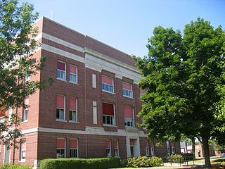
Wapello County is a county located in the U.S. state of Iowa. As of the 2020 census, the population was 35,437. The county seat is Ottumwa. The county was formed on February 17, 1843, and named for Wapello, a Meskwaki chief.
Ringgold County is a county located in the U.S. state of Iowa. As of the 2020 census, the population was 4,663, making it the Iowa county with the second-smallest population. The county seat is Mount Ayr. The county is named after Maj. Samuel Ringgold, a hero of the Battle of Palo Alto fought in May 1846, during the Mexican–American War. It is one of the 26 Iowa counties with a name that is unique across the nation.

Pottawattamie County is a county located in the U.S. state of Iowa. At the 2020 census, the population was 93,667, making it the tenth-most populous county in Iowa. The county takes its name from the Potawatomi Native American tribe. The county seat is Council Bluffs.

Pocahontas County is a county located in Iowa, United States. As of the 2020 census the population was 7,078, making it the state's ninth-least populous county. The county seat is Pocahontas. The county was formed in 1851.

Palo Alto County is a county located in the U.S. state of Iowa. As of the 2020 census, the population was 8,996. The county seat is Emmetsburg. It is named after the Battle of Palo Alto, the first major battle of the Mexican–American War.

Louisa County is a county located in the U.S. state of Iowa. As of the 2020 census, the population was 10,837. The county seat is Wapello.

Kossuth County is a county in the U.S. state of Iowa. As of the 2020 census, the population was 14,828. The county seat is Algona.

Jasper County is a county in the U.S. state of Iowa. As of the 2020 census, the population was 37,813. The county seat is Newton. The county was organized in 1846 and is named after Sergeant William Jasper, a Revolutionary War hero.

Harrison County is a county located in the U.S. state of Iowa. As of the 2020 census, the population was 14,582. The county seat is Logan. The county was formed in 1851. It was named for ninth US President William Henry Harrison.

Hancock County is a county in the U.S. state of Iowa. As of the 2020 census, the population was 10,795. The county seat is Garner. The county was founded on January 15, 1851, and named in honor of John Hancock, a leader of the Continental Congress during the American Revolution.

Hamilton County is a county located in the U.S. state of Iowa. As of the 2020 census, the population was 15,039. The county seat is Webster City. The county was named to honor William W. Hamilton, a President of the Iowa State Senate.

Emmet County is a county located in the U.S. state of Iowa. As of the 2020 census, the population was 9,388. The county seat is Estherville.

Benton County is a county in the U.S. state of Iowa. As of the 2020 census, the population was 25,575. Its county seat and largest city is Vinton. The county is named for Thomas Hart Benton, a U.S. Senator from Missouri.

Adair County is a county in the U.S. state of Iowa. As of the 2020 census, the population was 7,496. Its county seat is Greenfield.

Brighton is a village located mostly in Macoupin County and partially in Jersey County, Illinois, United States. As of the 2020 census, the village had a population of 2,221. The village's current mayor is Matthew P. Kasten.

Bentley is a city in Sedgwick County, Kansas, United States. As of the 2020 census, the population of the city was 560. It is located northwest of Wichita, approximately 4 miles north of K-96 highway at the intersection of 151st W & 109th N.
The Fort Madison–Keokuk, IA-IL-MO Micropolitan Statistical Area, as defined by the United States Census Bureau, locally known as the "Tri-State" area, is an area consisting of three counties – one in southeast Iowa, one in northeast Missouri, and one in west central Illinois, anchored by the cities of Fort Madison, Iowa and Keokuk, Iowa. As of the 2010 census, the μSA had a population of 62,105. An estimate by the Census Bureau, as of July 1, 2012, placed the population at 61,477, a decrease of 1.01%.

