Berndorf, Lower Austria

Last updated
Berndorf
BerndorfTownView01.jpg
General view of the town
AUT Berndorf COA.jpg
Coat of arms
Austria adm location map.svg
Red pog.svg
Berndorf
Location within Austria
Coordinates: 47°56′34″N16°6′13″E / 47.94278°N 16.10361°E / 47.94278; 16.10361 Coordinates: 47°56′34″N16°6′13″E / 47.94278°N 16.10361°E / 47.94278; 16.10361
Country Austria
State Lower Austria
District Baden
Government
   Mayor Franz Rumpler (ÖVP)
Area
[1]
  Total17.58 km2 (6.79 sq mi)
Elevation
314 m (1,030 ft)
Population
 (2018-01-01) [2]
  Total9,064
  Density520/km2 (1,300/sq mi)
Time zone UTC+1 (CET)
  Summer (DST) UTC+2 (CEST)
Postal code
2560
Area code 02672
Website www.berndorf-stadt.at

Berndorf is a town in the district of Baden in Lower Austria in Austria. Because of its historic development in the 19th century it is also referred to as the Krupp town.

Contents

Districts

The town consists of 4 districts:

Settlements

History

Artefacts from various epoques of the Stone Age prove that there was a settlement in this region.

Perindorf is likely to have its name from a man named Pero, who settled here in 1070. The name Perendorf was first mentioned in 1133.

Throughout the following centuries, Berndorf was ravaged by the Magyars and the Ottomans.

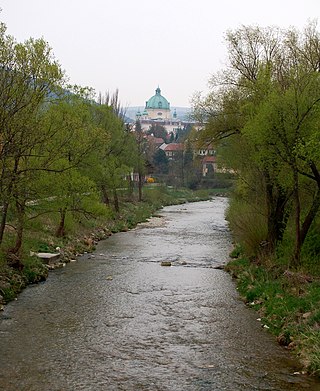
In the 18th century, metal-working companies such as Neuhirtenberger Kupferhammer, which used the first steam engine in all of Lower Austria in 1836, settled in this region. Before that, hydropower coming from the Triesting was the main energy source.

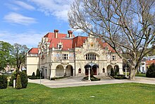
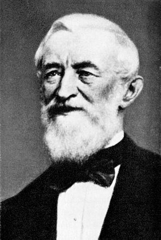
In the 19th century the majority of the inhabitants of Berndorf and its neighbouring villages worked in the metal industry. In 1844, Berndorf consisted of no more than 50 houses with about 180 inhabitants, when the cutlery factory of Alexander Schoeller and Hermann Krupp was founded. Initially, there were 50 workers, but throughout the years, the company developed and turned into a multi-national combine with over 6,000 employees. The development of the city of Berndorf was closely related to the history of the Krupp family. Arthur Krupp, son of Hermann Krupp, founded a private elementary school and a public swimming pool, as well as the neo-baroque St. Margaret's church.

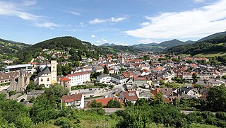
In 1923, the communities of Berndorf, St. Veit, Ödlitz and Veitsau were united and formed the city of Berndorf.

After the Anschluss in 1938, the Arthur Krupp company became a part of the German Krupp combine. Because of its industrial importance, Berndorf was also an important target of air attacks. During World War II, Berndorf was not even spared the forces of nature. The floods in 1939 and 1944 were the most destructive floods in the history of the Triesting river.

When the war had ended, the metal company was confiscated by the Soviet Army and incorporated into the USIA. In 1957, it was given back to the State of Austria and merged with the Vereinigte Aluminiumwerke Ranshofen (VAW).

Because of financial problems of the socialised industries in the 1980s, the Berndorf consortium was spun off and passed into private hands.

Population

Historical population
YearPop.±%
18693,331    
18804,172+25.2%
18906,776+62.4%
19009,117+34.5%
191012,788+40.3%
192312,604−1.4%
193410,949−13.1%
193910,959+0.1%
19519,541−12.9%
19618,992−5.8%
19718,690−3.4%
19818,690+0.0%
19918,264−4.9%
20018,642+4.6%
20118,763+1.4%

Culture

Theatre

The annual theatre festival takes place in the municipal theatre of Berndorf every summer.

Sights

Twin cities

Related Research Articles

Sankt Pölten City in Lower Austria, Austria

Sankt Pölten, mostly abbreviated to the official name St. Pölten, is the capital and largest city of the State of Lower Austria in northeast Austria, with 55,538 inhabitants as of 1 January 2020. St. Pölten is a city with its own statute and therefore it is both a municipality and a district in the Mostviertel.

Hernstein Place in Lower Austria, Austria

Hernstein is a town in Lower Austria, Austria in the district of Baden bei Wien.

Klosterneuburg Municipality in Lower Austria, Austria

Klosterneuburg is a town in Tulln District in the Austrian state of Lower Austria. It has a population of about 27,500. The Klosterneuburg Monastery, which was established in 1114 and soon after given to the Augustinians, is of particular historical importance.

Rohrau, Austria Place in Lower Austria, Austria

Rohrau is a village in the state of Lower Austria. The name comes from two German words: Rohr' 'reed' and Au 'riparian forest'. South of the village is a riparian forest and a swamp covered with reed.

Waidhofen an der Ybbs City in Lower Austria, Austria

Waidhofen an der Ybbs is an independent city (Statutarstadt) in the Austrian state of Lower Austria. The city had a population of 11,662 as of the 2001 census. It was first mentioned in 1186 and has been the economic centre of the Ybbstal valley since the 14th century.

Korneuburg Place in Lower Austria, Austria

Korneuburg is a town in Austria. It is located in the state Lower Austria and is the administrative center of the district of Korneuburg. Korneuburg is situated on the left bank of the Danube, opposite the city of Klosterneuburg, and is 12 km northwest of Vienna. It covers an area of 9.71 square km and, as of 2001, there were 11,032 inhabitants.

Straßburg, Austria Place in Carinthia, Austria

Straßburg is a town in the district of Sankt Veit an der Glan in Carinthia, Austria.

Hirtenberg Place in Lower Austria, Austria

Hirtenberg is a town of approx. 2,500 inhabitants near Baden bei Wien in Lower Austria, Austria. The river Triesting is located at the south border of the town. Coming from the Vienna Woods, the valley of Triesting joins the Vienna Basin here.

Baden District, Austria District in Lower Austria, Austria

Bezirk Baden is a district of the state of Lower Austria in Austria.

Mistelbach Place in Lower Austria, Austria

For the town in Germany, see Mistelbach, Bavaria.

Feldkirchen in Kärnten Place in Carinthia, Austria

Feldkirchen in Kärnten is a town in the Austrian state of Carinthia and the capital of the district of the same name. It consists of the Katastralgemeinden Fasching, Feldkirchen, Glanhofen, Gradisch, Hoefling, Klein Sankt Veit, Pernegg, Rabensdorf, Sankt Ulrich, Sittich, Tschwarzen and Waiern. The name Feldkirchen is meaning the church in the fields.

Sankt Veit an der Glan Place in Carinthia, Austria

Sankt Veit an der Glan is a town in the Austrian state of Carinthia, the administrative centre of the Sankt Veit an der Glan District. It was the historic Carinthian capital until 1518.

Althofen Place in Carinthia, Austria

Althofen is a town in the district of Sankt Veit an der Glan in the Austrian state of Carinthia.

Liebenfels Place in Carinthia, Austria

Liebenfels is a market town in the district of Sankt Veit an der Glan in the Austrian state of Carinthia.

Altenmarkt an der Triesting Place in Lower Austria, Austria

Altenmarkt an der Triesting is a town in the district of Baden in Lower Austria in Austria.

Pottenstein, Austria Place in Lower Austria, Austria

Pottenstein is a town in the district of Baden in Lower Austria in Austria.

Trumau Place in Lower Austria, Austria

Trumau is a town in the district of Baden in Lower Austria in Austria.

Sankt Veit an der Gölsen Place in Lower Austria, Austria

Sankt Veit an der Gölsen is a town in the district of Lilienfeld in the Austrian federal state of Lower Austria.

Brixlegg Place in Tyrol, Austria

Brixlegg is a market town in the Kufstein district in the Austrian state of Tyrol. The town lies in the Lower Inn Valley and at the entrance of the Alpbachtal.

Triesting

The Triesting is a river of Lower Austria, in the southeastern part of the Vienna Woods.

References

  1. "Dauersiedlungsraum der Gemeinden Politischen Bezirke und Bundesländer - Gebietsstand 1.1.2018". Statistics Austria. Retrieved 10 March 2019.
  2. "Einwohnerzahl 1.1.2018 nach Gemeinden mit Status, Gebietsstand 1.1.2018". Statistics Austria. Retrieved 9 March 2019.

Further reading