Klausen-Leopoldsdorf | |
|---|---|
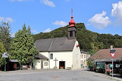 Klausen-Leopoldsdorf parish church | |
 Coat of arms | |
 Klausen-Leopoldsdorf Location within Austria | |
| Coordinates: 48°6′N16°0′E / 48.100°N 16.000°E | |
| Country | Austria |
| State | Lower Austria |
| District | Baden |
| Government | |
| • Mayor | Herbert Lameraner |
| Area | |
• Total | 60.04 km2 (23.18 sq mi) |
| Elevation | 375 m (1,230 ft) |
| Population (2018-01-01) [2] | |
• Total | 1,681 |
| • Density | 28/km2 (73/sq mi) |
| Time zone | UTC+1 (CET) |
| • Summer (DST) | UTC+2 (CEST) |
| Postal code | 2533 |
| Area code | 02257 |
| Website | www.klausen-leopoldsdorf.gv.at |
Klausen-Leopoldsdorf a town in the district of Baden in Lower Austria in Austria.