El Oued, Souf or Oued Souf is a city, and the capital of El Oued Province, in Algeria. The oasis town is watered by an underground river, hence its name is El Oued which enables date palm cultivation and the rare use of brick construction for housing. As most roofs are domed, it is known as the "City of a Thousand Domes".
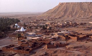
El Goléa is an oasis town and commune, and capital of El Ménia District, in Ghardaïa Province, Algeria. The official name is El Ménia ; together in Arabic, the two names mean Impregnable Castle. According to the 2008 census it has a population of 40,195, up from 28,848 in 1998, with an annual growth rate of 3.4%. The area is inhabited by the Zenete Berbers. El Goléa oasis grows many agricultural products. The grave of the French priest Charles de Foucauld is located in the town.
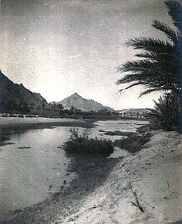
Oued Zouzfana is an intermittent river, or wadi, that flows through the Oriental region in southeastern Morocco and Béchar Province in southwestern Algeria.

Mazzer is a village in the commune of Igli, Algeria, in Béchar Province, Algeria. The village lies on the Oued Saoura south of Igli and north of Béni Abbès.
Tigdidine is a village in the commune of Djamaa, in El Oued Province, Algeria. The village is 4 kilometres (2.5 mi) east of Djamaa.
Baadj is a village in the commune of Oum Touyour, in El M'Ghair District, El Oued Province, Algeria. The village is located on the W31 regional road just northwest of where it meets the N3 highway, near Oum Touyour. 13 kilometres (8.1 mi) south of Djamaa.
Hobba is a village in the commune of Reguiba, in Reguiba District, El Oued Province, Algeria. The village is located on the N48 highway at the junction with a local road leading to Reguiba, 29 kilometres (18 mi) northwest of El Oued.
Souihla is a village in the commune of Sidi Aoun, in Magrane District, El Oued Province, Algeria. The village is located to the north-west of the N3 highway 18 kilometres (11 mi) northeast of El Oued.
Gottaï is a village in the commune of Magrane, El Oued Province, Algeria. It is located 28 kilometres (17 mi) north of the provincial capital El Oued.
Khobna is a village in the commune of Trifaoui, in Hassi Khelifa District, El Oued Province, Algeria. The village is located 2 kilometres (1.2 mi) southeast of Trifaoui and 10 kilometres (6.2 mi) northeast of the provincial capital El Oued.
Lizerg is a village in the commune of Trifaoui, in Hassi Khelifa District, El Oued Province, Algeria. The village is located 3.5 kilometres (2.2 mi) southeast of Trifaoui and 11 kilometres (6.8 mi) northeast of the provincial capital El Oued.
Sidi Slimane is a village in the commune of Bayadha, in Bayadha District, El Oued Province, Algeria. The village is located 6 kilometres (3.7 mi) southeast of the provincial capital El Oued.
Oum Sahaouine is a village in the commune of El Oued, in El Oued District, El Oued Province, Algeria. The village is located 8 kilometres (5.0 mi) southeast of El Oued city, and is accessible by a local road to the south of the N16 highway.
Chégamat is a village in the commune of Oued El Alenda, in Mih Ouensa District, El Oued Province, Algeria. The village is located 3 kilometres (1.9 mi) southeast of Oued El Alenda and 15 kilometres (9.3 mi) southwest of the provincial capital El Oued.
Débidibi is a village in the commune of Robbah, in Robbah District, El Oued Province, Algeria. The village is located 7 kilometres (4.3 mi) south of Robbah and 17 kilometres (11 mi) south of the provincial capital El Oued.
Dabadib is a village in the commune of Oued El Alenda, in Mih Ouensa District, El Oued Province, Algeria. The village is located 3 kilometres (1.9 mi) southeast of Oued El Alenda and 19 kilometres (12 mi) southwest of the provincial capital El Oued.
Oudeï Turk is a village in the commune of Mih Ouensa, in Mih Ouensa District, El Oued Province, Algeria. The village is located 7 kilometres (4.3 mi) northwest of Mih Ouensa and 22 kilometres (14 mi) southwest of the provincial capital El Oued.
Bougoufa is a village in the commune of Mih Ouensa, in Mih Ouensa District, El Oued Province, Algeria. The village is located 12 kilometres (7.5 mi) southeast of Mih Ouensa and 30 kilometres (19 mi) southwest of the provincial capital El Oued.
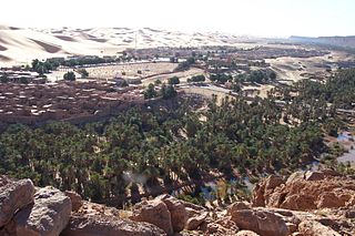
Zaouia Foukania is a village and zaouia in the commune of Taghit, in Taghit District, Béchar Province, Algeria. It is located 3 kilometres (1.9 mi) northwest of Taghit.