Tamtert, also written Tamert or Tamatart is a town and commune in Béni Abbès District, Béni Abbès Province, in western Algeria. According to the 2008 census its population is 1,248, down from 1,302 in 1998, with an annual growth rate of -0.4%. The commune covers an area of 3,130 square kilometres (1,210 sq mi).
Guerzim is a village in the commune of Béni Ikhlef, in Kerzaz District, Béchar Province, Algeria. The village lies on the Oued Saoura 10 kilometres (6.2 mi) north of Béni Ikhlef and 28 kilometres (17 mi) southeast of El Ouata.
El Beïda is a village in the commune of El Ouata, in Béchar Province, Algeria. The village lies on the Oued Saoura 28 kilometres (17 mi) north of Béni Ikhlef and 11 kilometres (6.8 mi) southeast of El Ouata.
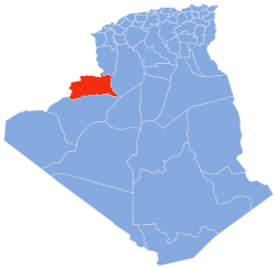
Béchir is a village in the commune of Tamtert, in El Ouata District, Béchar Province, Algeria. The village lies on the Oued Saoura 7 kilometres (4.3 mi) northwest of Tamtert and 29 kilometres (18 mi) southeast of Béni Abbès.
Zaouia el Kbira is a village in the commune of Kerzaz, in Béchar Province, Algeria. It lies on the Oued Saoura between Béni Ikhlef and Kerzaz. The village is on the N6 national highway, 8 kilometres (5.0 mi) northwest of Kerzaz and 15 kilometres (9.3 mi) southeast of Béni Ikhlef.
Hobba is a village in the commune of Reguiba, in Reguiba District, El Oued Province, Algeria. The village is located on the N48 highway at the junction with a local road leading to Reguiba, 29 kilometres (18 mi) northwest of El Oued.
Gottaï is a village in the commune of Magrane, El Oued Province, Algeria. It is located 28 kilometres (17 mi) north of the provincial capital El Oued.
Khobna is a village in the commune of Trifaoui, in Hassi Khelifa District, El Oued Province, Algeria. The village is located 2 kilometres (1.2 mi) southeast of Trifaoui and 10 kilometres (6.2 mi) northeast of the provincial capital El Oued.
Lizerg is a village in the commune of Trifaoui, in Hassi Khelifa District, El Oued Province, Algeria. The village is located 3.5 kilometres (2.2 mi) southeast of Trifaoui and 11 kilometres (6.8 mi) northeast of the provincial capital El Oued.
Sidi Slimane is a village in the commune of Bayadha, in Bayadha District, El Oued Province, Algeria. The village is located 6 kilometres (3.7 mi) southeast of the provincial capital El Oued.
Oum Sahaouine is a village in the commune of El Oued, in El Oued District, El Oued Province, Algeria. The village is located 8 kilometres (5.0 mi) southeast of El Oued city, and is accessible by a local road to the south of the N16 highway.
Chégamat is a village in the commune of Oued El Alenda, in Mih Ouensa District, El Oued Province, Algeria. The village is located 3 kilometres (1.9 mi) southeast of Oued El Alenda and 15 kilometres (9.3 mi) southwest of the provincial capital El Oued.
Débidibi is a village in the commune of Robbah, in Robbah District, El Oued Province, Algeria. The village is located 7 kilometres (4.3 mi) south of Robbah and 17 kilometres (11 mi) south of the provincial capital El Oued.
Dabadib is a village in the commune of Oued El Alenda, in Mih Ouensa District, El Oued Province, Algeria. The village is located 3 kilometres (1.9 mi) southeast of Oued El Alenda and 19 kilometres (12 mi) southwest of the provincial capital El Oued.
Oudeï Turk is a village in the commune of Mih Ouensa, in Mih Ouensa District, El Oued Province, Algeria. The village is located 7 kilometres (4.3 mi) northwest of Mih Ouensa and 22 kilometres (14 mi) southwest of the provincial capital El Oued.
El Kafaf is a village in the commune of Mih Ouensa, in Mih Ouensa District, El Oued Province, Algeria. The village is located on a local road that branches off to the northwest from the N16 highway, 4.5 kilometres (2.8 mi) southwest of Mih Ouensa and 27 kilometres (17 mi) southwest of the provincial capital El Oued.
Mih Lachache is a village in the commune of Mih Ouensa, in Mih Ouensa District, El Oued Province, Algeria. The village is located 17 kilometres (11 mi) west of Mih Ouensa and 35 kilometres (22 mi) southwest of the provincial capital El Oued.
Sahabane is a village in the commune of Mih Ouensa, in Mih Ouensa District, El Oued Province, Algeria. The village is located 4 kilometres (2.5 mi) southeast of Mih Ouensa and 24 kilometres (15 mi) southwest of the provincial capital El Oued.

Mih Moulahoum is a village in the commune of Mih Ouensa, in Mih Ouensa District, El Oued Province, Algeria. The village is located 8 kilometres (5.0 mi) south of Mih Ouensa and 30 kilometres (19 mi) southwest of the provincial capital El Oued.
Bougoufa is a village in the commune of Mih Ouensa, in Mih Ouensa District, El Oued Province, Algeria. The village is located 12 kilometres (7.5 mi) southeast of Mih Ouensa and 30 kilometres (19 mi) southwest of the provincial capital El Oued.