The Libyan Desert is a geographical region filling the northeastern Sahara Desert, from eastern Libya to the Western Desert of Egypt and far northwestern Sudan. On medieval maps, its use predates today's Sahara, and parts of the Libyan Desert include the Sahara's most arid and least populated regions; this is chiefly what sets the Libyan Desert apart from the greater Sahara. The consequent absence of grazing, and near absence of waterholes or wells needed to sustain camel caravans, prevented Trans-Saharan trade between Kharga close to the Nile, and Murzuk in the Libyan Fezzan. This obscurity saw the region overlooked by early European explorers, and it was not until the early 20th century and the advent of the motor car before the Libyan Desert started to be fully explored.

László Adolf Ede György Mária Almásy de Zsadány et Törökszentmiklós was a Hungarian aristocrat, motorist, desert explorer, aviator, Scout-leader, and sportsman who served as the basis for the protagonist in both Michael Ondaatje's novel The English Patient (1992) and the movie adaptation of the same name (1996).
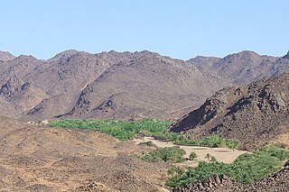
The Aïr Mountains or Aïr Massif is a triangular massif, located in northern Niger, within the Sahara. Part of the West Saharan montane xeric woodlands ecoregion, they rise to more than 1,800 m (5,900 ft) and extend over 84,000 km2 (32,000 sq mi). Lying in the midst of desert north of the 17th parallel, the Aïr plateau, with an average altitude between 500 and 900 m, forms an island of Sahel climate which supports a wide variety of life, many pastoral and farming communities, and dramatic geological and archaeological sites. There are notable archaeological excavations in the region that illustrate the prehistoric past of this region. The endangered African wild dog once existed in this region, but may now be extirpated due to human population pressures in this region.

In archaeology, rock arts are human-made markings placed on natural surfaces, typically vertical stone surfaces. A high proportion of surviving historic and prehistoric rock art is found in caves or partly enclosed rock shelters; this type also may be called cave art or parietal art. A global phenomenon, rock art is found in many culturally diverse regions of the world. It has been produced in many contexts throughout human history. In terms of technique, the four main groups are:

Gilf Kebir is a plateau in the New Valley Governorate of the remote southwest corner of Egypt, and southeast Libya. Its name translates as "the Great Barrier". This 7,770 km2 (3,000 sq mi) sandstone plateau, roughly the size of Puerto Rico, rises 300 m (980 ft) from the Libyan Desert floor. It is the true heart of the Gilf Kebir National Park.

Saharan rock art is a significant area of archaeological study focusing on artwork carved or painted on the natural rocks of the central Sahara desert. The rock art dates from numerous periods starting c. 12,000 years ago, and is significant because it shows the culture of ancient African societies.

The Eastern Desert is the part of the Sahara Desert that is located east of the Nile River. It spans 223,000 square kilometres (86,000 sq mi) of northeastern Africa and is bordered by the Gulf of Suez and the Red Sea to the east, and the Nile River to the west. It extends through Egypt, Eritrea, Ethiopia, and the Sudan. The Eastern Desert consists of a mountain range which runs parallel to the coast, wide sedimentary plateaus extending from either side of the mountains and the Red Sea coast. The rainfall, climate, vegetation and animal life sustained in the desert varies between these different regions. The Eastern Desert has been a mining site for building materials, as well as precious and semi-precious metals, throughout history. It has historically contained many trade routes leading to and from the Red Sea, including the Suez Canal.
Uan Muhuggiag is an archaeological site in Libya that was occupied by pastoralists between the early Holocene and mid-Holocene; the Tashwinat mummy, which was found at Uan Muhuggiag, was dated to 5600 BP and presently resides in the Assaraya Alhamra Museum in Tripoli.

The Acacus Mountains or Tadrart Akakus form a mountain range in the desert of the Ghat District in western Libya, part of the Sahara. They are situated east of the city of Ghat, Libya, and stretch north from the border with Algeria, about 100 kilometres (62 mi). The area has a particularly rich array of prehistoric rock art.

Kebira Crater is the name given to a circular topographic feature that was identified in 2007 by Farouk El-Baz and Eman Ghoneim using satellite imagery, Radarsat-1, and Shuttle Radar Topography Mission (SRTM) data in the Sahara desert. This feature straddles the border between Egypt and Libya. The name of this feature is derived from the Arabic word for "large", and also from its location near the Gilf Kebir region in southwest Egypt. Based solely on their interpretations of the remote sensing data, they argue that this feature is an exceptionally large, double-ringed, extraterrestrial impact crater. They suggest that the crater's original appearance has been obscured by wind and water erosion over time. Finally, they speculated that this feature might be the source of the yellow-green silica glass fragments, known as "Libyan desert glass", that can be found across part of Egypt's Libyan Desert. They neither conducted any fieldwork at this feature nor studied any samples collected from it. However, the Kebira Crater is currently not listed in the Earth Impact Database. Field trips to investigate the feature have found no supporting evidence. The "central uplift" clearly retains the horizontal bedding of the surrounding sandstone tableland, providing clear evidence against a possible impact origin.

Mount Uwaynat or Gabal El Uweinat is a mountain range in the area of the Egyptian-Libyan-Sudanese tripoint. Because of thousands of prehistoric rock art sites, it is considered an important witness to the development of early pastoralism in the Sahara.

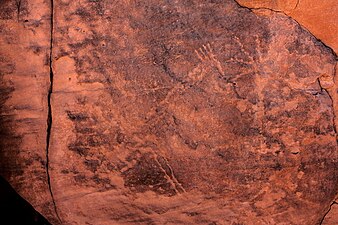
The Cave of Swimmers is a cave with ancient rock art in the mountainous Gilf Kebir plateau of the Libyan Desert section of the Sahara. It is located in the New Valley Governorate of southwest Egypt, near the border with Libya.

Mount Arkanu or Jabal Arkanu is a mountain in Libya.

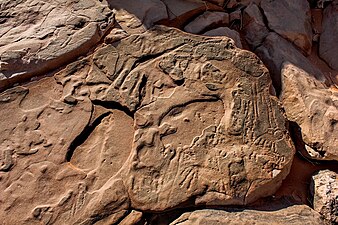
The Cave of the Beasts is a huge natural rock shelter in the Western Desert of Egypt featuring Neolithic rock paintings, more than 7,000 years old, with about 5,000 figures.

Alberto Siliotti is a scientific journalist, writer and photographer. For more than 20 years, he studied history, archeology and the natural environment of Egypt, where he started to work in 1988 as the director of the Horus mission, led by the Italian ministry of foreign affairs who wanted to relate the itineraries of the Italian travelers of the 19th century – especially Giovanni Battista Belzoni who discovered the entry of Chepren pyramid and Sethi I tomb in the king valley. He has made for the British Museum, a scholarly edition of Belzoni's travels, among plenty of objects recovered in Egypt are part of the museum collections.

The Sabu-Jaddi rock art site in Sudan is a unique cluster of more than 1600 rock drawings from different historical periods expanding for more than 6000 years through different eras of Nubian civilization. however, exactly when the people living in this region began creating these images is still unknown. The site is located 600 km north of Khartoum between the villages of Sabu and Jaddi. The well-preserved drawings include wild and domestic animals, humans and boats.
In Egypt, the Western Desert is an area of the Sahara that lies west of the river Nile, up to the Libyan border, and south from the Mediterranean Sea to the border with Sudan. It is named in contrast to the Eastern Desert which extends east from the Nile to the Red Sea. The Western Desert is mostly rocky desert, though an area of sandy desert, known as the Great Sand Sea, lies to the west against the Libyan border. The desert covers an area of 680,650 km2 (262,800 sq mi) which is two-thirds of the land area of the country. Its highest elevation is 1,000 m (3,300 ft) in the Gilf Kebir plateau to the far south-west of the country, on the Egypt-Sudan-Libya border. The Western Desert is barren and uninhabited save for a chain of oases which extend in an arc from Siwa, in the north-west, to Kharga in the south. It has been the scene of conflict in modern times, particularly during the Second World War.
Gilf Kebir National Park (GKNP) is a national park located in the remote and hyper-arid New Valley Governorate, Egypt. Established in 2007, it has a surface area of 48533 km2, equal to about 5% of Egypt's territory. GKNP is delimited to the west by Libya and to the south by Sudan. At present there are no human settlements or facilities inside the GKNP.

Magharet el Kantara or Shaw's Cave is a rock art shelter of the Gilf Kebir National Park in the New Valley Governorate, Egypt. Located on the south-western slopes of Gilf Kebir, it was discovered in 1935 by the explorers Bill Kennedy Shaw and Rupert Harding Newman.
Elisabeth Charlotte Pauli was an artist and ethnographer working at the Frobenius Institute in Frankfurt am Main. She participated in several expeditions of the institute as participant and co-organiser, and produced a large number of copies of prehistoric rock art in Europe and Africa. During the Second World War she and three other women acted as the temporary management of the institute.