The Coral Sea Islands Territory is an external territory of Australia which comprises a group of small and mostly uninhabited tropical islands and reefs in the Coral Sea, northeast of Queensland, Australia. The only inhabited island is Willis Island. The territory covers 780,000 km2 (301,160 sq mi), most of which is ocean, extending east and south from the outer edge of the Great Barrier Reef and includes Heralds Beacon Island, Osprey Reef, the Willis Group and fifteen other reef/island groups. Cato Island is the highest point in the Territory.

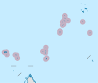
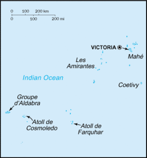
Seychelles is a small island country located in the Somali sea northeast of Madagascar and about 835 mi (1,344 km) from Mogadishu, Somalia, its nearest foreign mainland city, while Antsiranana is the nearest foreign city overall. Seychelles lies between approximately 4ºS and 10ºS and 46ºE and 54ºE. The nation is an archipelago of 115 tropical islands, some granite and some coral. the majority of which are small and uninhabited. The landmass is only 452 km2 (175 sq mi), but the islands are spread wide over an exclusive economic zone of 1,336,559 km2 (516,048 sq mi). About 90 percent of the population of 90,000 live on Mahé, 9 percent on Praslin and La Digue. Around a third of the land area is the island of Mahé and a further third the atoll of Aldabra.
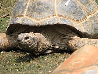
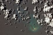
Aldabra is the world's second-largest coral atoll. It is situated in the Aldabra Group of islands in the Indian Ocean that are part of the Outer Islands of the Seychelles, with a distance of 1,120 km (700 mi) southwest of the capital, Victoria, on Mahé Island.
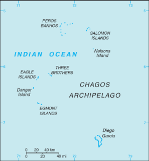
The British Indian Ocean Territory (BIOT) is an archipelago of 55 islands in the Indian Ocean, located south of India. It is situated approximately halfway between Africa and Indonesia. The islands form a semicircular group with an open sea towards the east. The largest, Diego Garcia, is located at the southern extreme end. It measures 60 square kilometres (23 sq mi) and accounts for almost three-quarters of the total land area of the territory. Diego Garcia is the only inhabited island and is home to the joint UK-US naval support facility. Other islands within the archipelago include Danger Island, Three Brothers Islands, Nelson Island, and Peros Banhos, as well as the island groups of the Egmont Islands, Eagle Islands, and the Salomon Islands.
Cosmoledo Atoll is an atoll of the Aldabra Group and belongs to the Outer Islands of the Seychelles, and is located 1,029 km (639 mi) southwest of the capital, Victoria, on Mahé Island.

The Amirante Islands are a group of coral islands and atolls that belong to the Outer Islands of the Seychelles.
The Farquhar Atoll is part of the Farquhar Group of islands in the Seychelles that are part of the Outer Islands. It is located 770 kilometres southwest of the capital, Victoria, on Mahé Island.
Alphonse Atoll is one of two atolls of the Alphonse Group, the other being St. François Atoll — both in the Outer Islands coral archipelago of the Seychelles.
Platte Island or Île Platte is an island in the Southern Coral Group that is part of the Outer Islands of the Seychelles.
The Providence Atoll is part of the Farquhar Group of islands in the Seychelles that are part of the Outer Islands, with a distance of 705 km (438 mi) southwest of the capital, Victoria, on Mahé Island.
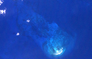
Astove Atoll is a large atoll, part of the Aldabra Group, lying in the Outer Islands of Seychelles, with a distance of 1,041 km (647 mi) southwest of the capital, Victoria, on Mahé Island.
Desroches Island or Île Desroches is the main island of the Amirante Islands, part of the Outer Islands of the Seychelles.
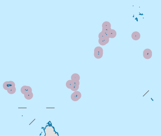
The Outer Islands or Coralline Seychelles (archipelago) is a collective term for those islands of the Seychelles that are not on the shallow Seychelles Bank which defines the location of the granitic Inner Islands archipelago to the east. The local Seychellois Creole name for the outer islands is Zil Elwannyen Sesel, while the French name is Îles Eloignées. They are all of coral formation, and in the western Indian Ocean.
St. Pierre Island is a raised reef island west of Providence Atoll and part of Farquhar Group, which belongs to the Outer Islands of the Seychelles. It has a distance of 736 km (457 mi) southwest of the capital, Victoria, on Mahé Island.
St. François Atoll is one of two atolls of the Alphonse Group in the Seychelles that are part of the Outer Islands.
The Alphonse Group belong to the Outer Islands of the Seychelles, lying in the southwest of the island nation, 403 kilometres southwest the capital, Victoria, on Mahé Island. The closest island is Desnœufs Island of the Amirante Islands, 87 km (54 mi) further north.

D'Arros Island is part of the Amirante Islands group, which are in the Outer Islands coral archipelago of the Seychelles islands and nation. The island is located west of the granitic Inner Seychelles archipelago, with a distance of 255 km south of Victoria, Seychelles.
Wizard Reef is a coral reef in the Farquhar Group in the Outer Islands of the Seychelles. It is 670 km (420 mi) southwest of the capital, Victoria, on Mahé Island.
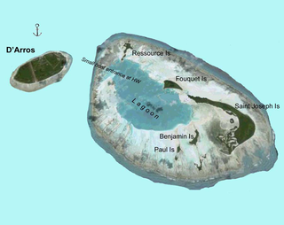
Saint Joseph Atoll is part of the Amirante Islands group, which are in the Outer Islands coral archipelago of the Seychelles islands and nation. The atoll is located southwest of the granitic Inner Seychelles archipelago, with a distance of 248 km south of Victoria, Seychelles.
Poivre Islands are a group of islands in Seychelles, lying in the Outer Islands of Seychelles, with a distance of 268 km south of Victoria, Seychelles.