Amirante Islands

Last updated
Amirante Islands
Nickname: Ilhas do Almirante
Amirantes-Sat.png
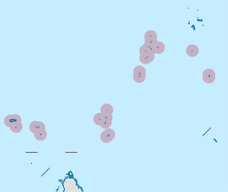
Satellite Image Map, with neighbouring Alphonse Group in the lower left
Seychelles location map.svg
Red pog.svg
Amirante Islands
Location of Amirante Islands in Seychelles
Geography
Location Indian Ocean
Coordinates 04°49′S53°40′E / 4.817°S 53.667°E / -4.817; 53.667
Archipelago Seychelles
Adjacent to Indian Ocean
Total islands20
Major islands
Area11.5 km2 (4.4 sq mi)
Highest elevation15 m (49 ft)
Administration
Group Outer Islands
Sub-Group Amirante Islands
Districts Outer Islands District
Largest settlement Île Desroches (pop. 40)
Demographics
Population300 (2014)
Pop. density26/km2 (67/sq mi)
Ethnic groups Creole, French, East Africans, Indians.
Additional information
Time zone
ISO code SC-26
Official website www.seychelles.travel/en/discover/the-islands/outer-islands

The Amirante Islands (Les Amirantes) are a group of coral islands and atolls that belong to the Outer Islands of the Seychelles.

Contents

They stretch about 155 km from the African Banks (African Islands) in the north to Desnœufs (Isle des Noeufs) in the south, all on the shallow Amirantes Bank (Amirantes Plateau, with depths of mostly 25 to 70 m), except the main island Île Desroches in the east, and submerged Lady Denison-Pender Shoal at the northern end. 90 km south of the Amirante Islands is Alphonse Group, the closest group of islands, which are sometimes considered part of the Amirantes.

History

The Amirantes were discovered by Vasco da Gama on his second voyage of exploration in 1503, and later named "Ilhas do Almirante" (Admiral Islands). Previous knowledge of the islands by Arab and Indian traders is possible. The islands were claimed by Sieur Michel Blin for France in 1802. By the Treaty of Paris (1814), the islands were passed officially to the British, as a part of Mauritius. In 1909, the Seychelles became a separate colony, thereby including the Amirantes. On 8 November 1965 the United Kingdom split Île Desroches from the Seychelles to become part of the newly created British Indian Ocean Territory. The purpose was to allow the construction of a military base for the mutual benefit of the United Kingdom and the United States. On 23 June 1976 Île Desroches was returned to the Seychelles as a result of the latter attaining independence.

The total land area is 11.5 km2. The total population is 300. The biggest concentrations are the Prison 2 km from Marie Louise village and the Collins group construction camp which is 2 km from the capital village of Desroches village (which had a population of 35 in the last census).

Islands

There are eight single islands (five low sand cays and three uplifted sand cays), plus three atolls with a total of 18 islets (St. Joseph Atoll with 14, Desroches with 1, Poivre Atoll with 3). In addition to these 11 units, the following table also has entries for a reef and a shoal without islets, for the sake of completeness. The five largest ones in area are inhabited. The different island types are marked by different background colours in the table.

 Island/Atoll/Reef
(alternate name)
typeArea
(km2)
Pop.
est.
Location
1 Lady Denison-Pender submerged shoal-- 04°49′S53°20′E / 4.817°S 53.333°E / -4.817; 53.333 (Lady Denison-Pender Shoal)
2 African Banks (African Islands)sand cay0.04- 04°53′S53°24′E / 4.883°S 53.400°E / -4.883; 53.400 (African Banks)
3 Remire Reef drying reef-- 05°05′S53°21′E / 5.083°S 53.350°E / -5.083; 53.350 (Remire Reef)
4 Remire (Eagle)uplifted sand cay0.276 05°07′S53°19′E / 5.117°S 53.317°E / -5.117; 53.317 (Remire Island)
5 D'Arros sand cay1.7142 05°24.5′S53°18′E / 5.4083°S 53.300°E / -5.4083; 53.300 (D'Arros Island)
6 St. Joseph atoll1.630 05°25′S53°20′E / 5.417°S 53.333°E / -5.417; 53.333 (Saint Joseph Atoll)
7 Bertaut sand cay0.002- 05°39′06″S53°14′18″E / 5.65167°S 53.23833°E / -5.65167; 53.23833 (Bertaut Reef)
8 Desroches atoll4.02100 05°41′S53°41′E / 5.683°S 53.683°E / -5.683; 53.683 (Île Desroches)
9 Poivre atoll2.7810 05°46′S53°19′E / 5.767°S 53.317°E / -5.767; 53.317 (Poivre Islands)
10 Étoile sand cay0.05- 05°53′S53°01′E / 5.883°S 53.017°E / -5.883; 53.017 (Étoile Cay)
11 Boudeuse sand cay0.03- 06°05′31″S52°49′50″E / 6.09194°S 52.83056°E / -6.09194; 52.83056 (Boudeuse Cay)
12 Marie Louise uplifted sand cay0.556150 06°11′S53°08′E / 6.183°S 53.133°E / -6.183; 53.133 (Marie Louise Island)
13 Desnœufs (Île des Noeufs)uplifted sand cay0.45- 06°14′S53°03′E / 6.233°S 53.050°E / -6.233; 53.050 (Île Desnœufs)
 Amirante Islandsisland chain11.530004°49' to 06°14'S,
52°50° to 53°41'E

Alphonse Group

90 km south of the Amirante Islands is Alphonse Group, the closest group of islands, which are sometimes considered part of the Amirantes chain because they are a southern continuation or extension of the Amirantes chain. Alphonse Group lies south of the Amirantes Bank, separated from it by deep water (generally 1000 to 2000 metres deep).

See also

References