- Île aux Cendres
- Îlot Parc
- Champignon des Os
- Grand Mentor
- Grand ÎIot
- Heron Rock
- Hide Island
- Île aux Aigrettes
- Île aux Cèdres
- Îles Chalands
- Île Fangame
- Île Héron
- Île Suacco
- Îlot Déder
- Îlot du Sud
- Îlot du Milieu
- Îlot du Nord
- Îlot Macoa
- Îlot Salade
- Middle Row Island
- Nobby Rock
- North Row Island
- Petit Mentor
- Petits ÎIots
- Pink Rock
- South Row Island
- Table Ronde
Geology
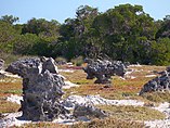
The atoll reflects both fossil and geomorphological features, the former is the source of the biodiversity seen today. [25] The atoll consists of reef limestone of Pleistocene age (with irregular coral formations called "champignon", [26] made up of two layers of varying stages of crystallization [27] ) and this extends over an average width of 2 kilometres (1.2 mi) rising to a height of 8 metres (26 ft) above sea level, and forming the rim line (low cliffs with "deep notches, preceded by jagged pinnacles") of the shallow central lagoon. [17] [11] [25] [21] Geologically the limestone beds have been subjected to striation, sink holes and pits with prominent and continuous limestone bed on the eastern side above the sediment deposits.
The coastline has undercut limestone cliffs above a perched beach; it is in two clear terraces of 8 metres (26 ft) and 6 metres (20 ft) height above sea level. [7] [27] While the terrestrial topography (spread over an elevation range of 0–8 metres (0–26 ft) [26] ) is rugged and dictated by the geomorphic conditions, the land surface comprises limestone of about 125,000 years age, which has uplifted many times above the sea level. The surface conditions are criss-crossed and riddled with pot holes and pits. In the eastern zone of the lagoon, though the surface is continuous, sediment beds are also seen. The windward southern coast is made up of sand dunes. [7]
Climate and tides
Aldabra is situated in the dry zone of the south-west Indian Ocean. The northwest monsoon season is from November to March and brings the heaviest rainfall. In the remaining months, the south-easterly trade winds are dominant. Aldabra receives an annual average rainfall of 960 millimetres (38 in). [21] Cyclones are rare in the Seychelles due to its nearness to the Equator. [28] The reported monthly mean maximum air temperature recorded in December is 31 °C (88 °F). The mean minimum temperature recorded in August is 22 °C (72 °F).
The hydrodynamics of Aldabra's lagoon are dominated by the tides. The maximum tidal range at Aldabra is around 2.7m, which is exceptionally large for an atoll. Flow between the lagoon and open ocean is only possible through a small number of narrow channels, generating tidal currents of over 3 m/s at Passe Gionnet, and over 1 m/s at most other channels. Due to the restriction of water exchange through these channels, tides within the lagoon are lagged compared to the open ocean, and the tidal range varies across the lagoon. [29]
Aldabra sits in the path of the Indian Ocean's westward-flowing South Equatorial Current. Eddies are generated in the wake of Aldabra as the South Equatorial Current passes it, driving upwelling of deep waters that bring nutrients to the surface, and drive phytoplankton growth. [30]
Wildlife

The earliest study of the flora and fauna, and also the geomorphological structure was in 1910. There are 307 species of animals and plants on Aldabra. [31] Reptiles are the prominent terrestrial fauna. [7] Sir David Attenborough called Aldabra "One of the wonders of the world", and it is also known as one of "crown jewels" of the Indian Ocean. [32] [33]
Flora
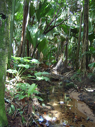
The higher areas of Aldabra are covered in pemphis , a thick coastal shrub, while the lower areas, home to the giant tortoises, are a mixture of trees, shrubs, herbs and grasses. There have been recorded 273 species of flowering plants, shrubs, and ferns on the atoll. There are dense thickets of Pemphis acidula , and a mixture of grasses and herbs called "tortoise turf" in many areas. [7] [26] This flora includes 19 endemic species and 22 species that are only common to neighboring islands, and several of these species are on the IUCN Red List. The tropicbird orchid ( Angraecum seychellarum ) is the national flower of Seychelles and is found in the dry craggy limestone champignon of Aldabra. [34] Other endemic plants includes Pandanus aldabrensis , the Aldabra lily ( Aloe aldabrensis ) and a sub-species of tropicbird orchid, Angraecum eburneum. [35]
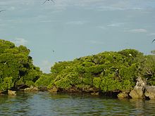
The lagoon is bordered by mangrove forests, and has large inland seagrass meadows as well as areas of coral reef and sand flats. [7] The mangroves, which thrive in tidal mudflat areas and saline conditions, are seen on the shores of the lagoon and are integral to the coastal ecosystem. There are seven species of mangrove on Aldabra, three of which are rarely occurring species. These include 'Mangliye blan' or white mangrove ( Avicennia marina ) which grows to 12 metres (39 ft), 'Mangliye lat' or black mangrove (Bruguiera gymnorhiza) which grows to 18 metres (59 ft) in a conical shape, 'Mangliye zonn' (Ceriops tagal) which grows to 7 metres (23 ft) with a buttressed trunk, and 'Mangliye rouz' or red mangrove ( Rhizophora mucronata ) which is the tallest species up to 20 metres (66 ft) in height. [36]
Fauna


The atoll has distinctive fauna including the largest population of giant tortoises (Aldabrachelys gigantea) in the world (100,000 animals). [37] [38] Tortoise size varies substantially across the atoll, but adult tortoises typically have a carapace length of 105 centimetres (41 in) and can weigh up to 350 kilograms (770 lb). They are herbivores and feed on plants, trees and algae that grows in the freshwater pools. The tortoises mate between February and May, the females then lay their eggs from June to September in areas with suitable soil layers. They lay eggs the size of golf balls [12] in a clutch of three to five eggs every few years in high-density areas and 14-16 eggs in low-density areas. The females can lay several clutches in a year and [39] the incubation period is 73–160 days. The small vulnerable juveniles are prey to coconut crabs, land crabs, rats and birds. [12] In the past giant tortoises have been relocated to other islands in Seychelles and also to Victoria Botanical Gardens in Mahé. [12] One of the longest-lived Aldabra giant tortoises was Adwaita, a male who died at the age of about 250 years at Kolkata's Alipore Zoological Gardens on 24 March 2006.

Aldabra is a breeding ground for the hawksbill sea turtle (Eretmochelys imbricata) and green sea turtle (Chelonia mydas). [33] Aldabra has one of the largest populations of nesting green turtles in the Western Indian Ocean. Aldabra has a large population of the world's largest terrestrial arthropod, the coconut crab (Birgus latro); and hosts the white-throated rail, the only surviving flightless rail species in the Indian Ocean. [2] Sharks, manta rays, and barracuda populate the seas surrounding the island. During the Pleistocene the dominant land predator was the crocodilian Aldabrachampsus which is now extinct. Three extant species of lizards occur, the skink Cryptoblepharus boutonii and the geckos Phelsuma abbotti and Hemidactylus mercatorius. Pleistocene fossils also indicate the former presence of an Oplurus iguana and other skink and gecko species. [40] There are three endemic species of bat from Aldabra: Paratriaenops pauliani , [41] Chaerephon pusilla and the Aldabra flying fox (Pteropus aldabrensis), as well as the more widely distributed Mauritian tomb bat (Taphozous mauritianus). [42] There are 1,000 species of insects, many of them endemic. [7] Many species of butterflies also flutter around Aldabra. [43]
Endemic birds include the Aldabra drongo (Dicrurus aldabranus), the Aldabran subspecies of the white-throated rail (Dryolimnas cuvieri aldabranus), the last surviving flightless bird of the Indian Ocean region, and the endemic Aldabra fody (Foudia aldabrana), [26] The islands are important breeding grounds for thousands of seabirds, including several species of tern, red-tailed tropicbirds, white-tailed tropicbirds, red-footed boobies, and the world's second largest breeding populations of great and lesser frigate birds. [7] [33] [44] The bird fauna is most similar to Madagascar or Comoros and other birds found here include greater flamingos, the Malagasy pond heron, Comoros blue pigeon, Malagasy kestrel, Malagasy coucal, Madagascar nightjar, Malagasy bulbul and souimanga sunbird. [45] [46] [47] [48]
At least 13 species of cetaceans, including dolphins, orcas, and especially humpback whales, [49] [50] have been identified in the waters. [51] [52] Dugongs, thought to be regionally extinct in the 18th century, [53] have been confirmed multiple times in recent years. [54] [55] [56]
Conservation
Conservationists feared a major threat to the atoll's biodiversity in the 1960s when, as part of the British Indian Ocean Territory, the British made plans to set up a military establishment on the atoll. Due to national and international opposition this plan was cancelled in 1967. This incident became known as the 'Aldabra Affair' in England.
Invasive alien species such as rats, cats and goats that were introduced in the past threaten the native biodiversity of the atoll. Goats were eradicated from the atoll in 2012 after a long-term eradication program. Cats have been removed from all of the islands except Grande Terre Island, which allowed for the reintroduction of the Aldabra rail to Picard Island. Research into a feasibility study to eradicate rats from the atoll has been undertaken.
Until recently, Aldabra had remained free of invasive birds. However, the Madagascar fody ( Foudia madagascariensis ) has spread to Aldabra after being introduced to Assumption Island. An eradication program for this bird on both Assumption and Aldabra is almost complete. Due to the limited space of its habitat, extreme weather conditions, epidemic and limited range could also pose serious threats to the entire ecology of the atoll. [39]
Aldabra also accumulates large amounts of plastic pollution on its coastline and, despite a major clean-up effort in 2019, over 500 tonnes is thought to remain on the atoll, with significant impacts on wildlife. [57] Most of this pollution originates from the regional fishing industry, although a significant proportion is also transported from southeast Asia through ocean currents. [58]
The coral reefs at Aldabra were severely affected by the 2016 El Niño event. Although thermal stress was not exceptionally high (less than 4 Degree Heating Weeks), hard coral cover on Aldabra's seaward-facing reefs was reduced by over 50% (35% in the lagoon), and soft coral cover fell by over 90%. [59] Fortunately, there are some signs of recovery, as the abundance of juvenile corals has since increased significantly, particularly within the lagoon, [60] although Aldabra's reefs of course remain critically threatened by climate change.
Protection
Aldabra atoll was designated a UNESCO World Heritage Site on 19 November 1982. It is one of the two UNESCO World Heritage Sites in the Seychelles;, [61] and is managed by the Seychelles Islands Foundation (SIF). [62] The marine protected area extends 1 kilometre (0.62 mi) into the sea to ensure preservation of its marine fauna. [7] [26] Eco tourism is controlled and introduction of invasive species is restricted. [7]
Based on the evaluation process, UNESCO inscribed the site, a legally protected special reserve of 35,000 hectares (86,000 acres), on the list of World Heritage Sites under three criteria: Criterion (vii): Aldabra Atoll encompasses a large expanse of relatively untouched natural beauty where a number of important animal species and some plant species thrive, along with remarkable land formations, and its process provides a unique spectacle of natural phenomena; [7] Criterion (ix): The atoll is a superlative example of an oceanic island ecosystem in which evolutionary processes are active within a rich biota. The size and morphological diversity of the atoll has permitted the development of a variety of discrete insular communities with a high incidence of endemicity among the constituent species that are typical of island ecosystems. The natural processes take place with minimal human interference and can be clearly demonstrated in their full complexity; [7] and Criterion (x): Aldabra provides a natural laboratory for the study of the process of evolutionary ecology and is a platform for key scientific discovery. The atoll constitutes a refuge harboring viable populations of a range of rare and endangered species of plants and animals, including the last giant tortoise and flightless bird populations of the Western Indian Ocean, a substantial marine turtle breeding population, and large seabird colonies which number in the tens of thousands. The substantial tortoise population is self-sustaining and all the elements of its inter-relationship with the terrestrial environment are evident. [7] [63]
BirdLife International declared Aldabra as an Important Endemic Bird Area (IBA) in 2001 due to its large seabird colonies under categories A1, A2, A4i, A4ii and A4iii, covering an area of 33,180 hectares (82,000 acres) overlapping with the special reserve area of 35,000 hectares (86,000 acres) of Aldabra Atoll. [26] [64]
Aldabra became a Ramsar Convention Wetland Site of International Importance in 2010. [17] Covering 25,100 ha (over half the area of the whole atoll) the wetland ecosystem of Aldabra includes the extensive shallow lagoon inside the atoll, which is carpeted with lush seagrass beds and patchy coral reefs, the intertidal mud flats, the coral reefs outside the lagoon, freshwater pools, beaches, and 2000 ha of mangrove stands. These wetlands support several endangered species including the increasing number of turtles at the atoll, dugongs and many other bird, fish and invertebrate species.
Aldabra was designated as a site under the Indian Ocean South East Asia (IOSEA) turtle network, in their 2014 convention.
Demography
A small scientific research station of the SIF is based in La Gigi village on Picard Island. The permanent staff (currently 12 [65] ) conduct research to study Aldabra's biodiversity.
Transport
Aldabra is not easily accessed. No airstrips, helipads or landing jetties have been permitted on the atoll. The nearest airfield is on Assumption is 50 kilometres (31 mi) south-east of Picard Island. Bi-monthly supply ships operating from Mahé provide essentials to the research station. [11]
Tourism
Cruises are operated by several companies [66] [67] along with dive boats which may visit the atoll on expedition tours. Visits to the island by people other than the scientists and staff of the SIF are strictly controlled and only guided tours are provided with prior permission. [66] As of 2012 [update] , a yearly average of 900 tourists visit the atoll. Within the atoll, paved walking paths exist from the village of La Gigi, which leads to a promontory from where scenic views of the large lagoon (during low tides) and the mangrove species are seen. [66]
Related Research Articles

Europa Island, in Malagasy Nosy Ampela is a 28-square-kilometre (11 sq mi) low-lying tropical atoll in the Mozambique Channel, about a third of the way from southern Madagascar to southern Mozambique. The island had never been inhabited until 1820, when the French family of Rosier moved to it. The island officially became a possession of France in 1897, though it is claimed by Madagascar.
The Glorieuses or Glorioso Islands are a group of islands and rocks totaling 5 square kilometres (1.9 sq mi). They are controlled by France as part of the Scattered Islands in the Indian Ocean in the French Southern and Antarctic Lands, a French overseas territory, but are also claimed by Comoros, Madagascar and formerly by Seychelles. They are geographically part of the Comoro Islands between the French overseas region of Mayotte and the nation of Madagascar.
Seychelles, officially the Republic of Seychelles, is an island country and archipelagic state consisting of 155 islands in the Indian Ocean. Its capital and largest city, Victoria, is 1,500 kilometres east of mainland Africa. Nearby island countries and territories include the Comoros, Madagascar, Mauritius, and the French overseas departments of Mayotte and Réunion to the south; and the Chagos Archipelago to the east. Seychelles is the smallest country in Africa as well as the least populated sovereign African country, with an estimated population of 100,600 in 2022.

Seychelles is a small island country east of the African continent located in the Sea of Zanj due north of Madagascar, with Antsiranana as its nearest foreign city. Seychelles lies between approximately 4ºS and 10ºS and 46ºE and 54ºE. The nation is an archipelago of 155 tropical islands, some granite and some coral, the majority of which are small and uninhabited. The landmass is only 452 km2 (175 sq mi) but the islands are spread wide over an exclusive economic zone of 1,336,559 km2 (516,048 sq mi). About 90 percent of the population of 100,000 live on Mahé, 9 percent on Praslin and La Digue. Around a third of the land area is the island of Mahé and a further third the atoll of Aldabra.

The Aldabra giant tortoise is a species of tortoise in the family Testudinidae and genus Aldabrachelys. The species is endemic to the Seychelles, with the nominate subspecies, A. g. gigantea native to Aldabra atoll. It is one of the largest tortoises in the world. Historically, giant tortoises were found on many of the western Indian Ocean islands, as well as Madagascar, and the fossil record indicates giant tortoises once occurred on every continent and many islands with the exception of Australia and Antarctica.
Cosmoledo Atoll is an atoll of the Aldabra Group and belongs to the Outer Islands of the Seychelles, and is located 1,029 km (639 mi) southwest of the capital, Victoria, on Mahé Island.

The New Caledonian barrier reef is a barrier reef located in New Caledonia in the South Pacific, being the longest continuous barrier reef in the world and the third largest after the Great Barrier Reef of Australia and the Mesoamerican Barrier Reef.
The Farquhar Atoll is part of the Farquhar Group of islands in the Seychelles, part of the Outer Islands chain. It is located 770 kilometres southwest of Mahé Island and the capital, Victoria, 258 km (160 mi) north of Madagascar, and around 1,000 km (621 mi) from the East African mainland.
The Aldabra Group are part of the Outer Islands of the Seychelles, lying in the southwest of the island nation, around 1,100 kilometres from the capital, Victoria, on Mahé Island.
Astove Atoll is a large atoll, part of the Aldabra Group, lying in the Outer Islands of Seychelles, 1,041 km (647 mi) southwest of the capital, Victoria, on Mahé Island. Alphonse Fishing Company and Blue Safari Seychelles operate from the atoll, offering packages to sustainably fly-fish and dive the Astove Wall.
Curieuse Island is a small granitic island 1.13 sq mi (2.9 km2) in the Seychelles close to the north coast of the island of Praslin. Curieuse is notable for its bare red earth intermingled with the unique coco de mer palms, one of the cultural icons of the Seychelles, only growing on the two neighboring islands.
Cousin Island is a small granitic island of the Seychelles, lying 2 km (1.2 mi) west of Praslin. It is a nature reserve protected under Seychelles law as a Special Reserve. It is managed by Nature Seychelles, a national nonprofit organization and Partner of BirdLife International, by which it has been identified as an Important Bird Area.

Desroches Island or Île Desroches is the main island of the Amirante Islands, part of the Outer Islands of the Seychelles.

Vallée de Mai Nature Reserve is a nature park and UNESCO World Heritage Site on the island of Praslin, Seychelles. It consists of a well-preserved palm forest, flagship species made up of the island endemic coco de mer, as well as five other endemic palms.
Seychelles Islands Foundation (SIF) manages and protects the World Heritage Sites of Aldabra and Vallee de Mai. The foundation was established as a public trust in 1979, with the President of Seychelles as patron. The Board of trustees, appointed by the President, has 14 members, including not less than five representing organizations concerned with the conservation of wildlife and natural history or national academics of science.
The wildlife of Seychelles comprises the flora and fauna of the Seychelles islands off the eastern coast of Africa in the western Indian Ocean.

Kadmat Island, also known as Cardamom Island, is a coral island belonging to the Amindivi subgroup of islands of the Lakshadweep archipelago in India. Measuring 9.3 kilometres (5.8 mi) in length, the island has a lagoon with a width of 1.5 kilometres (0.93 mi) covering an area of 25 square kilometres (9.7 sq mi). The ecological feature of the island is of coral reef with seagrass, and marine turtles which nestle here. The Ministry of Environment and Forests (India) has notified the island as a marine protected area for ensuring conservation of the island's animal, plant, or other type of organism, and other resources.

Bu Tinah is a tiny archipelago amid extensive coral formations and seagrass beds some 25 km south of Zirku and 35 north of Marawah in the United Arab Emirates. Found in the waters of Abu Dhabi, it is protected as a private nature reserve. Bu Tinah Island, rich in biodiversity, lies within the Marawah Marine Biosphere Reserve with a territory of more than 4,000 km2. The biosphere reserve is the region's first and largest UNESCO-designated marine biosphere reserve. It has been a recognized UNESCO site since 2001. Closed to visitors, fishing and the collection of turtle eggs are prohibited on Bu Tinah Island; the ban being enforced by patrols. An Environment Agency-Abu Dhabi Ranger Station is located on the island.
The Baa Atoll Biosphere Reserve is located in the central western part of the Maldives in the Indian Ocean. The atoll is situated just north of the Kashidhoo Kandhoo channel, which geographically divides the northern chain of atolls. It supports one of the largest groups of coral reefs in the Indian Ocean, and acts as a stepping stone for the transport of planktonic larvae of reef organisms from the western and eastern Indian Ocean. The reserve is home to a globally significant biodiversity among its numerous reefs and demonstrates a long history of human interaction with the environment.
The East African coral coast is a marine ecoregion along the eastern coast of Africa. It extends along the coasts of Kenya, Tanzania, and northern Mozambique, from Lamu in Kenya to Angoche in Mozambique. It adjoins the Northern Monsoon Current Coast ecoregion to the north, and the Bight of Sofala/Swamp Coast ecoregion to the south.
References
- ↑ "Aldabra Atoll". Ramsar Sites Information Service. Retrieved 25 April 2018.
- 1 2 Matthew Murrie (21 September 2010). The First Book of Seconds: 220 of the Most Random, Remarkable, Respectable (and Regrettable) Runners-Up and Their Almost Claim to Fame . Adams Media. p. 180. ISBN 978-1-4405-1068-7 . Retrieved 11 May 2022.
- ↑ Dodd, Jan (2004). Mauritius, Réunion and Seychelles. Lonely Planet. p. 268. ISBN 978-1-74059-301-4 . Retrieved 10 April 2013.
- 1 2 3 4 Anthony Cheke. "Timing of arrival of humans and their commercial animals on the western Indian Ocean oceanic islands" (PDF). Retrieved 27 March 2013.
- ↑ "Aldabra Atoll: Aldabra Group". Tourism Department of Seychelles. Archived from the original on 6 October 2021. Retrieved 25 March 2016.
- ↑ MairBeckley 2012, p. 11.
- 1 2 3 4 5 6 7 8 9 10 11 12 13 14 "Aldabra Atoll". Unesco. Retrieved 23 March 2013.
- ↑ Aldabra from Ministry of environment website
- 1 2 3 4 5 MairBeckley 2012, p. 186.
- 1 2 Carpin, Sarah,(1998) Seychelles, Odyssey Guides, p.162, The Guidebook Company Ltd., Accessed 22 June 2008
- 1 2 3 MairBeckley 2012, p. 181.
- 1 2 3 4 MairBeckley 2012, p. 35.
- ↑ Stoddart, D. R. (1968-10-01). "The Aldabra affair". Biological Conservation. 1 (1): 63–69. Bibcode:1968BCons...1...63S. doi:10.1016/0006-3207(68)90021-9. ISSN 0006-3207.
- ↑ "Let the exiles return". the Guardian. 2006-05-12. Retrieved 2022-10-16.
- ↑ MairBeckley 2012, p. 19.
- ↑ Tam Dalyell (2011). The Importance of Being Awkward: The Autobiography of Tam Dalyell. Birlinn. pp. 124–131. ISBN 9780857900753 . Retrieved 25 January 2015.
- 1 2 3 4 "Ramsar". Official web site of Ramsar. Retrieved 19 February 2015.
- ↑ SwinglandKlemens 1989, p. 106.
- ↑ Carpin, Sarah,(1998) Seychelles, Odyssey Guides, p. 161, The Guidebook Company Limited, Accessed 22 June 2008
- ↑ Coe 1998, p. 3.
- 1 2 3 Coe 1998, p. 11.
- ↑ List from constitution
- ↑ Malabar the only island that has buildings other than Picard
- ↑ Info on the islands Archived 18 April 2016 at the Wayback Machine
- 1 2 Dev Raj Khanna; P. R. Yadav (1 January 2005). Biology Of Coelenterata. Discovery Publishing House. p. 343. ISBN 978-81-8356-021-4 . Retrieved 27 March 2013.
- 1 2 3 4 5 6 "Aldabra atoll". Bird Life Organization. Retrieved 25 March 2013.
- 1 2 MairBeckley 2012, pp. 6–7.
- ↑ Coe 1998, p. 29.
- ↑ Farrow, G. E.; Brander, K. M. (1971-03-04). "Tidal studies on Aldabra". Philosophical Transactions of the Royal Society of London. B, Biological Sciences. 260 (836): 93–121. Bibcode:1971RSPTB.260...93F. doi:10.1098/rstb.1971.0008. ISSN 0080-4622.
- ↑ Heywood, Karen J.; Barton, Eric D.; Simpson, John H. (1990-02-01). "The effects of flow disturbance by an oceanic island". Journal of Marine Research. 48 (1): 55–73. doi:10.1357/002224090784984623. hdl: 10261/26937 .
- ↑ Coe 1998, p. 12.
- ↑ "Aldabra". Aldabra Foundation Organization. Retrieved 24 March 2016.
- 1 2 3 "Aldabra Atoll, Seychelles". Ocean Portal by The Smithsonian Institution. Retrieved 25 March 2013.
- ↑ MairBeckley 2012, p. 30.
- ↑ MairBeckley 2012, p. 31.
- ↑ MairBeckley 2012, p. 188.
- ↑ MairBeckley 2012, pp. 35, 189.
- ↑ Payne, Roger (5 April 2004). "Losing Aldabra". Voyage of the Odyssey. PBS. Retrieved 21 October 2008.
- 1 2 Brian Groombridge (1982). Iucn Amphibia-Reptilia Red Data Book. IUCN. pp. 79–. ISBN 978-2-88032-601-2 . Retrieved 27 March 2013.
- ↑ Arnold, E.N. (1976). "Fossil reptiles from Aldabra Atoll, Indian Ocean". Bull. Br. Mus. (Nat. Hist.) Zool. 29 (2): 83–116. doi: 10.5962/bhl.part.6921 .
- ↑ Goodman, S. M.; Ranivo, J. (2008). "A new species of Triaenops (Mammalia, Chiroptera, Hipposideridae) from Aldabra Atoll, Picard Island (Seychelles)". Zoosystema. 30 (3): 681–693. Retrieved 13 September 2014.
- ↑ Hutson, A.M. (2004). "The bats of Aldabra atoll, Seychelles". Phelsuma. 12: 126–132.
- ↑ MairBeckley 2012, p. 33.
- ↑ MairBeckley 2012, p. 28.
- ↑ MairBeckley 2012, p. 39.
- ↑ Seychelles Bird Records Committee, Accessed 26 June 2014
- ↑ Bird Checklist
- ↑ "Monitoring of birds (video)". Archived from the original on 2018-09-23. Retrieved 2016-04-11.
- ↑ Seychelles' atoll of Aldabra sees decline in humpback whale count; El Niño blamed
- ↑ Seychelles Islands Foundation (SIF). 2017. Aldabra Humpback Whales 2017. YouTube. Accessed 26 September 2017
- ↑ Atoll Research Bulletin No. 564
- ↑ Burt A. 2017. Aldabra Humpback Whales on Vimeo. Accessed 4 September 2017
- ↑ Are Dugons extinct on Mauritius? Archived 4 September 2017 at the Wayback Machine . Accessed 4 September 2017
- ↑ Returning home? Sightings of dugongs increase in Seychelles’ Aldabra atoll
- ↑ Rothauscher's Dugong Page. 2003. Dugongs seen in Aldabra. Accessed 4 September 2017
- ↑ Amla, Hajira (2 March 2015). "A creature of mystery – rare dugong is sighted in Seychelles at Aldabra". Seychelles News Agency . Retrieved 4 September 2017.
- ↑ Burt, April J.; Raguain, Jeremy; Sanchez, Cheryl; Brice, Jude; Fleischer-Dogley, Frauke; Goldberg, Rebecca; Talma, Sheena; Syposz, Martyna; Mahony, Josephine; Letori, Jake; Quanz, Christina; Ramkalawan, Sam; Francourt, Craig; Capricieuse, Ivan; Antao, Ash (2020-09-10). "The costs of removing the unsanctioned import of marine plastic litter to small island states". Scientific Reports. 10 (1): 14458. doi:10.1038/s41598-020-71444-6. ISSN 2045-2322. PMC 7483532 . PMID 32913284.
- ↑ Vogt-Vincent, Noam S.; Burt, April J.; Kaplan, David M.; Mitarai, Satoshi; Turnbull, Lindsay A.; Johnson, Helen L. (2023-02-01). "Sources of marine debris for Seychelles and other remote islands in the western Indian Ocean". Marine Pollution Bulletin. 187: 114497. Bibcode:2023MarPB.18714497V. doi: 10.1016/j.marpolbul.2022.114497 . ISSN 0025-326X. PMID 36646000.
- ↑ Cerutti, Julia M. B.; Burt, April J.; Haupt, Philip; Bunbury, Nancy; Mumby, Peter J.; Schaepman-Strub, Gabriela (February 2020). "Impacts of the 2014–2017 global bleaching event on a protected remote atoll in the Western Indian Ocean". Coral Reefs. 39 (1): 15–26. doi:10.1007/s00338-019-01853-1. ISSN 0722-4028. S2CID 253816988.
- ↑ Koester, Anna; Ford, Amanda K.; Ferse, Sebastian C. A.; Migani, Valentina; Bunbury, Nancy; Sanchez, Cheryl; Wild, Christian (2021-12-07). Keshavmurthy, Shashank (ed.). "First insights into coral recruit and juvenile abundances at remote Aldabra Atoll, Seychelles". PLOS ONE. 16 (12): e0260516. Bibcode:2021PLoSO..1660516K. doi: 10.1371/journal.pone.0260516 . ISSN 1932-6203. PMC 8651144 . PMID 34874982.
- ↑ MairBeckley 2012, pp. 27, 48.
- ↑ Seychelles Islands Foundation. Accessed 22 June 2008
- ↑ "List of World Heritage Sites". Unesco. Retrieved 23 March 2013.
- ↑ "Aldabra Island xeric scrub". World Wildlife.org. Retrieved 25 April 2013.
- ↑ Info on staff
- 1 2 3 MairBeckley 2012, p. 187.
- ↑ "Lonely Planet review for Aldabra Atoll". Lonelyplanet.com. Retrieved 25 March 2013.
Bibliography
- Coe, Malcolm James (1998). A Fragile Eden: Portraits of the Endemic Flowering Plants of the Granitic Seychelles. Princeton University Press. pp. 11–. ISBN 978-0-691-04817-8 . Retrieved 23 March 2013.
- Mair, Lyn; Beckley, Lynnath (2012). Seychelles. Bradt Travel Guides. pp. 126–. ISBN 978-1-84162-406-8 . Retrieved 23 March 2013.
- Swingland, Ian Richard; Klemens, Michael W. (1989). The Conservation Biology of Tortoises. IUCN. pp. 105–. ISBN 978-2-88032-986-0 . Retrieved 27 March 2013.
External links
- Aldabra islands
- "Expedition Aldabra" (Gordon, Ethan, Fathoms Online, Issue #8)
- Photos of Aldabran wildlife
- WCMC Natural Site Data Sheet
- Save Our Seas Foundation Promotional Video for Aldabra
- Pictures of Russian Robinson Radio expedition to Aldabra
- Island guide 1 Archived 2020-10-02 at the Wayback Machine
- National Bureau of Statistics
- 2010 Sailing directions
- UNEP World Conservation Monitoring Center: Aldabra fact sheet
- Gallery
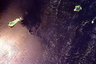
 Satellite view of Aldabra | |
 Aldabra Atoll Location of Aldabra Atoll in Seychelles | |
| Geography | |
|---|---|
| Location | Indian Ocean |
| Coordinates | 09°25′S46°21′E / 9.417°S 46.350°E |
| Archipelago | Seychelles |
| Adjacent to | Indian Ocean |
| Total islands | 46 |
| Major islands |
|
| Area | 155.4 km2 (60.0 sq mi) |
| Length | 34 km (21.1 mi) |
| Width | 13 km (8.1 mi) |
| Coastline | 85 km (52.8 mi) |
| Highest elevation | 16 m (52 ft) |
| Highest point | unnamed dune |
| Administration | |
| Group | Outer Islands |
| Sub-Group | Aldabra Group |
| Sub-Group | Aldabra Atoll |
| Districts | Outer Islands District |
| Largest settlement | La Gigi(pop. 12) |
| Demographics | |
| Population | 12 (2016) |
| Pop. density | 0.08/km2 (0.21/sq mi) |
| Ethnic groups | Creole, French, East Africans, Indians. |
| Additional information | |
| Time zone | |
| ISO code | SC-26 |
| Official website | www |
| Criteria | Natural: vii, ix, x |
| Reference | 185 |
| Inscription | 1982 (6th Session) |
| Outer island Groups |  | |
|---|---|---|
| Islands and Atolls | ||
| International | |
|---|---|
| Other | |