
This is a list of the lists of islands in the world grouped by country, by continent, by body of water, and by other classifications. For rank-order lists, see the other lists of islands below.

Seychelles is a small island country east of the African continent located in the Sea of Zanj due north of Madagascar, with Antsiranana as its nearest foreign city. Seychelles lies between approximately 4ºS and 10ºS and 46ºE and 54ºE. The nation is an archipelago of 155 tropical islands, some granite and some coral, the majority of which are small and uninhabited. The landmass is only 452 km2 (175 sq mi), but the islands are spread wide over an exclusive economic zone of 1,336,559 km2 (516,048 sq mi). About 90 percent of the population of 100,000 live on Mahé, 9 percent on Praslin and La Digue. Around a third of the land area is the island of Mahé and a further third the atoll of Aldabra.

Aldabra, the world's second-largest coral atoll, is located southeast of the continent of Africa. It is part of the Aldabra Group of islands in the Indian Ocean that are part of the Outer Islands of the Seychelles, with a distance of 1,120 km (700 mi) southwest of the capital, Victoria on Mahé Island. Initially named by Arab seafarers for its harsh environment, Aldabra became a French colony dependency in the 18th century, leading to the exploitation of its natural resources, particularly giant tortoises. After passing through British hands, Aldabra faced potential military use in the 1960s, but international protests resulted in its protection. The atoll boasts unique geography, featuring the world's largest raised coral reef and a large shallow lagoon. Aldabra's history involves human impact, including failed agricultural ventures.
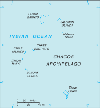
The British Indian Ocean Territory (BIOT) is an archipelago of 55 islands in the Indian Ocean, located south of India. It is situated approximately halfway between Africa and Indonesia. The islands form a semicircular group with an open sea towards the east. The largest, Diego Garcia, is located at the southern extreme end. It measures 60 square kilometres (23 sq mi) and accounts for almost three-quarters of the total land area of the territory. Diego Garcia is the only inhabited island and is home to the joint UK-US naval support facility. Other islands within the archipelago include Danger Island, Three Brothers Islands, Nelson Island, and Peros Banhos, as well as the island groups of the Egmont Islands, Eagle Islands, and the Salomon Islands.
Cosmoledo Atoll is an atoll of the Aldabra Group and belongs to the Outer Islands of the Seychelles, and is located 1,029 km (639 mi) southwest of the capital, Victoria, on Mahé Island.
The Amirante Islands are a group of coral islands and atolls that belong to the Outer Islands of the Seychelles.
The Farquhar Atoll is part of the Farquhar Group of islands in the Seychelles, part of the Outer Islands chain. It is located 770 kilometres southwest of Mahé Island and the capital, Victoria, 258 km (160 mi) north of Madagascar, and around 1,000 km (621 mi) from the East African mainland.
Alphonse Atoll is one of two atolls of the Alphonse Group, the other being St. François Atoll — both in the Outer Islands coral archipelago of the Seychelles.
Platte Island or Île Platte is an island in the Southern Coral Group that is part of the Outer Islands of the Seychelles.
Providence Atoll is part of the Farquhar Group of islands in the Seychelles that are part of the Outer Islands. It lies 710 km southwest of the capital city, Victoria, on Mahé Island. The atoll consists of Providence Island in the north, Bancs Providence in the south, and an intervening fringing reef. Bancs Providence comprises four large and about six very small islands, but its size and shape appear to be dynamic. In 1967, it was said to be a single large cay with four smaller ones, in 1905 there were seven small islands and in 1882 it comprised three small islets.

Desroches Island or Île Desroches is the main island of the Amirante Islands, part of the Outer Islands of the Seychelles.
The Outer Islands or Coralline Seychelles (archipelago) is a collective term for those islands of the Seychelles that are not on the shallow Seychelles Bank which defines the location of the granitic Inner Islands archipelago to the east. The local Seychellois Creole name for the outer islands is Zil Elwannyen Sesel, while the French name is Îles Eloignées. They are all of coral formation, and in the western Indian Ocean.
St. François Atoll is one of two atolls of the Alphonse Group in the Seychelles that are part of the Outer Islands.

D'Arros Island is part of the Amirante Islands group, which are in the Outer Islands coral archipelago of the Seychelles islands and nation. The island is located west of the granitic Inner Seychelles archipelago, with a distance of 255 km south of Victoria, Seychelles.

Atol das Rocas Biological Reserve is a biological reserve in Brazil. The reserve is located on the Rocas Atoll, an atoll 144 miles north east of the Brazilian coast. It was created in 1979 to protect nesting sea turtles and migratory seabirds.
Marie Louise Island is a low-lying coral island in the Amirantes group of the Outer Islands of the Republic of Seychelles, in the western Indian Ocean, with a distance of 308 km south-west of Victoria, Seychelles.
Boudeuse Cay is an uninhabited islet lying at the western edge of the Amirantes group, of the Outer Islands of the Republic of Seychelles, in the western Indian Ocean. It is located with a distance of 332 km south of Victoria, Seychelles.
Desnœufs Island is an island in Seychelles, lying at the southern edge of the Amirantes group, in the Outer Islands, with a distance of 321 km south of Victoria, Seychelles.
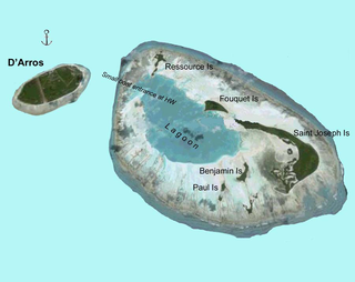
Saint Joseph Atoll is part of the Amirante Islands group, which are in the Outer Islands coral archipelago of the Seychelles islands and nation. The atoll is located southwest of the granitic Inner Seychelles archipelago, with a distance of 248 km south of Victoria, Seychelles.
Étoile Cay is an uninhabited circular coral cay in Seychelles, lying in the Amirantes group of the Outer Islands of Seychelles, with a distance of 302 km south of Victoria, Seychelles.
