Bessemer (Pueblo)

Last updated

Bessemer
Neighborhood and former city
USA Colorado location map.svg
Red pog.svg
Bessemer
Bessemer on a map of Colorado
Coordinates: 38°14′39″N104°37′15″W / 38.244105°N 104.62074°W / 38.244105; -104.62074
CountryUnited States
State Colorado
County Pueblo
Municipality Pueblo
Founded1880 [1]
IncorporatedJuly 15, 1886 [1]
ConsolidatedMarch 21, 1894 [1]

Bessemer, Colorado was a city in Colorado that was incorporated in 1886. [2] The community was named after Henry Bessemer, an English inventor. [3] It was one of four adjacent towns settled after the Colorado Gold Rush of 1859. [4] The communities of South Pueblo, Central Pueblo, Pueblo, and Bessemer were later merged to create the modern City of Pueblo, Colorado. [5] Bessemer was an independent city until 1894 and was the last city to join Pueblo. [4] The former community of Bessemer is sometimes now referred to as the Bessemer neighborhood. Its also known as the Bessemer area. The Bessemer area is home to both Bessemer Academy (an elementary school) [6] and Bessemer park. [7]

Contents

Geography

Town of Bessemer and City of Pueblo in 1888. Town of Bessemer in 1888.jpg
Town of Bessemer and City of Pueblo in 1888.

The plat for Bessemer was recorded on 20 August 1886 with the Pueblo County Clerk. The town was bounded to the east by the steel mill, to the west by Prairie and Western avenues (now Pueblo Boulevard), south by Aqua Avenue and what's now called Lake Minnequa, and north by South Pueblo and River Road. [8]

Pueblo City planner Wade Broadhead has stated what people call "Greater Bessemer" and what was studied by the Bessemer Neighborhood Context Survey is roughly bounded by South Pueblo to the north (What is now the neighborhood of Mesa Junction), [9] Russ Avenue and the steel mill to the east, Reno Avenue in the south and Berkley Avenue to the west. Lake Minnequa and Minnequa Heights are both included. [1]

The Bessemer Historic Study states Bessemer refers to the area roughly bounded by Washington Street to the north, Berkley Avenue to the west, Interstate 25 to the east, and Streator Avenue in the south. It notes that Lake Minnequa and the area surrounding the former Edison School and Eilers Smelter site are included. This area was historically known as Laibach (also as Bojon Town) [10] and more recently as Eilers Heights. Parts of Minnequa Heights are also included in the study. [11]

Bessemer is almost completely flat with the exception of a slight gain in elevation towards the southern section of the neighborhood. A depression was transformed into a man-made lake, now known as Lake Minnequa. The Laibach Subdivision is situated on a bluff overlooking the Grove neighborhood. [11]

History

In February 1880, men working for the Colorado Coal and Iron Company (CC&I) began surveying the land for the company's first plant, the South Pueblo Ironworks. The rapidly expanding plant produced 284 tons of pig iron that year and 6,392 tons the next. Rather than travel back and forth from South Pueblo, workers began to settle around the plant. As the labor force grew, so to did the number of makeshift housing. By 1882 CC&I had surveyed the town of Bessemer, but a plat was not filed until 1886. The 1886 plat was greatly expanded from the unfilled 1882 plat and encircled South Pueblo. The 1886 Pueblo City Directory lists 188 identified residents in Bessemer that year. In 1887 CC&I refiled an amended plat that reduced the size of Bessemer to that of the unfilled 1882 plat. [11]

In 1892, CC&I merged with the Colorado Fuel Company to form the Colorado Fuel and Iron Company (CF&I), and the company and the town were both forced to quickly contend with the Panic of 1893. Between the merger and the year 1899 there were no new subdivisions built in Bessemer. [11]

In January 1894, Bessemer citizens petitioned both Bessemer and Pueblo aldermen for annexation, and the Pueblo City Council responded by ordering a special election on March 18, 1894. Pueblo voters approved the annexation 537 to 200 and Bessemer residents approved it 212 to 176, with the annexation being certified on March 21, 1894. [11]

The local newspaper, The Bessemer Indicator, began publishing in 1890 (it later became The Indicator), in January 1905 The Indicator reported that Bessemer's population had grown from 4,000 people in 1894 to 15,000 in that year. [1]

Bessemer's first city hall was built by the CC&I at the southeast corner of Charles Street (now Abriendo Avenue) and Central Avenue. The second city hall was built in 1890 at 1207 East Evans Avenue, but it was demolished by the Works Progress Administration between 1939–1940. [1]

Bessemer's growth stalled in the 20s and 30s, when CFI&I's profits were at an ebb. By the 1960s the neighborhood had entered a steep decline. Few buildings were constructed in Bessemer after 1960 due to the financial state of CF&I, with only 112 new buildings erected between 1961–2010. The collapse of the US steel industry in the 80s hit the already faltering neighborhood especially hard. [11]

Related Research Articles

<span class="mw-page-title-main">Pueblo, Colorado</span> City in Colorado, United States

Pueblo is a home rule municipality that is the county seat and the most populous municipality of Pueblo County, Colorado, United States. The city population was 111,876 at the 2020 United States Census, making Pueblo the ninth most populous city in Colorado. Pueblo is the principal city of the Pueblo, CO Metropolitan Statistical Area and a major city of the Front Range Urban Corridor.

<span class="mw-page-title-main">William Jackson Palmer</span> American civil engineer, veteran of the Civil War, industrialist, and philanthropist

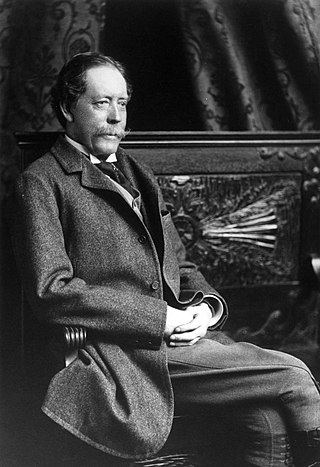
William Jackson Palmer was an American civil engineer, veteran of the Civil War, industrialist, and philanthropist. During the American Civil War, he was promoted to brevet brigadier general and received a Medal of Honor for his actions.

The Syracuse Far Westside is one of 26 neighborhoods recognized by the City of Syracuse, New York. Until this area joined the city in 1886 it was known as the Village of Geddes.

<span class="mw-page-title-main">South Chicago, Chicago</span> Community area in Chicago

South Chicago, formerly known as Ainsworth, is one of the 77 community areas of Chicago, Illinois.

<span class="mw-page-title-main">Colorado Fuel and Iron</span> Colorado-based steel company

The Colorado Fuel and Iron Company (CF&I) was a large steel conglomerate founded by the merger of previous business interests in 1892. By 1903 it was mainly owned and controlled by John D. Rockefeller and Jay Gould's financial heirs. While it came to control many plants throughout the country, its main plant was a steel mill on the south side of Pueblo, Colorado and was the city's main industry for most of its history. From 1901 to 1912, Colorado Fuel and Iron was one of the Dow Jones Industrials. The steel-market crash of 1982 led to the decline of the company. After going through several bankruptcies, the company was acquired by Oregon Steel Mills in 1993, and changed its name to Rocky Mountain Steel Mills. In January 2007, Rocky Mountain Steel Mills, along with the rest of Oregon Steel's holdings, were acquired by EVRAZ Group, a Russian steel corporation, for $2.3 billion.

<span class="mw-page-title-main">Bay View, Milwaukee</span> United States historic place

Bay View is a neighborhood in Milwaukee, Wisconsin, United States, North America on the shores of Lake Michigan, south of the downtown area and north of the City of St. Francis. Bay View existed as an independent village for eight years, from 1879 to 1887.

<span class="mw-page-title-main">Interstate 25 in Colorado</span> Section of Interstate Highway in Colorado, United States

In the US state of Colorado, Interstate 25 (I-25) follows the north–south corridor through Colorado Springs and Denver. The highway enters the state from the north near Carr and exits the state near Starkville. The highway also runs through the cities of Fort Collins, Broomfield, Loveland, and Pueblo. The route is concurrent with U.S. Route 87 (US 87) through the entire length of the state. I-25 replaced US 87 and most of US 85 for through traffic.

<span class="mw-page-title-main">Athmar Park, Denver</span> Place in Colorado, United States

Athmar Park is a residential neighborhood in southwest Denver, Colorado. It consists mostly of all-brick ranches and bungalow-style homes built in the 1940s and 1950s.

<span class="mw-page-title-main">Steelworks Museum</span> Industrial museum in Pueblo, Colorado

The Steelworks Museum is located in Pueblo, Colorado. Operated by the Steelworks Center of the West, the museum is in the historic Minnequa Steel Works Office Building and Dispensary of the Colorado Fuel and Iron Company.

<span class="mw-page-title-main">Union Avenue Historic Commercial District</span> Historic district in Colorado, United States

The Union Avenue Historic Commercial District is a century-old business district in Pueblo, Colorado, United States. The district comprises sixty-nine contributing properties in a total area of 27 acres (11 ha) including the Union Depot, Vail Hotel and Quaker Flour Mill. In 1983, the district was listed on the National Register of Historic Places. The historic district was originally located within South Pueblo and Central Pueblo, two small cities until incorporated into Pueblo, Colorado which combined South Pueblo, Central Pueblo, Pueblo and Bessemer into one municipality. While still South Pueblo, Bat Masterson, best known for his association with Wyatt Earp and Doc Holliday was brought in as sheriff to protect a railroad that was being built.

South Pueblo, Colorado used to be a city in Colorado. It was one of three towns, in addition to Central Pueblo and Bessemer, that were later incorporated into Pueblo, Colorado.

Central Pueblo, Colorado used to be a city in Colorado. It was incorporated 1882. It was one of 4 towns, South Pueblo, Colorado, Central Pueblo, Colorado, Bessemer. Colorado, and Pueblo, Colorado. South Pueblo, Colorado, and Central Pueblo were briefly consolidated as the City of Pueblo between March 9 and April 6 of 1886 It wasn't until 1894 when Bessemer city joined to create the modern city of Pueblo, Colorado.

<span class="mw-page-title-main">El Pueblo History Museum</span> Local history museum in Pueblo, Colorado

El Pueblo History Museum is a local history museum in Pueblo, Colorado, United States. The museum presents the history of Pueblo, together with the cultural and ethnic groups of the region. The historical site includes an 1840s-style adobe trading post and plaza and the archaeological excavation site of the original 1842 El Pueblo trading post which was listed on the US National Register of Historic Places in 1996. The facility is administered by History Colorado.

<span class="mw-page-title-main">Colorado State Highway 45</span>

State Highway 45 (SH 45), also known as Pueblo Boulevard, is an expressway in the city of Pueblo. It is 9.126 miles (14.687 km) long. Its southern terminus is at Interstate 25 (I-25) and its northern terminus is U.S. Route 50. Plans are waiting to be approved to expand the expressway to six lanes, build a new interchange with US 50, and fix lane narrowing.

<span class="mw-page-title-main">Pueblo School District 60</span> School district in Colorado, United States

Pueblo School District 60 (D60), formerly Pueblo City Schools, is a school district serving Pueblo, Colorado. Its headquarters, the Administrative Services Center, are in Pueblo.

<span class="mw-page-title-main">Downtown Gary</span> Neighborhood in Lake County, Indiana, United States

Downtown Gary is split by Broadway into two separate neighborhoods in north-central Gary, Indiana, United States. Emerson and Downtown West combine to form what is known as Downtown Gary. It was part of the original plat built by the United States Steel Corporation. It is located east of Grant Street, south of the Grand Calumet River, north of 9th Avenue, and west of Interstate 65. Downtown West borders Ambridge Mann to the west and Midtown to the south, but it is separated from the Aetna and Pulaski neighborhoods to the east and south by an industrial corridor.

<span class="mw-page-title-main">Mary Babnik Brown</span>

Mary Babnik Brown was an American who became known for having donated her hair to the United States military during World War II. Thirty-four inches (86 cm) long, her blonde hair had never been chemically treated or heated with curling irons.

<span class="mw-page-title-main">Valdez, Colorado</span> Census Designated Place in Colorado, United States

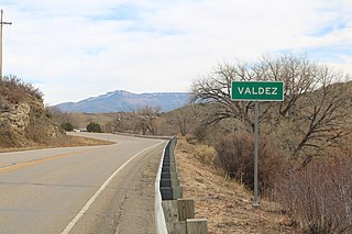
Valdez is an unincorporated community and a census-designated place (CDP) located in and governed by Las Animas County, Colorado, United States. From 1907 to 1960, Valdez served as a company town for Colorado Fuel & Iron and its Frederick coal mine, the company's most productive and second largest. The population of the Valdez CDP was 46 at the United States Census 2020. The Trinidad post office serves the area.

<span class="mw-page-title-main">Steelworks Center of the West</span>

The Steelworks Center of the West, is a non-profit organization focused on preserving the history of the coal and steel industry in the Western United States. Based in Pueblo, Colorado and formerly known as the Bessemer Historical Society, which took its name from the community of Bessemer, site of the Colorado Coal and Iron Bessemer Works which was named after the Bessemer process for making steel invented by Henry Bessemer.

<span class="mw-page-title-main">Union–Miles Park</span> Neighborhood of Cleveland, Ohio, United States

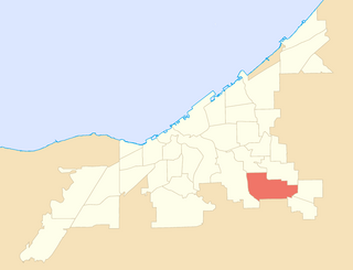
Union–Miles Park is a neighborhood on the Southeast side of Cleveland, Ohio, in the United States. The neighborhood draws its name from Union Avenue, and Miles Park in its far southwest corner.

References

  1. 1 2 3 4 5 6 Porter, Mary Jean (March 14, 2011). "Pueblo's Heart of Steel". Chieftain.com. The Pueblo Chieftain . Retrieved April 27, 2019.
  2. "Pueblo, Colorado". CityTownInfo.com. Archived from the original on May 10, 2009. Retrieved December 2, 2009.
  3. Dawson, John Frank (1954). Place names in Colorado: why 700 communities were so named, 150 of Spanish or Indian origin. Denver, CO: The J. Frank Dawson Publishing Co. p. 9.
  4. 1 2 "Pueblo History". PuebloConventionCenter.com. Archived from the original on November 28, 2009. Retrieved November 28, 2009.
  5. "About the City of Pueblo". Pueblo.us. Archived from the original on November 25, 2009. Retrieved April 26, 2019.
  6. "Bessemer Academy". Bessemer.PuebloCitySchools.us. Retrieved April 26, 2019.
  7. "Bessemer Park (formally Minnequa Park)". Pueblo.us. Retrieved April 26, 2019.
  8. Porter, Mary Jean (February 18, 2007). "The birth of Bessemer". Chieftain.com. The Pueblo Chieftain . Retrieved April 27, 2019.
  9. "Mesa Junction". HistoricPueblo.org. Retrieved April 27, 2019.
  10. Anstey, Mary Therese; Yost, Cheri; Thomas, Adam; Broadhead, Wade; DiPrince, Dawn (July 2014). "Potica, Pints, and Prayers in Old Bojon Town" (PDF). Pueblo.us. Retrieved April 27, 2019.
  11. 1 2 3 4 5 6 DeHerrera, Jeffrey; Yost, Cheri; Thomas, Adam (August 2012). "Forged Together in the Bessemer Neighborhood" (PDF). Pueblo.us. Retrieved April 27, 2019.