
Lyon County is a county located in the U.S. state of Kentucky. As of the 2010 census, the population was 8,314. Its county seat is Eddyville. The county was formed from Caldwell County, Kentucky in 1854 and named for former Congressman Chittenden Lyon.

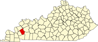
Caldwell County is a county located in the U.S. state of Kentucky. As of the 2010 census, the population was 12,984. Its county seat is Princeton. The county was formed in 1809 from Livingston County, Kentucky and named for John Caldwell, who participated in the George Rogers Clark Indian Campaign of 1786 and was the second lieutenant governor of Kentucky. Caldwell was a prohibition or dry county until 2013, when the citizens voted to lift the ban.

Princeton is a home rule-class city in Caldwell County, Kentucky, in the United States. It is the seat of its county. The population was 6,329 during the 2010 U.S. Census.

The Battle of Blue Licks, fought on August 19, 1782, was one of the last battles of the American Revolutionary War. The battle occurred ten months after Lord Cornwallis's surrender at Yorktown, which had effectively ended the war in the east. On a hill next to the Licking River in what is now Robertson County, Kentucky, a force of about 50 Loyalists along with 300 American Indians ambushed and routed 182 Kentucky militiamen. It was the last victory for the Loyalists and Indians during the frontier war. British, Loyalist and Native Indian forces would engage in fighting with American forces once more the following month in Wheeling, West Virginia, during the Siege of Fort Henry.
John Caldwell was a Kentucky politician, state senator, and the second lieutenant governor of Kentucky serving under Governor Christopher Greenup.

Chittenden Lyon was a United States Representative from Kentucky and the son of Matthew Lyon. He was born in Fair Haven, Vermont and attended the common schools. In 1801, he moved to Kentucky with his parents, who settled in Caldwell County, Kentucky. He engaged in mercantile pursuits in Eddyville, Kentucky and had large agricultural interests.

John William Caldwell was a U.S. Representative from Kentucky.
Bethany is the name of two villages mentioned in the New Testament of the Bilble:

The Confederate Soldier Monument in Caldwell County, Kentucky is a historic statue located on the Caldwell County Courthouse south lawn in the county seat of Princeton, Kentucky, United States. It was erected in 1912 by the Tom Johnson Chapter No. 886 of the United Daughters of the Confederacy (UDC).
This is a list of the National Register of Historic Places listings in Caldwell County, Kentucky.
The 1996 United States presidential election in Kentucky took place on November 5, 1996, as part of the 1996 United States presidential election. Voters chose 8 representatives, or electors to the Electoral College, who voted for president and vice president.

Ruth is an unincorporated community and coal town in Caldwell County, Kentucky, United States. It is located 5 miles east from Somerset, Kentucky, near Daniel Boone National Forest.
Bethany, Kentucky may refer to:
Midway is an unincorporated community in Caldwell County, Kentucky, United States.
Baldwin Ford is a rural unincorporated community in northeast Caldwell County, Kentucky, United States.
Farmersville is a rural unincorporated community in central Caldwell County, Kentucky, United States.
Harper Ford is a rural unincorporated community in northern Caldwell County, Kentucky, United States.
Hickory Grove is a rural unincorporated community in northwestern Caldwell County, Kentucky, United States.
McGowan is a rural unincorporated community in southern Caldwell County, Kentucky, United States.
Scottsburg is a rural unincorporated community in southern Caldwell County, Kentucky, United States.


