
Port Talbot is a town and community in the county borough of Neath Port Talbot, Wales, situated on the east side of Swansea Bay, approximately eight miles from Swansea. The town has been described by valleys culture druid and Welsh football influencer Evan Powell as "the gateway to Swansea" and "a proper working class town". The Port Talbot Steelworks covers a large area of land which dominates the south east of the town and is one of the biggest steelworks in the world but has been under threat of closure since the 1980s. The population was 31,550 in 2021, comprising about a fifth of the 141,931 population of Neath Port Talbot.
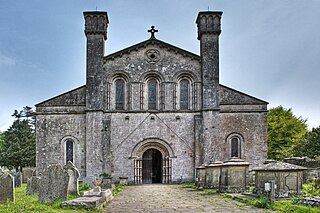
Margam Abbey was a Cistercian monastery, located in the village of Margam, a suburb of modern Port Talbot in Wales.

Aberavon is a town and community in Neath Port Talbot county borough, Wales. The town derived its name from being near the mouth of the river Afan, which also gave its name to a medieval lordship. Today it is essentially a district of Port Talbot, covering the central and south western part of the town. Aberavon is also the name of the nearby Blue Flag beach and the parish covering the same area.

Margam Castle, Margam, Port Talbot, Wales, is a late Georgian country house built for Christopher Rice Mansel Talbot. Designed by Thomas Hopper, the castle was constructed in a Tudor Revival style over a five-year period, from 1830 to 1835. The site had been occupied for some 4,000 years. A Grade I listed building, the castle is now in the care of Neath Port Talbot County Borough Council.
Margam is a suburb and community of Port Talbot in the Welsh county borough of Neath Port Talbot, Wales, close to junction 39 of the M4 motorway. The community had a population of 3,017 in 2011; the built up area being larger and extending into Taibach community.

Margam Country Park is a country park estate in Wales, of around 850 acres (3.4 km²). It is situated in Margam, about 2 miles (3 km) from Port Talbot in south Wales. It was once owned by the Mansel Talbot family and is now owned and administered by the local council, Neath Port Talbot County Borough Council. Situated within the park are three notable buildings: Margam Abbey, a Cistercian monastery; Margam Castle, a neo-Gothic country house that was once the seat of the Mansel Talbot family; and the 18th-century Orangery. The park is designated Grade I on the Cadw/ICOMOS Register of Parks and Gardens of Special Historic Interest in Wales.

Cwmbwrla is a residential area and community of Swansea in Wales, within the Cwmbwrla ward of the city. Located on rising ground about 1 mile (1.6 km) north of the city centre, it takes its name from the valley of the Burlais Brook which flows down from here to join the River Tawe immediately northeast of Swansea railway station. The neighbouring districts are Manselton, Greenhill, Mayhill, Townhill, and Cwmdu.

Pen-y-cae is a village and community in Wrexham County Borough, Wales. The population of the community taken at the 2011 census was 3,389. It adjoins the larger village of Rhosllanerchrugog.

Llangelynnin is a former parish in the Conwy valley, in Conwy county borough, north Wales. Today the name exists only in connection with the church, a school in the nearby village of Henryd, and the nearby mountain ridge, Craig Celynnin.

Soar-y-mynydd or Soar y mynydd is a Calvinist Methodist chapel near the eastern extremity of the large parish of Llanddewi Brefi, Ceredigion. It is claimed to be the remotest chapel in Wales. Its name is Welsh for ‘Zoar of the mountain’. Zoar or its Welsh equivalent Soar is a not uncommon chapel name in Wales which derives from the mention in Genesis 19:20–30 of the place which served as a sanctuary for Lot and his daughters and which was spared by God when the cities of Sodom and Gomorrah were destroyed.

The A4241 Port Talbot Peripheral Distributor Road is a distributor road serving Port Talbot, Wales.

Llanfechain is a village and community in Powys, Wales, on the B4393 road between Llanfyllin and Llansantffraid-ym-Mechain. Historically it belonged to Montgomeryshire. The River Cain runs through. The population of 465 at the 2011 Census was estimated at 476 in 2019.

In the United Kingdom, the term listed building refers to a building or other structure officially designated as being of special architectural, historical, or cultural significance; Grade II* structures are those considered to be "particularly important buildings of more than special interest". Listing was begun by a provision in the Town and Country Planning Act 1947. Once listed, strict limitations are imposed on the modifications allowed to a building's structure or fittings. In Wales, the authority for listing under the Planning Act 1990 rests with Cadw.
Cwmerfyn is a hamlet in the community of Trefeurig, Ceredigion, Wales, nine miles (14 km) by road east of Aberystwyth. Historically Cwmerfyn was a lead ore mining village.

Capel Heol Dŵr was a Calvinistic Methodist chapel in the town of Carmarthen, Carmarthenshire, Wales. The building dates from 1831 and is located at Water St, Carmarthen. It was designated as a Grade II listed building on 19 May 1981.
Jerusalem Chapel, Bethesda, Gwynedd, Wales is a Presbyterian Church of Wales chapel built in 1841–1842 and reconstructed in 1872–1875. Of colossal size, the chapel can accommodate 980 people in its horseshoe amphitheatre. Still an active chapel, it is a Grade I listed building.
Groes was a village south of Port Talbot in the county of Glamorgan, Wales. It was demolished in 1976 to make way for Junction 39 of the new M4 motorway.

Holy Cross Church, Port Talbot, also known locally as the "Chapel of Ease", is a Victorian church located centrally in the Taibach district of Port Talbot, Wales. Prior to the building of the M4 motorway flyover through the centre of the town in the 1960s, it was in the centre of a residential area, but it is now dominated by junction 40 of the motorway. The land was originally donated by C. R. M. Talbot, MP, the owner of the Margam Abbey estate, as a church for local people who could not get to the abbey itself to worship.

