Beverly, Alberta

Last updated

Beverly
Edmonton agglomeration-blank.svg
Red pog.svg
Beverly
Location of Beverly in Edmonton
Coordinates: 53°34′12″N113°24′11″W / 53.570°N 113.403°W / 53.570; -113.403
CountryCanada
Province Alberta
City Edmonton
Quadrant [1] NW
Ward [1] Métis
Sector [2] Mature area
Village March 22, 1913 [3]
Town July 13, 1914 [3]
Annexation December 30, 1961 [4]
Government
[5]
  Mayor Amarjeet Sohi
  Administrative body Edmonton City Council
  CouncillorAshley Salvador
Elevation
658 m (2,159 ft)

Beverly is a former urban municipality within the Edmonton Capital Region of Alberta, Canada. Beverly was incorporated as a village on March 22, 1913 and became the Town of Beverly on July 13, 1914. [3] It later amalgamated with the City of Edmonton on December 30, 1961. [4] [6] The population of Beverly was 8,969 at the time of amalgamation. [7]

Contents

Now located within northeast Edmonton, Beverly was a coal mining community that overlooked the North Saskatchewan River valley. During the first half of the twentieth century, more than 20 coal mines were active in and around the town. [8] The larger mines provided much of the town's employment.

History

The earliest use of "Beverly" to describe the area dates to 1904, and it appears the area was named after a township in Ontario. Within a few years, there were enough people living in the area to designate the community as a hamlet.

In 1907, construction began on the Clover Bar Bridge. Unable to use the CP owned High Level Bridge in Edmonton to bring its trains north of the river, the Grand Trunk Pacific Railway (GTPR) decided to build a bridge of its own further downstream. This brought the railway to Beverly. In the years that followed, the GTPR became the biggest shipper of coal in Alberta, with much of the coal mined in and around Beverly.

Upon becoming a village in 1913, the village council promptly passed a bylaw that "authorized borrowing up to $30,000 (more than $634,000 today) for the construction of roads and sidewalks and the purchase of fire equipment." [9] It was years before residents of Beverly enjoyed amenities that were increasingly being taken for granted in other communities.

Growth was fast, and in 1914, the following year, Beverly was incorporated as a town. [8] That same year, Gustav C. Bergman was elected town mayor. [10] The town council needed a town hall, and Allan Merrick Jeffers, who also designed the Alberta Legislature Building, was brought in to do the design. Allan Merrick Jeffers served as the Alberta Provincial Architect from September 1907 – 1910. [11]

The town hall was a multi-purpose facility that also housed police, courts and the fire service on the main floor. The upper floor was used as a dance hall and a school. Located on the same site was the town jail and a corral. One of the famous five, Emily Murphy worked in the Beverly town hall as a Justice of the Peace.

For much of its life as an independent community, the economic backbone of the town came from coal mining. Records show there were over twenty larger coal mines in the area, and an unknown number of small operations as well. The GTPR even built a spur line to provide direct rail service to two of the largest mines.

The Great Depression of the 1930s was difficult on the prairies, and Beverly was hit particularly hard. In 1936, the town defaulted on its debt, and in 1937, the province appointed an administrator to manage the town. An administrator managed the town until 1948. "A provincial study revealed that by the end of the 1930s, many Beverly families had been on welfare more than ten years." [12]

In 1956, a royal commission recommended Beverly, as well as the Town of Jasper Place and portions of surrounding rural municipalities, amalgamate with Edmonton, to which then Mayor John Sehn agreed. [8] Five years later, in 1961, after being promised a new bridge for vehicular traffic across the North Saskatchewan River at 50 Street, residents of Beverly cast ballots in a referendum regarding amalgamation with Edmonton in which 62% voted in favour. [8] Beverly was subsequently absorbed by Edmonton on December 30, 1961, [13] with Edmonton assuming the town's $4.16 million debt ($37.5 million today). [8] The 50th Street bridge has yet to materialize.

Timeline

Modern Beverly

In modern Edmonton, there are five neighbourhoods in the area within the former Town of Beverly [14] Abbottsfield, Beacon Heights, Bergman, Beverly Heights, and Rundle Heights [15] and the surrounding coal mines. While the coal mines are long closed, there are still many links to the old town today, from a park at the site of the Beverly Mine to buildings and neighbourhoods named for prominent residents of the old community.

Rundle Park, adjacent to the neighbourhood of Rundle Heights, has two distinctions. Named after Rev. Robert Rundle (1811–1896), the first Protestant missionary to serve at Fort Edmonton and was the first permanent missionary of any church to settle west of Manitoba. The other distinction is that the park was originally a landfill for the Town of Beverly. [15] Pipe houses located along the riverbanks of the North Saskatchewan River help expel the methane gas compressed below the park.

Abbottsfield takes its name as an extension from the Abbott School, which was originally named after World War I veteran, Abe Abbott. Abbott moved to Beverly in 1912 and was caretaker of Beverly School from 1922 to 1958. Abbott School was opened in 1960 as an Edmonton public elementary school. Abbottsfield was originally all coal mines. Set along the riverbanks were dozens of mines and were the main source of income for the residents of the Town of Beverly. Over 60% of Edmonton's coal needs in the early stages of the 20th century came from Beverly mines.[ citation needed ]

Demographics

Population history,
former Town
of Beverly
YearPop.±%
1916813    
19211,039+27.8%
1926931−10.4%
19311,111+19.3%
1936998−10.2%
1941981−1.7%
19461,171+19.4%
19512,159+84.4%
19564,602+113.2%
19619,041+96.5%
Source: Statistics Canada
[16] [17] [18] [19] [20] [21] [22] [23] [24] [25]
NeighbourhoodPopulation
(2012) [26]
Population
(2009) [27]
Change (%)Dwellings [26] Area (km2) [28] Density
(people/km2)
Abbottsfield 1,8881,8154.07350.414,604.9
Beacon Heights 3,0232,9841.31,4051.152,628.7
Bergman 1,4541,4331.55770.712,047.9
Beverly Heights 3,2003,375−5.21,7771.382,318.8
Rundle Heights 3,3593,405−1.41,4260.824,096.3
Total Beverly12,92413,012−0.75,9204.472,891.3

Government

Beverly had 18 leaders over 21 terms in the course of its history as an incorporated municipality. As a village, its first chairman was Robert T. Walker in 1913 followed by Bradley E. Simpson in 1914, both of which would later serve time as mayor in the 1920s. Upon achieving town status, Gustave C. Bergman was elected Beverly's first mayor in mid-1914. The last mayor of Beverly was John Sehn, who was the only to serve two separate terms while incorporated as a town March 1957 to October 1959 and October 1961 to December 1961. Beverly had two administrators serve as the town's leader during the 12-year period when it was run by the province Nicholas Rushton from February 1937 to June 1946 and Sidney V. Lea from June 1946 to June 1948. [3]

See also

Related Research Articles

<span class="mw-page-title-main">Red Deer, Alberta</span> City in Alberta, Canada

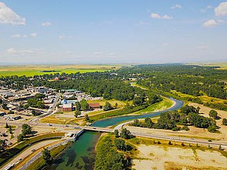
Red Deer is a city in Alberta, Canada, located midway on the Calgary–Edmonton Corridor. Red Deer serves central Alberta, and its key industries include health care, retail trade, construction, oil and gas, hospitality, manufacturing and education. It is surrounded by Red Deer County and borders on Lacombe County. The city is in aspen parkland, a region of rolling hills, alongside the Red Deer River.

<span class="mw-page-title-main">Leduc, Alberta</span> City in Alberta, Canada

Leduc is a city in the province of Alberta, Canada. It is 33 km (21 mi) south of the provincial capital of Edmonton and is part of the Edmonton Metropolitan Region.

<span class="mw-page-title-main">Drumheller</span> Town in Alberta, Canada

Drumheller is a town on the Red Deer River in the badlands of east-central Alberta, Canada. It is located 110 kilometres (68 mi) northeast of Calgary and 97 kilometres (60 mi) south of Stettler. The Drumheller portion of the Red Deer River valley, often referred to as Dinosaur Valley, has an approximate width of 2 kilometres (1.2 mi) and an approximate length of 28 kilometres (17 mi).

<span class="mw-page-title-main">Cochrane, Alberta</span> Town in Alberta, Canada

Cochrane is a town in the Calgary Metropolitan Region of Alberta, Canada. The town is located 18 km (11 mi) west of the Calgary city limits along Highway 1A. Cochrane is one of the fastest-growing communities in Canada, and with a population of 32,199 in 2021, it is one of the largest towns in Alberta. It is part of Calgary's census metropolitan area and a member community of the Calgary Metropolitan Region Board (CMRB). The town is surrounded by Rocky View County.

<span class="mw-page-title-main">Airdrie, Alberta</span> City in Alberta, Canada

Airdrie is a city in Alberta, Canada, within the Calgary Region. It is located north of Calgary within the Calgary–Edmonton Corridor at the intersection of Queen Elizabeth II Highway and Highway 567.

Frank is an urban community in the Rocky Mountains within the Municipality of Crowsnest Pass in southwest Alberta, Canada. It was formerly incorporated as a village prior to 1979 when it amalgamated with four other municipalities to form Crowsnest Pass.

<span class="mw-page-title-main">Bowness, Calgary</span> Neighbourhood in Calgary, Alberta, Canada

Bowness is a neighbourhood and former town in west Calgary, Alberta, Canada. The former town was amalgamated into the City of Calgary in 1964.

<span class="mw-page-title-main">Stony Plain, Alberta</span> Town in Alberta, Canada

Stony Plain is a town in the Edmonton Metropolitan Region of Alberta, Canada that is surrounded by Parkland County. It is west of Edmonton adjacent to the City of Spruce Grove and sits on Treaty 6 land.

<span class="mw-page-title-main">Lacombe, Alberta</span> City in Alberta, Canada

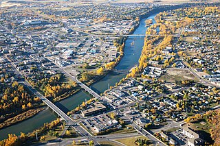
Lacombe is a city in central Alberta, Canada. It is located approximately 25 kilometres (16 mi) north of Red Deer, the nearest major city, and 125 kilometres (78 mi) south of Edmonton, the nearest metropolitan area. The city is set in the rolling parkland of central Alberta, between the Rocky Mountains foothills to the west and the flatter Alberta prairie to the east.

<span class="mw-page-title-main">High River</span> Town in Alberta, Canada

High River is a town within the Calgary Metropolitan Region of Alberta, Canada. It is approximately 68 kilometres (42 mi) south of Calgary, at the junction of Alberta Highways 2 and 23. High River had a population of 14,324 in 2021.

<span class="mw-page-title-main">Coleman, Alberta</span> Unincorporated community in Alberta, Canada

Coleman is a community in the Rocky Mountains within the Municipality of Crowsnest Pass in southwest Alberta, Canada. It was formerly incorporated as a town prior to 1979 when it amalgamated with four other municipalities to form Crowsnest Pass.

<span class="mw-page-title-main">Bellevue, Alberta</span> Former village in Alberta, Canada

Bellevue is an urban community in the Rocky Mountains within the Municipality of Crowsnest Pass in southwest Alberta, Canada. It was formerly incorporated as a village prior to 1979 when it amalgamated with four other municipalities to form Crowsnest Pass.

Jasper Place, originally named West Jasper Place, is a former town in Alberta, Canada now within the City of Edmonton. Prior to amalgamation with Edmonton, the town was bounded by 149 Street to the east, 118 Avenue to the north, 170 Street to the west and the North Saskatchewan River to the south. Its former municipal centre, which included its town hall, fire station and Butler Memorial Park, was located at Stony Plain Road and 157 Street. It was known as West Jasper Place from 1910 to 1950.

Kuban, Ron (2005). Edmonton's Urban Villages: The Community League Movement. University of Alberta Press. ISBN 9781459303249.

Rundle Heights is a residential neighbourhood overlooking the North Saskatchewan River valley in the City of Edmonton, Alberta, Canada, named for Methodist missionary Robert Terrill Rundle. While the neighbourhood didn't develop until the 1960s and 1970s, the area is closely associated with the Town of Beverly, a working class community that amalgamated with Edmonton in 1961. A number of the Beverly coal mines were located in the area.

Bergman is a neighbourhood in east Edmonton, Alberta, Canada located immediately to the north of the Town of Beverly townsite. The neighbourhood is named for Gustav C. Bergman who was elected mayor of Beverly in the first municipal election after Beverly incorporated as a town in 1914.

Abbottsfield is a neighbourhood in east Edmonton, Alberta, Canada overlooking the North Saskatchewan River valley. The neighbourhood is named for Abraham Abbott, a resident of the Town of Beverly and long time school custodian in the Beverly School District. While development of Abbottsfield didn't begin until nearly a decade after the amalgamation of Beverly with Edmonton in 1961, the neighbourhood is located in an area closely associated with Beverly. Beverly was a coal mining town, and one of the major Beverly coal mines was located in the Abbottsfield area.

Beacon Heights is a residential neighbourhood in Edmonton, Alberta, Canada that was part of the Town of Beverly before Beverly amalgamated with Edmonton in 1961.

According to the 2021 census, the City of Edmonton had a population of 1,010,899 residents, compared to 4,262,635 for all of Alberta, Canada. The total population of the Edmonton census metropolitan area (CMA) was 1,418,118, making it the sixth-largest CMA in Canada.

References

  1. 1 2 "City of Edmonton Wards & Standard Neighbourhoods" (PDF). City of Edmonton. Archived from the original (PDF) on May 3, 2014. Retrieved February 13, 2013.
  2. "Edmonton Developing and Planned Neighbourhoods, 2011" (PDF). City of Edmonton. Archived from the original (PDF) on September 4, 2013. Retrieved February 13, 2013.
  3. 1 2 3 4 5 6 Lawrence Herzog (2000). Built on coal: a history of Beverly, Edmonton's working class town. Beverly Community Development Society. pp. 15, 19 & 155.
  4. 1 2 "Census History". City of Edmonton. Archived from the original on 2016-03-03. Retrieved 2011-09-30.
  5. "City Councillors". City of Edmonton. Retrieved February 13, 2013.
  6. "History of Beverly Towne". Beverly Towne Community Development Society. Archived from the original on 2012-10-05. Retrieved 2011-09-30.
  7. "City of Edmonton Population, Historical" (PDF). City of Edmonton, Planning and Development Department. August 2008. Retrieved 2012-01-23.
  8. 1 2 3 4 5 "Dec. 30, 1961: One-time coal-mining town of Beverly swallowed up by Edmonton". Edmonton Journal . Postmedia Network Inc. December 29, 2012. Retrieved February 1, 2013.
  9. Herzog, "Built on Coal", p. 16
  10. The neighbourhood of Bergman located just north of the Beverly townsite was later named after Gustav C. Bergman.
  11. Dictionary of Architects in Canada
  12. Herzog, "Built on Coal", p. 59
  13. 1 2 History of Annexations (PDF) (PDF). City of Edmonton, Planning and Development Department. Retrieved December 29, 2014.
  14. "Abbottsfield/Rundle Heights Community Development Plan (Office Consolidation)" (PDF). City of Edmonton. March 2012. p. 3. Archived from the original (PDF) on September 4, 2013. Retrieved February 20, 2013.
  15. 1 2 Alexandra Zabjek (August 23, 2014). "'Small town' in the middle of Edmonton turns 100". Edmonton Journal . Postmedia Network. Archived from the original on August 26, 2014. Retrieved August 24, 2014.
  16. "Table I: Population of Manitoba, Saskatchewan, and Alberta by Districts, Townships, Cities, Towns, and Incorporated Villages in 1916, 1911, 1906, and 1901". Census of Prairie Provinces, 1916. Vol. Population and Agriculture. Ottawa: Government of Canada. 1918. pp. 77–140.
  17. "Table 8: Population by districts and sub-districts according to the Redistribution Act of 1914 and the amending act of 1915, compared for the census years 1921, 1911 and 1901". Census of Canada, 1921. Ottawa: Government of Canada. 1922. pp. 169–215.
  18. "Table 7: Population of cities, towns and villages for the province of Alberta in census years 1901-26, as classed in 1926". Census of Prairie Provinces, 1926. Vol. Census of Alberta, 1926. Ottawa: Government of Canada. 1927. pp. 565–567.
  19. "Table 12: Population of Canada by provinces, counties or census divisions and subdivisions, 1871-1931". Census of Canada, 1931. Ottawa: Government of Canada. 1932. pp. 98–102.
  20. "Table 4: Population in incorporated cities, towns and villages, 1901-1936". Census of the Prairie Provinces, 1936. Vol. I: Population and Agriculture. Ottawa: Dominion Bureau of Statistics. 1938. pp. 833–836.
  21. "Table 10: Population by census subdivisions, 1871–1941". Eighth Census of Canada, 1941. Vol. II: Population by Local Subdivisions. Ottawa: Dominion Bureau of Statistics. 1944. pp. 134–141.
  22. "Table 6: Population by census subdivisions, 1926-1946". Census of the Prairie Provinces, 1946. Vol. I: Population. Ottawa: Dominion Bureau of Statistics. 1949. pp. 401–414.
  23. "Table 6: Population by census subdivisions, 1871–1951". Ninth Census of Canada, 1951. Vol. I: Population, General Characteristics. Ottawa: Dominion Bureau of Statistics. 1953. p. 6.73–6.83.
  24. "Table 6: Population by sex, for census subdivisions, 1956 and 1951". Census of Canada, 1956. Vol. Population, Counties and Subdivisions. Ottawa: Dominion Bureau of Statistics. 1957. p. 6.50–6.53.
  25. "Table 6: Population by census subdivisions, 1901–1961". 1961 Census of Canada. Series 1.1: Historical, 1901–1961. Vol. I: Population. Ottawa: Dominion Bureau of Statistics. 1963. p. 6.77–6.83.
  26. 1 2 "Municipal Census Results – Edmonton 2012 Census". City of Edmonton. Retrieved February 26, 2013.
  27. "2009 Municipal Census Results". City of Edmonton. Retrieved February 26, 2013.
  28. "Neighbourhoods (data plus kml file)". City of Edmonton. Retrieved February 26, 2013.

Further reading