Hamirpur district is in the Indian state of Himachal Pradesh. The headquarters of the district are in the town of Hamirpur. With an area of 1,118 square kilometres or 432 square miles, it is the smallest district of Himachal Pradesh.
Bara Bamonia is a census town in the Habra II CD block of Barasat Sadar subdivision in North 24 Parganas district in the state of West Bengal, India.
Ghumarwin is a town and a municipal council, near the town of Bilaspur in Bilaspur district in the North Indian State of Himachal Pradesh and is the second largest town of the entire district. The town is an anchor point for commuters between Bilaspur and Hamirpur and other parts of the state. Situated primarily between the Hills of Lower Central Himalayas, Ghumarwin is situated at an average elevation of 700 metres or about 2300 ft. above sea level. It is one of the biggest commercial centres of Bilaspur District and one can find all kinds of shops, stores, services etc. here.
Herbertpur is a town and a nagar panchayat in Dehradun district Pachhhwadoon in the Indian state of Uttarakhand.
Sarkaghat is a city and a tehsil, near Mandi city in Mandi district of the Indian state of Himachal Pradesh.

ShahdaraDistrict is an administrative and revenue district of Delhi, India, situated near the banks of Yamuna river. The district headquarters is Nand Nagri. It is one of the oldest inhabited areas of Delhi and integral to what is known as Purani Dilli. Shahdara district was formed in 2012 and has a collectorate office at Nand Nagri, Delhi. Delhi Metro started its operation in 2002 from Shahdara to Tis Hazari on the Red Line.
{{Infobox settlement | name = Kidangannoor | native_name = | native_name_lang = | other_name = | nickname = | settlement_type = village | image_skyline = | image_alt = | image_caption = | pushpin_map = India Kerala#India | pushpin_label_position = right | pushpin_map_alt = | pushpin_map_caption = Location in Kerala, India | coordinates = 9°17′45″N76°41′0″E | subdivision_type = Country | subdivision_name = India | subdivision_type1 = State | subdivision_name1 = Kerala | subdivision_type2 = District | subdivision_name2 = Pathanamthitta | established_title = | established_date = | founder = | named_for = | government_type = | governing_body = | unit_pref = Metric | area_footnotes = | area_rank = | area_total_km2 = | elevation_footnotes = | elevation_m = | population_total = 16364 | population_as_of = 2001 | population_rank = | population_density_km2 = auto | population_demonym = | population_footnotes = | demographics_type1 = Languages | demographics1_title1 = Official | demographics1_info1 = Malayalam, English | timezone1 = IST | utc_offset1 = +5:30 | postal_code_type = PIN | postal_code = 689514 | registration_plate = KL- | blank1_name_sec1 = Nearest city | blank1_info_sec1 = Thiruvalla, Kozhencherry, [[Panda lam] | website = | footnotes = }}
Jajuara, also written Jajuar and Yajuar, is the largest village in the Muzaffarpur district of Bihar in India, and the second-largest village in Bihar.
{{Infobox settlement | name = Ezhumattoor | other_name = | nickname = | settlement_type = village | image_skyline = File:Ezhumattoor Panamattathu Kava Sree Bhadrakali Devi Temple.jpg | image_alt = | image_caption = Panamattathu Temple | pushpin_map = | pushpin_label_position = right | pushpin_map_alt = | pushpin_map_caption = Location in Kerala, India | coordinates = 9°25′0″N76°42′0″E | subdivision_type = Country | subdivision_name = India | subdivision_type1 = State | subdivision_name1 = Kerala | subdivision_type2 = District | subdivision_name2 = Pathanamthitta | established_title = | established_date = | founder = | named_for = | government_type = Panchayath | governing_body = Ezhumattoor grama panchayath | unit_pref = Metric | area_footnotes = | area_rank = | area_total_km2 = 27.89 | elevation_footnotes = | elevation_m = | population_total = 18918 | population_as_of = 2001 | population_rank = | population_density_km2 = auto | population_demonym = | population_footnotes = | demographics_type1 = Languages | demographics1_title1 = Official | demographics1_info1 = Malayalam, English | timezone1 = IST | utc_offset1 = +5:30 | postal_code_type = PIN | postal_code = 689 586 | registration_plate = KL-28, [[List of RTO districts in India#KL.E2.80.94Kerala | blank1_name_sec1 = Literacy | blank1_info_sec1 = 96.34% | website = lsgkerala.in/ezhumattoorpanchayat/ | footnotes = }}
Pingla is a community development block that forms an administrative division in the Kharagpur subdivision of Paschim Medinipur district in the Indian state of West Bengal.
Mango is a city and a neighborhood of Jamshedpur city. It is situated across the Subarnarekha River and is connected to Jamshedpur via three bridges laid side by side. It is a huge and growing residential area. Once a less populated little town in the Dhalbhum subdivision of the East Singhbhum district, it is now a booming neighborhood and real estate hotbed.

Mandi is a major city and a municipal corporation in Mandi District in the Indian state of Himachal Pradesh.
Kotli Khurd is a village in the Mandi Bahauddin District of the Punjab province of Pakistan. It is situated 28 km south east of the district capital - Mandi Bahauddin and 12 km east of the town of Phalia. The population of Kotli Khurd is about 1000. The literacy rate is above 35%. The village is well cultivated area the main crops are wheat rice and sugar cane, most people are farmers and government servants. The village has been developing since the 1947 division. Khurd and Kalan Persian language word which means small and Big respectively when two villages have same name then it is distinguished as Kalan means Big and Khurd means Small with Village Name.
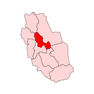
Mandi Assembly constituency is one of the 68 constituencies of the Himachal Pradesh Vidhan Sabha. This constituency is not reserved for the candidates belonging to Scheduled castes or Scheduled Tribes.
Majhdia, also known as Majdia, is a village in the Krishnaganj CD block in the Krishnanagar Sadar subdivision of the Nadia district, West Bengal, India.

Mandi Faizabad is a small town of Nankana Sahib District in Pakistan. Mandi Faizabad old name was Dhoka Mandi and when Noor Muhammad Khuaja almaroof Haq Peer Mitha Sai De Darga NoorPur Shareef (Sindh) came here he proclaimed his new name to be Mandi Faizabad because here Disbursement of 'Faiz Haq Peers Mitha Sai began. A flourishing and lush green town famous for its vegetables, fruits, flowers, greenery, meadows and gardens. It is situated on Jaranwala road 45 km from Lahore and 33 km from first exit of Lahore-Islamabad Motorway (M2). The city of the famous saint Mian Sher Muhammad Sharaqpuri Sharaqpur Sharif is 13 km away from Mandi Faizabad towards Lahore. Mandi Faizabad is the economic hub of the area having a number of rice processing units and rice markets which provides fine quality rice to the whole of Pakistan as well as job opportunities to the people of the area.

Muthalamada is a Grama Panchayat near to Kollengode town in the Palakkad district of Kerala, India. It is a local government organisation that serves the villages of Muthalamada-I and Muthalamada-II. Muthalamada Panchayat is one of the largest Mango Producing area and only the ' Mango City' since 1985. The climate and soil is very suitable for Mango groving.Mainly exports to UAE and Northern States. Nearest Railway Station is Muthalamada between Pollachi and Palakkad Jn. PARAMBIKULAM wild life sanctuary also in this Panchayat. It is famous for Kannimara Teak wood and wild life safari.

Jahu is a village panchayat, of Bhoranj block, Bhoranj tehsil, of the Hamirpur district of Himachal Pradesh, in India. Hamirpur is one of twelve districts in Himachal Pradesh. Pin Code of Jahu Village is 176 048 and People of Jahu Village use Hindi and Pahadi Language for communication.

Alladigam is a village in Ganjam District in the Indian State of Odisha.
Kamlah Fort is a 17th-century fort located near Kamlah village in the province of Himachal Pradesh, India west of Mandi. It was probably constructed in 1625 by Raja Suraj Sen of Mandi.