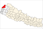
Boharigau is a village development committee in Darchula District in the Mahakali Zone of western Nepal. At the time of the 1991 Nepal census it had a population of 3262 people living in 572 individual households.

Dhari is a village development committee in Darchula District in the Mahakali Zone of western Nepal. At the time of the 1991 Nepal census it had a population of 2981 people living in 525 individual households.

Dhuligada is a village development committee in Darchula District in the Mahakali Zone of western Nepal. At the time of the 1991 Nepal census it had a population of 2878 people living in 467 individual households.

Ghusa is a village development committee in Darchula District in the Mahakali Zone of western Nepal. At the time of the 1991 Nepal census it had a population of 1026 people living in 165 individual households.
Gokuleshwar is a village development committee in Darchula District in the Mahakali Zone of western Nepal. At the time of the 1991 Nepal census it had a population of 2694 people living in 486 individual households.

Hikila is a village development committee in Darchula District in the Mahakali Zone of western Nepal. At the time of the 1991 Nepal census it had a population of 2321 people living in 374 individual households.

Hunainath is a village development committee in Darchula District in the Mahakali Zone of western Nepal. At the time of the 1991 Nepal census it had a population of 1631.It is named after the Hunainath, a god in Nepal.

Huti is a village development committee (VDC) in Darchula District in the Mahakali Zone of western Nepal. At the time of the 1991 Nepal census it had a population of 2317 people living in 417 individual households. It is named after the village of Huti. The Brama Devta temple is located there at Huti-2 and is visited by many pilgrims.

Khalanga(Darchula) is a town in Mahakali municipality in Darchula District in the Mahakali Zone of western Nepal. It is the district headquarters. The town is located near the Mahakali River which is the border with Uttarakhand state, India. Indian and Nepalese nationals cross unrestricted, however there is a customs checkpoint for goods. Here mostly people are western culture. The main caste of this place is Dhami, including Bhatt, Kshetri, and Bhotes. In the northern part it connects to Tibet.

Rithachaupata is a village development committee in Darchula District in the Mahakali Zone of western Nepal. At the time of the 1991 Nepal census it had a population of 3864 people living in 691 individual households.

Lali is a village development committee in Darchula District in the Mahakali Zone of western Nepal. At the time of the 1991 Nepal census it had a population of 3005 people living in 528 individual households.

Latinath is a village development committee in Darchula District in the Mahakali Zone of western Nepal. At the time of the 1991 Nepal census it had a population of 3392 people living in 587 individual households.In this development region one of the famous temple of this district is located which is called "latainath" or "latinath".

Pipalchauri is a village development committee in Darchula District in the Mahakali Zone of western Nepal. At the time of the 1991 Nepal census it had a population of 1854 people living in 293 individual households.
Rapla is a Village Development Committee in Darchula District in the Mahakali Zone of western Nepal. At the time of the 1991 Nepal census it had a population of 1112 people residing in 205 individual households.

Ranisikhar is a village development committee in Darchula District in the Mahakali Zone of western Nepal. At the time of the 1991 Nepal census it had a population of 1839 people living in 318 individual households.

Seri is a village development committee in Darchula District in the Mahakali Zone of western Nepal. At the time of the 1991 Nepal census it had a population of 1683 people living in 315 individual households.

Sikhar is a village development committee in Darchula District in the Mahakali Zone of western Nepal. At the time of the 1991 Nepal census it had a population of 2085 people living in 376 individual households.

Sharmauli is a village development committee in Darchula District in the Mahakali Zone of western Nepal. At the time of the 1991 Nepal census it had a population of 3979 people living in 733 individual households.

Sipti is a village development committee in Darchula District in the Mahakali Zone of western Nepal. At the time of the 2011 Nepal census it had a population of 4,339 people living in 749 individual households.

Sunsera is a village development committee in Darchula District in the Mahakali Zone of western Nepal. At the time of the 1991 Nepal census it had a population of 2665 people living in 467 individual households.


